Question: We’re planning to sail from New York to Falmouth (UK) leaving around May 18th. Our plan is to sail WSW out from New York till we hit the Gulf Stream and then attempt to sail the great circle to Falmouth. We’re debating whether to consider a more southerly route to stay clear of weather systems? Any views?
Answer: This type of question (asking for a suggested route for a trans-Atlantic passage) has come up several times lately so I’m going to deal with it in some detail.
Route planning, particularly in the North Atlantic, is a dynamic process that starts before departure and continues throughout the passage since the best route is continuously changing depending on the state of several factors.
The goal is to come up with a route that, as far as practical, keeps the boat:
- south of low pressure systems, so that the wind is fair;
- if a sailboat, north of the Bermuda/Azores high, so there is wind;
- and clear of the ice to the east of Newfoundland.
Also, if it does not require too large a course alteration and does not conflict with the above criteria, it would be good if the route took advantage of the Gulf Stream and any attendant eddies but without risking getting into a wind-against-current situation.
I’m going to explain the process by using real data from today (May 10) and write about how I would react to it. All of this data can be accessed at sea using weather fax and some method of receiving data files like an Iridium phone or Sailmail over SSB radio.
None of this needs to be horribly expensive: Equipment costs are in the range of US$1000 to US$4000 and data costs from zero to less than five dollars a day—almost certainly less than the cost of the wear and tear on your boat that getting hammered several times would probably cause.
But before I start, a couple of cautions:
- Because this is a relatively short post I will be radically oversimplifying. This post will not make you a competent voyaging boat router. It is only intended to illustrate the process. If you want to learn to do this properly, see the Further Reading links at the bottom of the post.
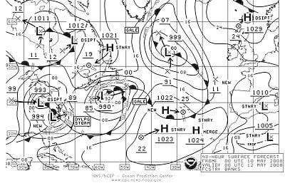
- As the second chart shows, the North Atlantic, even in late spring and summer, can be a rough place. No amount of weather routing will save you from every gale and storm. If you and your boat are not prepared to withstand a multi-day gale or even a storm, you should not cross the North Atlantic by any route.


Monitor the Path of Lows
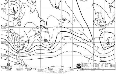
Using weather fax you can monitor the position of the Jet Stream (top map) and particularly the 564mb contour (in bold). As you can see by comparing the two maps, lows and particularly gales generally follow about the same path as this contour. The Jet Stream is a long way south at the moment so I would stay well south too.
As the lows rumble up on my port (hopefully) quarter I would then use GRIB wind field and pressure files (not shown) to refine my course to try, as far as possible, to stay close enough to the lows to have good fair winds but far enough away to avoid gale or storm force winds.
And if I was in a sailboat, as I got further east I would watch the position of the Bermuda/Azores high to make sure I did not get too far into it and lose the wind.

Look Out For the Gulf Stream
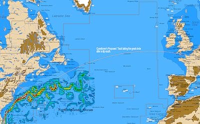
Since we are cruising and not racing, I would de-emphasize the Gulf Stream except to make sure that I did not inadvertently get into a wind-against-current situation. I can tell you from my ocean racing navigator days that given the choice of sailing toward a fair current or a fair wind, the fair wind wins every time. Of course, both at once are nice.
And I would be careful of using the Gulf Stream. As you can see on the chart, it is not just a nice simple river of water heading the way we want to go. There are plenty of eddies and meanders that can deliver a foul current, and even 30 knots of wind apposing the current will quickly generate truly dangerous breaking seas.
There is also a higher chance of thunder storms and other violent weather in the Stream due to temperature differentials.

Stay Out of Ice
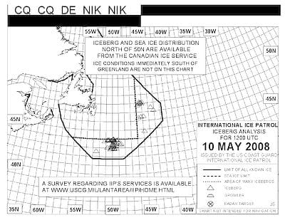
As you can see, the ice is a long way south at the moment. In fact, this is one of the worst ice seasons in years.
I would stay south of the ice line. Even if the ice was further north, I would stay well south of the Grand Banks, to avoid excessive fog. Though I am experienced in both ice and fog, life is too short to go looking for trouble just to save a few miles.
So in summary, and going back to your original question, your basic strategy is a good one and yes, given all the factors above, I would stay well south of the great circle. In fact, I would not even think about the great circle. Getting stuck in one gale on the nose for several days will more than wipe out any gains to be had from a shorter distance.
Further Reading
- Weather Reception and Analysis Online Book
- Heavy Weather Tactics Online Book

Excellent article. First Atlantic crossing ahead. This basic advice provided a great starting point. Thanks!
~ Sam
Hi Sam,
Glad it was useful.
Sir,
I am excited about my first trans-Atlantic crossing. I am planning on starting in late April early May of 2014. Your article gave me some fantastic information and resources.
Thank you,
jim
Hi Jim,
Glad we could help. Have a great passage.
Hello
That was a great article. We are planning to row the Atlantic the ‘wrong way’ for New York to the Scillies in June 2014.
Bearing In mind that once we pick a route we are kind of stuck with it, do you have any advice as to where to go at that time of year that avoids damaging winds. Our vessel has a small structure at the stern that can catch a following wind but a head wind will push us back.
Many thanks
George
Hi George,
Hum, that’s a hard one. To get fair winds you will need to go well to the north, along the traditional sailing ship route explained in this post but there you will be at a higher risk for gales. I guess, if it were me, I would make an in depth study of how the strong wind belt was setting up over the spring and set my route to try and stay on the edge of the Bermuda-Azores high, far enough in to avoid gales. Monitoring and using the strong wind belt, together with recommendations for resources is covered in this chapter in our Online Book on weather.
One caution. Given the speed of a rowing boat, it is very unlikely that you will make your entire voyage without “damaging winds” no matter how smart you are in your routing, or who you hire to help you.
In other words, you and your boat need to be equipped to survive gales and even storm force winds, particularly since there is a realistic chance that you could get hit by a hurricane, or the extratropical remnants thereof.
Thank you very much John….I will be making an in depth study in the weeks prior to departure.
The vessel will be set up with all available safety devices.
Best regards
Gorge
How’d it go? Did you make it? I want to do it solo in a mirage drive tantdom Hobie. Is that realistic do you think?
Hi Loostah,
In a word, No.
Most (all?) of the boats that have safely rowed across the Atlantic were built for the purpose and designed to take heavy weather and even a roll over. Crossing in a Hobie would be akin to Russian roulette with at least 4 chambers loaded.
I’d say all six chambers would be loaded. It would take weeks at the cruise speed of a tandom Hobie. After 24 hours without sleep you start making bad decisions. After another 12 to 24 you will die just from pure lack of sleep even if your bad decisions haven’t already killed you. If you do manage to sleep in the boat, you will eventually get flipped and drown or die of exposure after being separated from the boat. There are far cheaper and less miserable ways of committing suicide. People who row across do it in self righting boats with little cocoon-like sleeping cabins and adequate storage for food, water, maybe even a little cooker. Not nearly what you would call “cozy” but survivable.
Great Article John! And Thanks for it!
we are actually planing to cross atlantic from Europe to Brasil during the may 2014. do you have nay suggestion for us? The Suggested route is by the Cape Verde and the Fernando de Norah to get to north of Brazil. Any comment on that?
Cheers!
David
Hi David,
We have a series by Colin about his voyage by that route than included deep analysis of the strategic and tactical issues.
Hi John,
What can I expect in a route Natal(Brazil), Fernando de Noronha (Brazil) to Canary’s Islands and then to Lisbon in mid May 2014 in a cat Lagoon 380? The crew is my wife(60) and I (63). Both acustomed only to coastal navigation.
We’d appreciate your tips and advices.
Greetings,
Gilberto & Eliana
hey john, sam, Gilberto..
and the internet ..
Im also gonna cross this spring..
im thinking about were to sail to be able to buy and retrieve a good big in good condition sea anchor…. gilberto you should definately have at least a boat break.. im 12 tons and can take strong wind without much regression, but a catamaran moves with the wind and waves from the lightest breeze.. i know how it is.. a 27 foot, 1 ton trimaran in a gale gives some xp.. trust me, it was not that smart!
any experienced guy or girl that wants to go from the caribe to eu in some months when all is ready..?
chau pues
Justme, i am looking for a sailing boat from the carribean to europe around may. I am an experienced sailor, albeit in the coastal areas of the Netherlands and Germany. I have no ocean going experience, but intelligent and eager to learn!
Thank you for this document!
It was a very good lesson about jet stream.
I will cross the Atlantic back to Europe in May-June with ARC Europe after I crossed in November with ARC+.
My boat, a Hallberg Rassy 35 Rasmus is 39 years young and I hope to cope with this challenge.
Ho Cobi,
Glad it was useful. You will find a lot more that will help in our Online Book on weather including detailed information on weather reception with a trans-Atlatic example.
John,
FYI the link you left for your online book on weather actually links to an AGM battery article. While it’s easy enough to find the weather book, I figured you would want to fix the link. Thanks for all the hard work, I’ve been extremely satisfied with my membership investment.
Steve Cleary
Hi Steve,
Oops, thanks for the heads up, fixed now. Also, thanks for the kind words.
Hi, where does one find a description of where the ice is at any one time?
Hi Peter,
The Canadian ice service: https://www.ec.gc.ca/glaces-ice/