
Ok, I’m not trying to start a war with that headline…really, I’m not…honestly.
Rather, I thought it would be useful to explore the strengths and weaknesses of all three. And, yes, I only put “best” in the headline to make you click on it. (Got to make a living, you know.)
In fact, there are way too many variables here to ever say one is “best”, particularly since “best” depends on boat configuration, usage and, yes, personal preference, too.
So rather than make a pronouncement, I’m going look at the pros and cons of each.
And here’s the thing that makes this useful. Most people who opine on this subject tend to sing the praises of whatever they have, but when asked what else they have tried, the answer tends to be:
…well, nothing…but I know my preferred choice is best because…
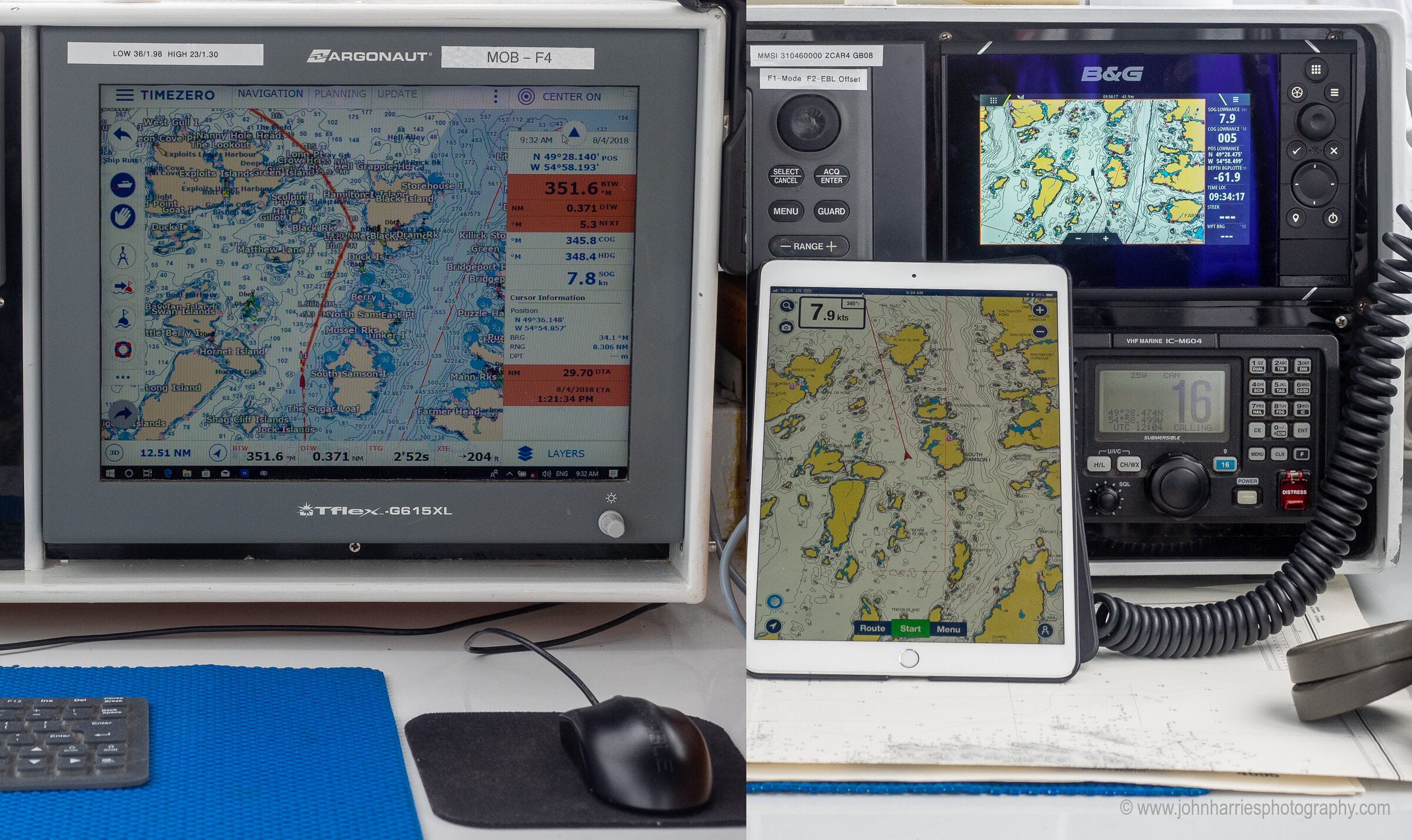
There’s a name for that: confirmation bias. So, in an effort not to fall into that trap, Phyllis and I installed a plotter two years ago, and have been using it, along with our computer-based system running TimeZero (TZ) Navigator, and an iPad Pro running Navionics and most lately TZ iBoat. (The iPad has long been our preferred backup to the computer.)
That said, obviously my personal experiences and prejudices will influence this. Total impartiality is impossible for a human being, and anyone who tells you different is full of it.
On the other hand, I have been a navigator for some 50 years, and I have also spent most of my working life in tech, much of it evaluating hardware and software, so my observations will at least give you something to think about before parting with your hard-earned money.
Comparison Framework
To keep this organized I’m going to compare the three in five areas:
- Ease of use
- Functionality
- Reliability
- Installation ease and flexibility
- Cost
And a final caveat: I will not be evaluating or debating the merits of the options within a category; for example, if you have and prefer Coastal Explorer (I hear great things) over TZ Navigator, or Navionics over TZ iBoat on a tablet, I’m totally cool with that.
Let’s dig in:
I have never liked the idea of an iPad for navigation, nor used one for navigation, so I can not advocate for that approach. But I am trying to challenge my own bias and have a couple points I would be interested in your thoughts on. On reliability, I certainly agree with all your points, but also have some additional thoughts. Apple sold nearly 10Million iPads, and around 60Million iOS devices in the 4th quarter of 2018 alone, with an impeccable reputation for quality. I can’t believe any chartplotter could afford to match the testing and manufacturing QC, at least on the hardware/OS side, of Apple (granted the nav app is 3rd party and may not be as reliable as hardware/OS making that the weak link). Second, anywhere on the globe with an internet connection you can update an iPad. Much easier than updating a fix mounted chartplotter, making your charts more current, and easier to update software as bugs are fixed, if you feel the need, improving reliability (granted updates can also break something that is working just fine, so there is risk here too). Third if your iPad dies, you can replace it just about anywhere in the industrialized world though a standard retail shop, and load your nav app through the cloud and be up and running very fast and relatively cheap, a chartplotter not so much. You can also store multiple spare iPads and still be $ ahead, adding some fault tolerance to the equation. Fourth on a boat not running a generator, powering a laptop and large cockpit display I would assume burns a lot more power than an iPad with all the time Apple spends trying to optimize battery life, would that be a fair assumption. Thoughts??
Hi Robert,
I would agree with all of that, except perhaps the update issue, in that most plotters can now be updated over the internet.
On reliability, I certainly agree with all you say on the iPad. I chose the plotter first for reliability based on two things: waterproof, and not compromised by other non related software—my non-navigation iPads have gone bananas at least one a month due to app interactions. Do those two outweigh your points? I think so, but, as I said in the piece, the only way to know for sure would be a long term study.
Easy updates is a two-edged sword. As you noted, software updates are just as likely to break something as to improve something. I update the software on my navigation tablet only under controlled circumstances, and once everything has settled down and is known to work, I do not let it talk to the internet under any circumstances!
Hi Chuck,
I agree, see #5: https://www.morganscloud.com/2014/10/27/6-tips-to-stop-marine-electronics-from-ruining-your-cruise/
We have a cockpit mounted plotter from Raymarine with Navionics charts that has worked well for more than 5 years, with one fault repaired under warranty. Down below a windows PC running OpenCPN. In the Pacific it’s vital to have a PC on board to display and overlay Google Earth images on charts that can easily be 1nm out. That said we run the systems independently, with separate sources for GPS, which is good for reliability, but does make navigating a pass tricky as you need good comms from down below to the cockpit. Incidentally we have an iPad and Android tablet with Navionics as further backup!
Hi David,
Sounds good. That said I really do like to have the cockpit display, whatever it is, integrated in real time with the the computer below.
And good point about the benefit of Google Earth. I too have used it a lot in the north where the charts are sketchy. That said, sadly Google have abandoned their GE free standing program, so it’s more difficult than it once was to scan an entire area before heading out, and then be able to use the information while offline using the GE cache.
This article came at a good time as is an area we have been thinking about on a new to us boat. It is interesting that the computer is your preferred option and I wondered if power consumption can be an issue? We have been looking at a dedicated Raspberry Pi running openplotter, have you had any experience of this?
I’ve been running a raspberry pi/openplotter onboard 24/7 for few years now and would miss it dearly if it were to vanish overnight. Power is a few hundred mA so it stays on all the time. Signalk is one of the major benefits, all data goes in there though still a standalone gps/ais/radar should it crash. With siganlk/openplotter setup is easy, apps installable much like a mobile phone. All data gets saved to a database for plotting which is gold dust, accurate barometer/battery voltage, engine temperature etc – bit of wiring involved but fantastic data to have on a cruising boat. I run a Pi3 which is plenty fast enough for me , a lot of work gets done on a laptop anyway with the Pi creating a wifi access point so doesn’t matter so much what device you work on. Cheap enough to buy one just for a play, needs a good 5v power supply though.
Hi Angus,
Power consumption with Apple’s computers is really not that bad. And no I have not done anything with a Raspberry Pi, although I would guess that the power would be less than even a Macbook Air or Mini. That said, I think we need to look at overall power use, and in this case the Pi may not be that big a saving since you will still need a screen and all the other stuff to provide data inputs.
I did not mention the Pi because I regard it as a geeks only solution, and anyone who is geeky enough to be comfortable with getting it all set up, including open source software, is geeky enough to make their own decisions without help from me.
“I did not mention the Pi because I regard it as a geeks only solution, and anyone who is geeky enough to be comfortable with getting it all set up, including open source software, is geeky enough to make their own decisions without help from me.”
– not these days, copy some files onto an SD card and turn it on 🙂
Setup is telling it where the serial data is. Probably easier than a laptop as the latest opencpn & all the plugins are there already.
Is anyone else using signalk? Really is a fantastic resource on a cruising boat, use as much or as little of it as you want.
Hi Crag,
As a guy with geek tendencies, but one who spent years in software support, one thing I can tell you for sure. The biggest sign of a true geek is that they underestimate how difficult geeking is for non-geeks!
Try it first! 🙂 Or better still, buy a Pi and get a normal sailor vaguely OK with turning on a computer to install.
Just installing openplotter V2 beta, no more geeky than loading opencpn to a laptop. Download and install one file then it’s menus from there on in. MUCH easier than getting a laptop up and running . And light years ahead in features & apps should you want more.
Hi Craig,
You just proved my point! 🙂
For other’s interested, here’s a good place to start: https://projects.raspberrypi.org/en/projects/raspberry-pi-setting-up
But before you disappear down that rabbit hole, read this:https://www.morganscloud.com/2016/01/08/marine-electronics-system-recommendations/
Well, 99% of that setup link applies to any computer and having just installed openplotter on a Pi3B+ which involves downloading a file, unzipping it an copying the contents onto an sd card, put in the Pi and turn on – if anyone struggles with that they’ll struggle with any tablet or computer, possibly more if networking any data and setting up opencpn. Really, if that’s too hard for a cruiser then any computer/tablet will be a struggle.
Once installed signalk is there, opencpn is there with menus to update , install plugins etc. Signalk has menus to set up data coming in from nmea 0183 or 2k or signalk.
Really think it’s ripe for an article, get a non geek to do it then report back and also see just how powerful signalk is! Signalk is worth several pieces on its own, it’s such a game changer 🙂
Openplotter V2 is not released yet but anyone wanting to play can get it from the link here, or download the openplottersettings deb to run on any linux machine ( it says )
http://forum.openmarine.net/showthread.php?tid=1992&pid=10280#pid10280
Hi Craig,
True, perhaps, but you moved the goal posts to make your argument. Remember I’m recommending plotters for non geeks, so comparing to computers does not apply. I already classed computers as geeks only.
As to tablets, way easier because you get an instant solution with no interfacing, albeit without AIS and heading, but those are pretty easy.
Whether or not a computer is easier than a Pi with signal K is a different discussion…and for geeks.
Ah, fair enough. Though every cruising sailor really needs to be a geek then as computers are pretty much essential living afloat these days. Maybe low level not very good geeks, barely worthy of the title 🙂 Though the majority of cruisers I know are fine and get by, I suspect your choice of words might make it seem to some as harder than it is, knowing a little about windows doesn’t quite get to geekdom imho, though that’s just semantics really. 🙂
Raspberry Pi is discussed here. I have no experience with it, but have read a bit. It uses next to zero power and it can use a tablet or phone as a screen, if wanted, so that’s a winner. I have to agree with John that it’s quite far into nerd territory, though. Not because it has to be so difficult, but because it can be, and and is presented as a nerds item. It’s not really presented for normal consumers as a product you can just use. If you do want to nerd out, I think Raspberry Pi can give you lots of very fun exploration of how to make your boat do fun stuff. 🙂 There are really some quite astonishing possibilities.
If you want the feeling of buying a normal consumer product, for some reason don’t want Apple, and still want the illusion 🙂 that you can just plug it in and use, you can look at Intel NUC, Next Unit of Computing. They’re micro versions of desktop computers. They run Windows 10 or Linux, for the more nerdy of us. They mostly use the more powerful versions of laptop hardware, so they can be impressively strong, albeit not the same level as a full desktop version. Especially the laptop style processors are considerably slower than their desktop siblings, to save battery power and avoid the volume of a big heat sink with a fan.
NUCs run on 11-19 Volt DC, so they can run straight off your 12V boat system. They use more power than a Raspberry Pi, but a lot less than a laptop, especially as they can also happily work with any screen, like wireless to a tablet. They can run up to 3 screens simultaneously. They’re also bigger than a Raspberry Pi, but still tiny. There are 3 box formats, but top view is mostly 11 x 11 cm! Height is about 6 cm. They come with a Wesa mount, to fit on the back of a normal monitor.
Apple Mini is about the same format, slightly bigger, but mostly more expensive and not as easy to change parts inside if you want to upgrade. Most likely, it’s still a better quality option, being an Apple product, even though I haven’t tested it. I don’t know if the Apple Mini runs straight from the 12V boat system.
Hi Stein,
I agree, the NUC looks like a very nice option, particularly for the price. And I’m guessing that the reliability would be pretty good since it comes from Intel.
Hi Stein,
The latest NUC 12 Pro Kit NUC12WSKi7 still allows for 12-19V input – thanks for pointing this out, I was under the impression that I needed 19V. You can’t beat the price – performance: it is only 140 USD list more than the CPU alone (12 cores, 16threads), you can run up to 4 displays (TZ supports “only” 3) and it can be souped up to ½ TB plus 1 TB SSD drives and 64GB of RAM. The fan hardly ever comes on, so it is quiet and it can be mounted to a bulkhead. Have been using one for six months now and it is really amazing. Friends have reported 5plus years of trouble free use – they become obsolete before they break.
Hi George,
Thanks for the report on the NUC. That does indeed sound like the cost performance leader for navigation computers.
Another plus for computer is the wealth of weather data you can display, opencpn lets you overlay gribs with sat images with synoptics –
https://i.imgur.com/6C2351D.png
Or a screen grab of marine traffic density overlaid –
https://i.imgur.com/tT3J5HV.jpg
Hi Craig,
Good point, although to be fair you can do most of that on a tablet too, albeit with more messing around.
I don’t disagree with much of this although I do think that the computer option is probably over complicated for many people unlike John and I with IT backgrounds – especially in a Windows environment these days with Microsoft going to a cloud based model that constantly searches the cloud for patches and auto installs updates (and far worse “upgrades”). Getting all that gear setup and communicating usually requires drivers and the like which renders it much more complicated than plotters who generally work with NMEA out of the box. Yes, you can (and probably should) keep you Windows implantation out of date and I know lots of boats that are still running Windows XP because that’s what their nav package supports but that sort of defeats the whole advantage of computers as these things DO upgrade as need capabilities are added and it’s getting harder and harder not to connect them to the inter web (not a good idea for a dedicated nav computer running out of date Windows).
I did want to point out however that the logical redundancy for an iPad is an iPhone. Most apps bought on an iPad work perfectly (and for no extra cost) on the iPhone as well. This also gives you a redundant GPS source as well. I’ve used my iPhone (running Navionics) to check up on plotters (and computers) especially when they are running some other charting package. The newer iPhones all have massive screens (for a phone) with higher resolutions than most of the iPads so it isn’t really a stretch even with these ancient eyes. Yes, they are small for 50+ year old eyes but if you are using it as a check, you can leave it zoomed in and use the iPad or plotter for the big picture.
I agree with John that entering routes is much easier on a computer with a mouse but that’s an interface thing and mice are now available on iPads as well as he suggests. I don’t know why the main plotter manufactures haven’t cottoned on to the idea of adding mouse support. They could charge hundreds for it and people would still pay.
I won’t say which is “best” either because in my world, I don’t have to make that choice. I’ve had all three (4 I’d you count the iPhone) and use each for what they are best at. If forced I’d pick 2 and then get AIS and Radar before going for the third but I do believe you should at least try to have 2 with different chart sources as nothing is perfect and redundancy is key.
Hi Brent,
Sadly I just discovered that the new mouse option on iPads is so crippled that it’s really not much use. Bummer.
John, as a Mac user have you tried using your iPad with Sidecar, a feature of the latest MacOS and iOS, which lets your iPad be a screen of the Mac. This of course means you can have your iPad (Mac screen) and wireless mouse in the cockpit, running Mac software…
Hi Charles,
Not yet. I always wait 3 months for Apple to get the bugs out before I update the operating system. That said, it sounds like it could be great. Of course it will only work with Mac OS, not Windows under boot camp, so we are then limited to navigation programs that run native on Mac.
The other option under Windows is TimeZero on the computer and TZ iBoat on the mac with realtime route update. That said, neither are as simple and robust as just having a waterproof second screen and mouse in the cockpit.
Ha ha John OpenCPM in your text….that give a clue to your age – remember CP/M ? Very interesting article, you would have fun with your setup to have also a Furuno ChartPlotter because this is what i have and then there is a complete integration and also a 17 inch color radar that take the full advantage of the dual-digital radar installed on the boat (DRS4D)
So here i stand for my sailboat: 2 Furuno Navnet chartplotter, 2 HP 17 inch Windows 8 laptop (a third laptop stored as spare, a third Navnet bought on ebay for 400 $ as spare also since the Navnet feed the radar). One NMEA 2000 network with Gyro, AIS, autopilot, Radar XM weather. One Ethernet network for radar, weatherfax, computers. I agree it is a little bit complicated, if i could i would have uploaded the network diagram – it would discourage many of trying to install such a system. Perfect when all works…the same setup as the Canadian Coast Guard cutters.
All Windows computers run TimeZero integrated with Furuno Navnet and radar. But they also run OpenCPN with wordlwide maps -just in case. And i have an Ipad with maps just in case also. Redundancy is key…
As you said the most important is to tailor the equipment/software to ones ability especially at sea. (i carry all my software tools to manually boot computers, copy and modify disk partitions…)
Hi Andre,
Woops! I will fix it. Of course this must mean that you are an old guy too, since you know how the mistake came to be!
I particularly agree with “the most important is to tailor the equipment/software to ones ability especially at sea.” I’m guessing you have some software and/or hardware customer support and so understand how important it is to tailor the system to the user’s technical skill level.
Many years ago, I learned that “All complex problems have at least ONE simple solution … That does not work” … John, I agree with your analysis.
Being in my seventies, I have been through several generations of navigation equipment with many different crew members …
Now I sail my X-342 sailboat – the tiller-version – in the archipelago waters around Norway, Sweden, Finland and Denmark – often singlehanded …
It is – therefore – a must for me to have direct access to the navigation gear and the VHF in the open cockpit. From my place, I can see the instruments – SOG, COG, log, depth, wind over the hatch – and must be able operate the navigation equipment and VHF with ONE hand.
For several years, I used a waterproof touchscreen in the cockpit connected to a laptop running Windows and OpenCPN or TIKI – securely placed downstairs in the cabin.
Splash/rain and the use of gloves made it somewhat difficult to operate.
I could control it via a wireless mouse, but that was not easy in an open cockpit …
I still use the laptop with OpenCPN – now with the new oeSENC charts – for route planning and logging of tracks and backup, but it stays secured and dry in the cabin. The new oeSENC charts can also be used on Android units with OpenCPN.
In the cockpit, I prefer a robust chartplotter – with buttons, so I can operate it with one hand – and cabled interface to AIS and the autopilot, and a wireless VHF. I don’t have a radar.
In my pocket I have an Android phone with Navionics and Plan2Nav and OpenCPN. I’m still surprised to learn, that other sailors find that solution safe for navigation. On a clear day, I have problems reading the screen, and it is not easy to operate with one hand, and it needs some kind of waterproof bag and charging device. For me the phone is a back up device … and very useful for many other purposes.
In a metalbox in the oven, I have an Android tablet with the same software.
I agree, that there is no universal solution for all … no “one size fits all”.
In *my* sailing situation, the preferred solution and primary navigation equipment is therefore:
A cabled, robust chartplotter – interfaced to the autopilot – with buttons and touch facilities and AIS – that I can see and operate from my tiller position in the open cockpit.
Hi Flemming Torp,
That all makes sense to me. And I totally agree about the dangers of navigating on phones.
I just took a look at your X-342. This is just the kind of boat and sailing I’m thinking about for my 70s so good to know that someone has gone before me and is making it work well.
Have navionics on a lifeproofed 10.5” IPad times two.
Three Raymarine screens -12” at nav station, 12” at helm, 10” under hard dodger. Any can serve as the master.
Open on a toughbook down below.
That way running three different chart sources, Three different totally independent systems. Only single sourcing is radar/real-time AIS/ real time local wind,depth, temperatures etc. AP runs through the RM devices but the IPads WiFi into that system.
What’s most important for a cruiser is redundancy. Belts and suspenders. Think at this point long term cruisers should have at least two of the three. Ideally all three. Think concern about “best” is silly. Concern should be “best” in each class of device.
Also have an old handheld Garmin as a last resort after a lightening strike if the faraday stove box fails.
Hi Lee,
I agree that redundancy is good. That said, I think we have to be careful about introducing too many different systems and charts into one boat. I’m more comfortable with a hot spare that is the same as the primary system so we will be totally familiar with it when if a sudden change is needed at say 3:00am on a black dark night in filthy weather, on only two hours sleep in the last 24.
https://www.morganscloud.com/2014/03/23/do-you-still-need-paper-charts-part-2/
Sorry John. In my practice I use tablet 95% of the time, plotter about 5%. I gave up on using laptop because is too big, not mobile, awkward to handle etc….small boat 35ft. BTW Samsung Galaxy itablet is wayerproof….
Just FYI
John, it seems like you are making an excellent case for all three systems.
On Tumbleweed we have been using a B&G chart plotter, Open CPN running on a cheap PC and another copy on a MacBook, we also use two iPads – one new and one ancient. There are many situations where the benefits of one system are so much stronger than the other systems that it just makes sense to use all three. Douglas is a software engineer and I’m a couple rungs up from a Luddite but even so I have never felt overwhelmed by the technology.
We use Open CPN for route planning and to overlay Google earth images, incredibly handy in the South Pacific and I’m sorry to read that feature is no longer supported.
In addition to thinking of iPads as back ups, the other benefits are that many local charts or region specific apps will only run on a mobile OS. One example is the excellent NewPec Smart charting app in Japan. After using it for several months I can’t imagine sailing in Japan without it. A mark against iPads and other mobile devices is that they at times will lock up when it is time for an update. Two years ago sailing from Suwarrow to American Samoa one of our iPads locked up and refused to restart until we reached an Internet connection. It became a topic of discussion on the daily SSB net, several other boats experienced the same problem.
Instead of taking the lowest budget approach of having two Android tablets it seems better to have Android plus one another system, in the event there were updates for one OS that locked up one version.
Portability of laptops and tablets are good features, when we get together with other cruisers we share information and mark suggestions on the charts, better than trying to decipher my scribbled notes later.
The B&G chart plotter has been a stable system but to update routes, add waypoints, plan our passages, etc, we need to be in the cockpit. Of the three systems the chart plotter has been most susceptible to weird glitches such as locking up when we were sailing near the international date line. And it’s a significant power draw. But with the ability to overlay radar, display AIS, and run information from the various sensors it is provides much more information than the other two options.
Can I add that I love paper too?
Hi Morgan,
A very good point and valuable warning about problems with updates, particularly on tablets:
https://www.morganscloud.com/2014/10/27/6-tips-to-stop-marine-electronics-from-ruining-your-cruise/
Hi John and Phyllis. My Rival 31 is fitted with a Furuno Navnet 3d plotter at the Nav station. Im not a fan of installing hugely expensive electrical devices in a positon exposed to the marine environment and figured I could see the plotter from the cockpit on my small boat. Hmm. Not to be if you want to safely pilot via electronics. Ive ended up with a 15 inch dvid monitor mounted under the spray hood plugged into video out on the plotter. The whole thing is a kind of hybrid with most functionality controlled via wireless track ball connected directly to the plotter USB. I find route planning and manipulation very straightforward using the mouse interface. I do however consider the monitor a ‘consumable’ as it is not marinised, however it is surviving pretty well and is not mission critical. I do carry a back up android tablet as well as paper charts. I have no way of feeding gps to the tablet and rely wholy on its internal gps. I would not feel comfortable using a tablet internal gps on mission critical equipment and would want a position feed from a waas antenna. Small boats do present a special problem especially if you want it all, with radar and all the other trimmings displayed in the cockpit. This way I keep the expensive electronic equipment below but also have access to all information in the cockpit. The biggest downside to this set up is one of power consumption of the monitor, it does run on12v directly but adds a big load. I really like the thought of purely tablet navigation but if you want radar information in the cockpit something has to give. Incidentally appart from one incidence of the Navnet 3d crashing very early on after its purchase there have been no issues with it at all for the last 10 years, and yes it did crash during an awkward tidal channel which was a lesson in itself, do not get so wrapped up in your electronic position that you lose grip on your position in the real world. A spin off of this is that you must concentrate on sailing the boat at that point and not trying to get your electronics back on line because too many moments of inattention may well see you pushed somewhere you dont want to be by the tide. This is an interesting topic in this age when ECDIS is replacing paper charts on commercial ships and ships can now be certified to operate without paper methods of navigation.
Hi Tristan,
Hum, I really don’t love the idea or a consumer grade monitor out in the cockpit. Not only are their reliability issues, consumer monitors are difficult to dim properly to preserve night vision.
If it were me, I think I would go with a plotter and tablet solution. I just tested this on a small boat in the real world for a week and it worked well:
https://www.morganscloud.com/2019/08/27/12-electronic-navigation-tips-from-a-cruise-on-someone-elses-boat/
We have a Windows 8.1 computer inside the pilothouse, a standalone Furuno radar that doesn’t (yet) talk to anything else (I like it that way) and a B&G plotter at the helm. The B&G “Link” software for Android allows a wifi connection with either my phone or my LG tablet; the latter can show me (and allow me to manipulate) the plotter display even through the steel sides of my pilothouse, which frankly surprised me, even though I consider it merely “nice to have”. I did find it useful to display my forward-looking sonar to the tablet on a calm day, when I could actually see a large rock on the seabed from the bow I saw first on the tablet screen. I anchored elsewhere.
I would welcome your recommendation on the most watertight and functional tablet cases, as I only take the thing on deck in fair weather at present. I haven’t made up my mind yet about an outside helm display being either a wired or wireless repeater in the form of a rugged screen, a waterproof-cased tablet or an entire second plotter.
Hi Marc,
See the link in the article for our recommended waterproof housing for the ipad. Search on “solved problem”.
Thanks, John.
John,
So many variations posted here. That’s the beauty of our current world. Ours is similar, but slightly less robust. A 7″ Simrad GO7 mounted below at the chart table and two iPad minis in Lifeproof cases that can be mounted at the binnacle with a Ram mount. Wifi from the GO7 sends the iPad its entire plotter repertoire, minus the autopilot functionality. Also integrated are a depth sounder, Simrad AP, B&G wireless wind, which has its own display on the cabintop bulkhead and a Simrad VHF with an AIS receiver that can be overlaid on the plotter and therefore the iPad. I find that I get about 6-7 hours of run time with the iPad before it needs to be recharged, hence the need for two. Obviously a good hedge if one were to crash as well. I tried running a charge cable from a cockpit charge port to the unit while in use on the binnacle, but the cable became quickly corroded and it was also a hazard running across the cockpit floor. We do sail with a macbook pro, but I’ve not thought to install navigation software on it. Years ago, I did use an old pc with OpenCpn and a stand alone gps receiver, which I still have. Perhaps it’s a good idea to get that up and running on the macbook. It’s not ruggedized, but would still be a nice backup. I also carry a small Garmin battery operated handheld color plotter as well as an ancient Garmin B&W handheld that still works! I wouldn’t want to try a tricky channel passage with it, but at least I could use it like a sextant to plot a position on the paper charts that I still drag along. As for that hypothetical channel passage without a working device? I would think a daylight passage with tide tables and paper charts plus proper visual recognition of the navigational aids would do nicely.
Like Angus, I am in the process of deciding what electronics to use on our boat. We have a small boat so space is very limited. I have been leaning towards a setup like John mentions might work well for a small boat, using a plotter and a tablet.
However, I have a concern about the tablet. When in direct sunlight my iPhone has overheated and shut down in a very short time. I’m concerned that a tablet might do the same thing. For those of you with experience using tablets, iPads in particular, do you have problems with them in the heat and sun?
Hi Keith,
I use an iPad Pro 12,9 from 2017. It’s great in many ways, but direct sunlight isn’t one of them. Overheat shutdown can happen, but the immediate problem is that direct sunlight will reduce screen visibility a lot. It still works, but giving it shade is a necessity.
Another issue is that a phone, tablet or such that shuts down from overheating does so to protect itself, not because of poor quality. They have lithium batteries. The battery life gets dramatically shortened by heat. One full day in the sun can kill a new battery completely and will at least reduce its longevity a lot, as in potentially years shorter. Lithium batteries should ideally be kept cool, like fridge, at a fairly low charge level, like 30%. Then they live long. That’s not a realistic usage scenario, of course, but being very careful with heat will pay off. Take it out of the pocket… 30 degrees C is a threshold. Heat and overcharging is what kills most of them.
Hi Keith and Stein,
Good point on the overheat shutdown problem with tablets. That and daylight brings up the important point that a tablet should be installed out of the sun. Under the dodger is probably the best place.
Yep….learned to keep the ipad shaded (just like me!)
We just completion our first season with raspberry pi set up (one static screen @ nav table and an old iPad with mirrored screen for cockpit.
Works great BUT just a warning to anyone that tries this; set it up at home first during winter so u have plenty of time troubleshooting/googeling/throw things before season starts.
TBH we would much ratger have a MFD/plotter But We are somewhat one a budget and have to prioritze. This sure is much bang for the buck.
“Works great BUT just a warning to anyone that tries this; set it up at home first during winter so u have plenty of time troubleshooting/googeling/throw things before season starts.”
Those days are gone 🙂 For the software side anyway, openplotter V2 has menus to choose whatever you want to install with a click of a mouse. Most of it there already but not officially released.
Hi Craig,
Sorry, I’m going to get a bit harsh, but it needs to be said. Are you seriously suggesting that someone use open source software for a mission critical system without prior onshore testing? And this is doubly inadvisable when you say “Most of it there already but not officially released.”.
Us geeks do no one any favours by letting our enthusiasm for new and cool tech lead us into suggesting such a course of action for a mission critical system like navigation.
Navigation is not a video game where we can just reboot without consequences when it craps out.
“Are you seriously suggesting that someone use open source software for a mission critical system without prior onshore testing?”
No, not saying that at all. What was said is that set set up process is easy, not a winter of googling/trouble shooting to get it up and running. Testing is for sure very important – as with any new nav system, but setting up a raspberry pi is not difficult, even with the released V1 openplotter. With the imminent openplotter V2 release it is even easier. I’ve been running a Pi 24/7 onboard for many years, set it up and don’t geeky fiddle under the bonnet and it’s been completely rock solid.
Your 2nd 2 sentences pretty much apply to any nav gear, computer or otherwise.
Hi Craig,
That’s a relief. Glad it was a misunderstanding.
Hi Jacob,
A very good and sensible warning “Works great BUT just a warning to anyone that tries this; set it up at home first during winter so u have plenty of time troubleshooting/googeling/throw things before season starts.”
I have seen so many cruises ruined, or at least severely compromised because the crew are messing with tech rather than focusing on sailing and seamanship. So doing can actually be dangerous too.
I have
– Adrena and Ezpedition running into a dedicated computer
– 3 B&G MFDs connected to an H5000
– iPads running ISailor, with Transas charts and the ability to connect to your boat’s NMEA 0183
My experience has been that each has its uses. The MFDs are readable in sunlight and reliable but the software configuration tools are horrible and the user interfaces are worse and non-intuitive.
The PC based systems work well but are too complex and are inaccessible at the helm
ISailor on the iPads are far and away the best but not readable in sunlight, can easily slip overboard, need recharging, don’t work when wet, and don’t have many sailing features (laylines, etc). I add that iSailor has hands down the easiest-to-install, most readable, and least expensive charts. Purchase and installation of charts on other iPad apps including Navionics and Embark is miserable because the download process is miserable.
But these hassles are small compared to the stupidity of needing to get SD cards or (worse) CDs or (worse worse) ENC files from random websites (over marina connections ? Good luck with that). and complex install procedures.
The reality is that the sailing market is small. Development work for sailors is going to be limited, and we’re going to be stuck improvising between different tools to create solutions which work for our individual needs, which change according to what we are doing and the amount of time we want to waste on figuring out technologies.
Hi Tim,
Have a try of TZ iBoat. I was using iSailor, but have found iBoat way better and easier to use. Also shares routes elegantly with MaxSea.
I have tried many systems since the Decca and Loran times. I take what there is on board. And for some years now I have always my iPad with me an use the apps I’m familiar with.
But what I never want to miss on board is the ultimate backup system: charts, binoculars and a good bearing compass.
Hi John,
Great read, thanks!
Two thoughts:
Very interested with your recommendation of a computer down below and a ruggedised screen in the cockpit. How does the ruggedised screen work? Is it just to visualise what’s on the screen down below, or do you control it it some way too?
Secondly, I’m really impressed with the Furuno/TimeZero Navigator integration. It’s possible to share charts across both a laptop and MFD, with two laptop installs allowed per license (so you can keep a backup laptop for redundancy). Routes can also be exported from TZ to the MFD without fiddling with SD cards, and there are options to use TZ to visualise Furuno radar and sonar. It’s therefore perfectly possible to have a completely integrated system (which many like but I know you don’t) which also has the redundancy of a backup laptop.
Hi Stefan,
The screen on deck is fully functional. See further reading for a link to an article with the details.
And yes the Furuno/Time Zero integration sounds good. That said, it is way more expensive (think double) the cost of our computer based solution and also requires one to use two very different interfaces, which I don’t love.
Thanks for the reply!
Yes, the TimeZero plus Furuno solution is expensive. Even Timezero V4 alone, with the radar, sounder and routing modules, will set you back US$ 1750.
Still, the latest products from Argonaut (where you can mirror Android or Windows at the helm with a rugged touch screen) are a step in the right direction to eliminating MFDs altogether.
Great read though and am also learning a lot from the comments!
Hi Stefan,
Yes, I like the Argonaut a lot since we have had one of their screens for 10 years with no problems. Not a fan of touch screens though. One thought for you, although I know it’s common to put the screen at the helm, I don’t think it’s a good idea, except maybe for single handers. Just too much temptation to be messing with the screen when we should be paying attention to handling the boat. Better to put the screen under the dodger where a second person can manage the navigation while the person on the helm keeps their attention on the surroundings.
We have a pilothouse and a second helm (the “sailing” helm) without a dodger and with a solar panel arch acting as a bimini. There’s no real need to have a plotter out there in the daytime, but at night, a properly dimmed display that repeats that of the “inside” helm’s MFD can be useful in certain circumstances, such as displaying data from wind instruments or showing approaching AIS targets on the edge of detection to determine if action is required. Less obvious is the use of FLS to detect awash debris in the ocean, although that functionality is limited and one must act quickly at typical cruise speeds. This doesn’t necessarily apply if there’s more than one watch-stander, but that’s not always the case in the middle of the night.
This is why I like the idea of a waterproofed tablet. It can be kept below and recharged during the day. Most go easily on a RAM mount.
Hi Marc,
I’m pretty sure that FLS is not useful for floating debris. Echopilot, the long term leaders in the field, worked on this a lot some years ago and concluded that it was impossible due to surface wave interference. And we have had FLS for over 20 years and have yet to see something floating in the water at more than a few feet.
Also on tablets. Recharging below is of limited usefulness. See: #2 https://www.morganscloud.com/2019/08/27/12-electronic-navigation-tips-from-a-cruise-on-someone-elses-boat/
All in all, I think you will be better off with a repeater MFD in the cockpit.
Just finished a circumnavigation, having on board all 3 devices (Garmin plotter, OpenCPM on a laptop, and Garmin on an iPad)
I’d always planned on using the plotter as primary, with the laptop as back up…..but the mobility and ease of use of the iPad very quickly made it the primary.
Aside from being in a water resistant cover, our cockpit is under a bimini, so the cockpit is rarely wet = low risk environment for the Ipad in a holder over the outside helm.
Vesper AIS was also available on the iPad via a separate app – find that far more useful than radar, though we rarely encountered fog 🙂
A separate point…..our lightening strike protection plan was to stuff the ipad and IridiumGO in the microwave – a move that worked for boat buddies…..who lost all other navigation electronics.
Hi Norman,
Yes, I think many end up using an ipad for the same reason. That said, with a fully functioning second computer screen mouse and keyboard in the cockpit, we have never experienced any ipad benefit over the computer.
I guess what I’m saying is that the iPad’s advantages are a function of being able to use it in the cockpit in a boat not equipped as we are, rather than intrinsic.
On the other hand, few boats have the space for the second screen etc that we have.
Having read your posts regarding iridium Go (as of 2/19), I’m still unclear as to whether this system represents a reliable source of data for weather system input. Assuming correct install and appropriate software.
Hi James,
We have a complete Online Book on that :https://www.morganscloud.com/category/weather/book-weather-analysis/
Hey John, useful article. I’ve used all this stuff: Win & Mac, B&G, Raymarine and Simrad plotters, iPad & iPhone. And ALL have one thing in common: they will die, reboot, freeze, update, request key, notify about new release, run into a debilitating bug or do some other horrible thing that will eventually get you in trouble. That goes double for B&G / Simrad, where each new software release seems to introduce a new bug or two. I believe *none* of the above mentioned gear to be made for mission critical. *All* of them are merely expensive toys and should be treated as such. Your life may one day depend on it.
In aviation, mission critical stuff is tripled or quintupled (doubling is not enough as the 737 MAX showed). We should do that too. With the failure rates I’m experiencing I choose for tripling: plotter, iPad, MacBook. All with different software, all with different maps (Navionics, C-map, OpenCPN oeSenc). Note: compare maps in some areas and you might be shocked!
As a variant of Murphys law says: it’s a mistake to let an appliance know you rely on it.
Am I being paranoid?
Hi Rob,
I agree and we have a whole article on how to manage that: https://www.morganscloud.com/2014/10/27/6-tips-to-stop-marine-electronics-from-ruining-your-cruise/
As to having a bunch of different systems, I agree there are benefits. That said, the big downside is that using different interfaces can be highly confusing, particularly when the chips are down in an emergency and we are tired.
So, on balance, I prefer to keep the number of different systems small and use the tips in the article above to manage the risk.
Also see: https://www.morganscloud.com/2014/03/23/do-you-still-need-paper-charts-part-2/
“Note: compare maps in some areas and you might be shocked!”
Quick note – sasplanet (windows only unfortunately) is excellent for jumping between cmap/navionics & various satellite sources to see if they tally up, and save mbtiles for viewing in opencpn, satellite can be gold dust sometimes .
http://www.cruisersforum.com/forums/f121/raster-or-vector-charts-or-both-216169.html#post2860707
Considering the complexities of using multiple interfaces to obtain weather data, is there any serious consideration for using sirius offshore weather system with appropriate plotter as a way to simplify the process?
Hi James,
I have not used the Sirius weather, so I just don’t know how functional it is. But even if it did work, the problem with Sirius is that the footprint is quite small and leaves out large areas of the ocean.
Also, as far as I know, Siuius does not give us email, which most cruisers want. So given that we will need GO! or something like it, anyway, it just makes sense to use it for weather too. While getting weather on GO! may sound complex, it’s actually pretty simple once you get started, particularly since we have full instructions: https://www.morganscloud.com/category/weather/book-weather-analysis/
Hi John,
On my Seawind 1260 Cat I have a B&G Chartplotter – but find it much nicer to create routes using the Navonics app on on my iPad (only use auto-routing for quick planning). One super useful feature with that is that you can synchronize between the iPad and Chartplotter the routes and waypoints very easily.
I’ve been taking a look at MaxSea – that looks a very nice solution on my computer – and am trying to understand which Chartplotters it can sync with? I’ve been using Expedition on my laptop to log/gather performance data – but its pretty complex to use and I’m not able to sync routes with my B&G Chartplotter which is pretty annoying.
Phil
Hi Philip,
I have been using MaxSea Time Zero on my computer at the nav station with a Furuno chart plotter out under the dodger, but easily seen from the helm (the smaller one of the choices in ~~ 2011). They are connected by an ethernet cable, among others from instruments etc. I do almost all courses on the computer which then sends them to the chartplotter. I find MaxSea very easy and fast to use (although I believe I only use a small percentage of what it is capable of doing). The chartplotter is clunky to use for any extended course work, but fine for changes on the fly to the courses generated on the laptop when necessary and really is largely used as a screen for which it has served well.
I have about 7-8 years with this system without a hiccup so far.
My best, Dick Stevenson, s/v Alchemy
Do you know if MaxSea can connect to B&G Zeus Plotters? Would be great if it does.
Phil
Hi Philip,
No, Not for seamless route and chart sharing. That’s only available with Furuno.
TZ for the iPad has limited charts available for Canadian maritimes compared to the PC version. C-map only for vector, which to me is nowhere near as complete as Navionics (which also includes Active Captain), at least for Newfoundland and Labrador, and no CHS raster charts for Labrador. Confirmed by phone with Nobletec.
Hi Michael,
That’s true, but it’s early days for TZ on Ipad, so I suspect those added features will come in time. That said, Navionics is a good app too and I agree that in some places their data is more complete than C-map.
As Brent observed: it’s getting harder and harder not to connect computers to the inter web. Once I’ve spent the winter setting up my system, testing it, and disabling its internet connectivity to whatever extent the OS and apps allow, can I be sure it will work reliably all summer? Seems to me it will have some sort of periodic ‘check’ built in where it automatically looks for “updates” and, in the absence of Internet access becomes unresponsive, probably at a life-risk navigation moment.
HI PD,
You are right that some software checks licence information periodically. I have found that with Windows 10 it’s fine to let the computer update when new WiFi, and at that point, all software validates. I have been managing things this way for the last 4 years and have had no issues.
Thank you John for taking up the topic. It’s really time to take a serious look at this.
About the biases, I would add a further caution: Not all solutions are equal for each type.
I’ve been working with OpenCPN on a computer with a GPS-mouse (charter boat racing), with cheap dedicated plotters as found on charter boats and decided to go on my own boat with a tablet only for navigation for now. Out of those experiences, the tablet wins.
What makes me feel most uncomfortable with the table solution is – as you mentioned – the touchscreen in bad weather with clammy or wet hands. If I’d be sailing more under those conditions, I’ll probably reconsider my choice.
Another point to consider is to add the price of a decent mounting for the tablet in the cockpit which includes a robust way to power it. That doesn’t come free either.
Which leads to the last point: Tablets are consumer products which are designed to work best at temperatures where a scantly-clad human feels comfortable. Having the tablet in the nav-station is usually fine, just like a computer. In the cockpit however, things can go outside those parameters. I already experienced sometimes shutdowns and outages of my iPad or iPhone when using it in very cold weather or when I left it out in the tropical sun for a few hours while the navigation app was running. It’s no fun when the iPad tells you it needs to cool down a little before showing you AIS contacts or your position.
Hi Jo,
Good point, there are a lot of downsides and dangers to tablet navigation. More here: https://www.morganscloud.com/2017/01/22/10-tips-for-safe-navigation-with-phones-and-tablets/
I need to update that article with the temperature problem. Thanks to you and others who have pointed that out.
Hi John
iOS 13 now allows a Bluetooth mouse to be used with the iPad. I’ll report back when tested (I have to find a waterproof mouse). I guess a waterproof Bluetooth keyboard should also be possible.
Yours aye,
Bill
Hi Bill,
A bluetooth keyboard is indeed possible with the iPad pro 2017. My girlfriend uses that on hers. I use one connected via the side contact points. Both are made by Logitech and work seamlessly. I think the main issue would be to find a waterproof version. I have not tried a mouse, but have heard it’s supposed to work.
As an alternative, the Apple Pencil works very well and even though it’s not made waterproof, it would be very easy to make it 100% waterproof. The new pencil version even charges wirelessly on the side of the newer version iPad Pro, so that might be a very good option. The question then might be if it keeps charing well when the iPad is in a waterproof housing, like the Andres Industries one, which allows the iPad also to charge while remaining waterproof.
Hi Bill,
Yes, but sadly it’s not a real mouse implementation, but rather an adaption for those who can’t point and tap easily:
https://www.macworld.com/article/3405887/how-to-use-a-mouse-with-your-ipad-or-iphone.html
Basically it’s near useless for our needs, although it does solve the wet hands problem.
Hi John and Stein,
Our iPad sits in the Andres waterproof case, so the only option is to use Bluetooth. Also both our iPads are early 2018, so without the wireless pencil charging option. ?
Since the iBoat/iPad solution is entirely driven by point and touch, then anything that aids/improves that is surely worthwhile? Using the pencil is also a good idea, and as Stein suggests, it should be easy to make splash/waterproof. The “Accessibilty/Assistive touch” feature offers benefits even when a mouse is not connected, and the iPad is in its case.
Yours aye
Bill
Hi Bill,
I hear you, but give it a go, I fear it will be a disappointment. What we really need is full computer style mouse support with small pointer, two buttons, and a scroll wheel. My guess is that Apple will give us that eventually as part of their strategy of making the iPad all we need as a primary device.
My wife and I just finished cruising full time for 14 months on a small boat with a plotter in the cockpit and an ipad in a waterproof case, which we could mount inside or out. It worked really well for us, but we had one learning experience to share. We were sailing out of Halifax Harbor to head east when our chart plotter (less than a year old) crapped out. The manufacturer was good about shipping us a new one, but it there was dense fog so we decided to wait in Halifax for a week to get the new plotter before continueing on.
When the plotter failed we realized that it took our ais and radar with it. We still could navigate with our waterproof Ipad and back up charts loaded on our phones as a last resort, but we quickly realized that having an alternate way to display our AIS and Radar was really important.
We are thinking of adding a wifi dongle to our NMEA 2000 network, which would allow us to display AIS on our ipad, but we have yet to figure out how we can display our Simrad 3G radar on an ipad.
https://yachtdevicesus.com/products/nmea-2000-wi-fi-gateway-ydwg-02
Another option we are considering is a dedicated computer connected to the network to display charts, AIS, and Radar.
Any suggestions folks have would be appreciated, but I also just share our mistake of not thinking through a plotter failure with a tablet as a back up.
Hi David,
I’m a fan of computers, so I would go that way. That said I’m not sure if you can display the Simrad Radar on a computer. So, either way, I think that’s going to be the challenge. Anyone else know if that’s possible?
Thanks John. I have been learning how to use the newest version of Open CPN, which I installed on my computer and there is a plugin called Radar PI which the documentation says works with our SimRad 3G radar and many other radars.
Even just paying around with Open CPN for a few hours I can see what you mean about how much easier it is to make and modify routes compared to a standard chart plotter, and my laptop’s larger, higher resolution screen is a real pleasure to view.
I am looking at purchasing these oeSENC/Vector Charts for Eastern Canada for about $20 US. https://o-charts.org/shop/en/oesenc/40-caac.html
Anyone have digital charts for Eastern Canada that they really like?
Hi David,
I have used C-Maps w/ MaxSea on a laptop and a Furuno chart plotter as well as Navionics. If there is a commercial (fishing)/military reason for accuracy then the e-charts are quite good, but off the beaten track, they can just grey out indicating no surveying. And many of the more appealing places were off the beaten track and we just went slow and poked our way in, often relying on guide books and we had paper charts which sometimes, not often, helped (they were too small scale for smaller anchorages). Watch for the number of soundings displayed as this was sometimes an indicator of the degree of accuracy. The above applies mostly to Newfoundland where we spent much time: Nova Scotia was far more accurately and extensively surveyed from my experience. Please feel free to contact me off site for details (Alchemy128(at)gmail.com).
The above evaluation was echoed by others with different charts with whom we compared notes.
They are wonderful cruising grounds.
My best, Dick Stevenson, s/v Alchemy
Thanks for the info Dick. We hauled out near Halifax for the winter and are planning to head to Newfoundland when next season. I will look into the SeaMax software as well.
Hi David,
On Canadian digital charts, there’s not much difference between vendors since they are all copies of the same underlying cartography from the Canadian Hydrographic Service. That said, there are a few places in Newfoundland where Navionics has digitized harbour charts that C-MAP has not. Also with Vector charts there can be copy errors, so good to have two different vendors aboard, or better still, the raster charts for checking.
Thanks for the info John. We will certainly have Navionics and another set of Vector charts. We found raster charts of the Bahamas for a reasonable price, which was really helpful down there and also found them helpful at times in US waters. Your suggestion makes me want to try to find a raster chart option that suits us for eastern Canada.
Hi John, over at the TimeZero web site I’m not seeing a product called MaxSea. Is TZ Navigator what we’re talking about here?
Hi Chuck,
Yes, they rebranded MaxSea as TimeZero. I will change it, thanks.
When I first started taking our family(chaos) coastal cruising in complicated and foggy waters I wasn’t familiar with(Maine), I found a plotter by the wheel with a tablet backup below, and a paper chart for a general view was best for me. Now as I await my boreal I’m getting familiar with more serious tools like TZ navigator. But I’ve got to say I’m having issues, some of which might be fixable but it’s leaving a bad taste: windows kept crashing until I reset things I don’t understand on the Mac side, so that undermined my confidence. I am clueless in windows, and although windows seems clear, TZ runs with terribly low resolution so I can see pixels again. Once you go retina I find it’s hard to go back. I can’t seem to turn on the keyboard lights. As I mentioned elsewhere it’s isolated from luckgrib, which I like.
So idk, I’ll keep playing, but all just to say I’m thinking about how far iPad apps will advance in the next year. Maybe a mouse will work, and maybe you’ll be able to hardwire nmea along with a charge? After all, the doghouse will sometimes be a wet place, maybe an iPad will be the way to go by then?
Hi Michael,
I am far from giving advice in any computer area, but one piece of advice I received and acted on when I re-instrumented almost 10 years ago now, was to get a “gaming” computer for its speed and picture quality. This I did by buying a used one and installed MaxSea TZ and nothing else. I never connected the computer to the internet, and have been using it successfully ever since.
Good luck, Dick Stevenson, s/v Alchemy
Thanks, I doubt it’s a lack of capability on the mac’s part though. I just started playing with opencpn on the Mac side, and so far I like it far better.
Hi Michael,
Open CPN seems to have some good press here and there, but no experience on my part. Dick
Me neither really, haven’t yet found out what it can’t do. But looks good and the os makes sense to me.
Hi Michael,
I too am planning to try Open CPN on our new boat. Should be interesting and I will report.
Hi Dick,
Good idea on gaming computers for processing power but one thing to be aware of is that they tend also to be electrical power hogs. Not saying that said computers are not a good option, but it’s as well to be aware of the trade off.
Hi John,
Good point of which I was unaware: probably because I do the navigation work on the laptop (connected to a plotter in the cockpit under the dodger) and then put it to sleep. At this point, the hard work is done and we watch the routing unfold on the plotter, doing occasional (and usually minimal) adjustments as called for.
My best, Dick
Hi Michael,
I would not rely on a tablet as a primary navigation option, particularly in a Boreal dog house where thermal shutdown from sun shining through the big windows is always a possibility.
One option might be to install a small plotter as well, so you have a backup if your computer of tablet bomb.
Thanks John, I’ve never considered having only tablets, rather as a tool to feed the plotter routes. But as I play around with the different options, I do find myself gravitating towards, currently, towards two plotters and some iPads. Even playing with the Mac opencpn I fear the ever expanding list of modules, charts, subscriptions, etc that must be maintained, as opposed to, for example, one and done luckgrib purchases, or in-app chart subscriptions that seem much easier to manage. I’ve played with iboat and luckgrib for iPad and think they’d work fine. One issue is getting routes generated in the iPad in either app to the (furuno) plotter. I wonder if you can export from luckgrib to iboat and thus wirelessly to the plotter?
For our purposes, plotter will be used most of the time, but if a passage is long enough for routing, then if an iPad can get it done then I might find that simple enough, even if it’s not as slick, since it’s not every day.
Hi Michael,
I agree, there’s a lot to like about tablet navigation and I will be experimenting with it more on our new boat.
That said, I would always make sure that the plotter is ready to go as backup because there are a lot of things to go wrong with tablets.
As to moving routes back and forth, the only way I have seen that work elegantly is the integration of time zero between tablet and computer. I have tried the integration between tablet and plotter and found it way too much of a multi step kluge to be relied on.
The other option that I have heard works well is Timezero on a computer and Furuno plotters.
Hi Michael,
I concur w/ John that TimeZero on a computer integrates well w/ a Furuno chartplotter. Not sure about the information going back and forth as I tend to use it in one direction only: I do all nav manipulation on the laptop with mouse and it comes up on the chartplotter under the dodger seamlessly. Any changes to routes and the like done on the chartplotter are pretty simple and minimal: more extensive and I would do the work far more easily on the laptop below.
My best, Dick Stevenson, s/v Alchemy
I found a easy way to do it with plotter and iPad. On the iPad in luckgrib save route to files. In files open file with or to iboat. It apparently can’t be done in iboat. Once it’s there your golden, as long as it’s a furuno plotter. Easy peezy.
Hi Michael,
Yes, easy, but one way. My issue with all of this is that I firmly believe that seamanlike navigation involves changing the route in real time to fit circumstances, and that’s where this kind of thing breaks down.
The good news is that the route edit feature in TimeZero on the ipad is a lot better than anything else I have seen on tablets, so that does help.
But for 100% edibility and flexibility under way it’s still true that no multi step copy process comes close to a computer driving a screen on deck with a mouse, as stated in the above article. In the computer business good systems have always avoided having duplicate data sets because of the inevitable problems it causes and right now only a computer and screen on deck meets that criteria. That said, time zero’s integration with real time wireless update from the computer below to the ipad on deck which supports edits on both comes close. I expect to see more of this in the future.
Taking what yogi said about practice and theory into account, my plan is to not make that transfer often, but to make adjustments in the plotter as needed. I have to visit a store and play with one at some point. Some other things I haven’t mentioned:
Personally I’ve experienced crashes far more often on my laptop, while the iPads that get abused by the kids (testers) have been totally fine.
If the boat’s electrical system crashes, an iPad and a solar panel will work, while a computer without gps will be figuratively at sea.
I heard from a tech support guy that there is a gadget that allows for connecting the iPad to the nmea network through usb, but I wrote the name of it down on the boat.
Hi Michael,
Yup, I cover relative reliability in the post above. That said, tablets have a big gotcha waiting in the wings: thermal shut down. All it takes is an hour or so of the sun shining trough the dodger on to it. As usual, there is no best, just different tradeoffs we must manage for each solution.
Hi Michael,
Laptops crashing may be an exaggerated worry, at least in our experience. Laptops have been our primary nav instrument for ~~20 years much of which was live-aboard and all of it around salt water. We have never had a laptop let us down.
I do not know what difference it makes, but our navigation laptop is rarely connected to the internet (once a year to get updates). Our laptops are mostly new and off-the-shelf, but we did get a used “gaming” computer when we got MaxSea TimeZero for its speed with graphics with crunching numbers and it does no other function.
For well over a decade much/all of my wx/email/comm came through SSB/Winlink and we and, over time, we have gravitated to dedicated laptops as most functions for computers on a boat are not terribly demanding. So, one laptop is for SSB comm and also functions as (one of) our back-up nav system (Software-on Board from Digiboat) while the nav laptop just does nav work. Then, we each have personal computers. And then there are the phones and Ipads etc.
Crazy, isn’t it. Who would have thought?
My best, Dick Stevenson, s/v Alchemy
Hi Dick,
That’s pretty much our experience too.