© Attainable Adventure Cruising Ltd and the authors, all rights are reserved.
Nothing on this website or in direct communications received from us, or in our articles in the media, should be construed to mean or imply that offshore voyaging is anything other than potentially hazardous. Dangers such as, but not limited to, extreme weather, cold, ice, lack of help or assistance, gear failure, grounding, and falling overboard could injure or kill you and wreck your boat. Decisions such as, but not limited to, heading offshore, where you go, and how you equip your boat, are yours and yours alone. The information on this web site is based on what has worked for the authors in the past, but that does not mean it will work for you, or that it is the best, or even a good way for you to do things.

Vector-charts don’t give us easy to understand feedback about limits of accuracy.
And sometimes feeling uncertain about where we are makes us safer, because we pay more attention.
That was, despite the translation, a good read. Thank you.
Excellent article, another not quite as detailed, but also very good in similar vein by English writer Tom Cunniliffe
http://www.yachtingmonthly.com/sailing-skills/how-to-use-vector-charts-safely-33747
I certainly agree with his recommendation of running a raster chart in the background is vector is the primary system.
Personally, even with all the electronic information available I still like to have a paper chart beside me. I have the same (dinosaur?) preference when reviewing engineering drawings – CAD screens do not always portray the big picture.
I think the most basic rule for navigators and weather forecasters is to remember to ” look out the window” at regular intervals and not get mesmerized by glowing screens.
Hi Jo,
I really like the last line of your comment. No question, over confidence is the biggest danger in navigation.
John, it’s not just cruisers and cruise lines, I personally know two military officers whose careers were truncated by chart accuracy — in one case the ship had to be broken up where she ran aground. I believe the charts in use were ENCs.
Hi Chris,
Yikes, that’s an alarming statistic.
am always happier with the current weather charts than a forecast (more like ‘nowcast’ usually), and those provided by bermuda wther svc via the net (weather.bm) are always beyond excellent and with nice range and detail…i have experienced more than a few mistakes verbalized from the noaa wthr radio broadcasts such as reversing tidal states as in refering to high when shhould have been low…major error never to be anticipated except by only the most paranoid…cheers, r in tampa bay for another month or so before heading to the antilles for a while
Your point regarding the position accuracy of floating aid to navigation (Bonus Tip #2) is well taken. In the 1970’s, I ran a search in Florida, between Rebecca Shoals and the Dry Tortugas, for a crashed Air Force fighter. Our search area was charted based on eye witness information from shrimpers who were anchored adjacent to a navigational buoy. After six unsuccessful days of searching, we discovered, quite by accident, that the Coast Guard had set the buoy 8 miles! from its charted position. Using the actual buoy position, we found the plane wreckage in a few hours.
John
I also use Nobeltec Trident and predominantly coastal cruise the Australia East Coast. Trident along with many other navigation programs allow for satellite overlay on the charts.
Do you have a comment as to the accuracy of using this to confirm chart accuracy.
I enjoy reading yours and other contributors articles.
PHIL
SV Kirralaa
Hi Phil,
That’s an interesting idea. I have never tried it, but I would guess that the resolution would not be enough to make the behaviour I detail in the post above safe.
Having said that, I would think that overlying the satellite to check the datum accuracy of a remote and poorly charted coast like Greenland might be useful. I will have to try it.
Quick story, I was in the Greek islands and was heading to a very small harbour. I was chatting to another sailor and he said be careful of the reef immediately outside the entrance of the harbour. I checked the chart (paper) nothing, chartplotter nothing, harbour pilot, nothing. Tried google maps in satellite mode and bingo there is was, a patch of very light water. Now the dilemma, how was I going to avoid it if I didnt know where it was? So I took a view that if the satellite view was accurate on my tab to my GPS position before I set off, it would probably be ok 5 miles away. Anyway with stomach slightly in my mouth, I navigated in on google maps satellite – worked a treat! Still not convinced it is bomb-proof but ……..
Hi Charles,
We have done the same when off the charts in places like Baffin and Greenland and that before the data was as good and before it integrated into charting software. In short, it’s a great tip.
A related tip in coastal areas is to use the “History” control to show all the available satellite images for the area under review. Aspects of tide and water clarity can reveal a great deal in certain images that are otherwise obscured in the default most recent view. I do not rely on Google Earth, but it is one of the more helpful nav aids in our route-planning process.
Hi John,
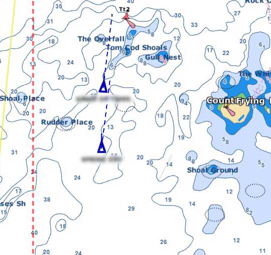
Such a well made point about being seduced into delegating basic seamanship to the software programmer, hydrographer or forecaster. But isn’t the second one simply following the guy ahead, after all “they are about the same size and going close in between the shoals so they must be locals” – or is this too cynical?
Cheers
Rob
Hi Rob,
I think the two boats were friends. Pretty sure neither were local. But even if they had local knowledge aboard I would argue that going that close to a hazard for so little benefit made no sense.
John –
Very sage advice … hope lots of sailors sit up and pay attention. I was a Hydrographer in the 60s and 70s and I show my students how charts were made in those days. And, FWIW, I greatly prefer Official CHS Raster charts.
Hi Dave,
Yes, I think there’s a lot to be said for raster charts. Trouble is that it’s both difficult and expensive to source them for a wide ranging cruise.
I recall that eastbound boats used to trade charts with westbound boats, admittedly tricky in places like Greenland, I assume. Have paper charts fallen so low in terms of common usage that this is no longer the case?
Speaking of cases, I’m having a devil of a time sourcing a chart case, aka “flat file” or “map chest”. I just need a two drawer model, but they are near-impossible to find.
We see this all the time on the ICW. Our track on the navy software goes over land when our eyes tell us we’re in the middle of the channel.
On the weather issue, we used to use six different weather sources to make our go/no go decisions but we recently got turned on to the Storm app by Weather Underground for iOS. It’s a highly sophisticated weather forecasting program that incorporates a lot of the sources we were using before. It has the surface charts, radar, marine forecasts, the NOAA text discussion and a ton more. It also overlays marine charts with a very small optional subscription fee. I recently did a very detailed post on it on our blog with lots of screen prints. I’m just beginning to scratch the surface of this highly capable app. If you’re interested you can see it here:
http://theretirementproject.blogspot.com/2016/01/king-of-weather-apps.html
Deb
S/V Kintala
http://www.theretirementproject.blogspot.com
There is a great article in the current Yachting Monthly magazine (probably March 2016 as we’re in February!) It is all about overlaying satellite images on charts. It recommends all sorts of free/open source software etc. and has a load of instructional detail. I am certainly going to try some of the techniques out when I can find where I’ve put the magazine.
Just be careful of some of that free software, in spite of having virus protection one of those caused me some grief with my computer.
Replying to myself! I have just noticed that the Yachting Monthly article I referred to above is now online. It is titled “How to make navigation safer using satellite images” and can be found at http://www.yachtingmonthly.com/sailing-skills/how-to-make-navigation-safer-using-satellite-images-34665.
Dont do a “Vestas”, forget to zoom in. and check whats there.
Zooming in is just half of the solution. All the zooms in the world won’t help if the maps don’t match what’s out there.
This is why overlaying decent (cloud free) satellite images is so good. When we navigated relative to the land (bearings, transits etc.) it didn’t matter if the charted land wasn’t really where it said it was. But using GPS it very much does – a view from above can provide great reassurance that things are (or are not) as they appear to be! Of course, if the image’s position doesn’t match the chart’s position you then have to work out which, if either, is correct!
Hi Ian,
While I can see a benefit to satellite overlay I think that I still prefer to check chart accuracy the old way with a radar (ok not so old) range and a bearing since that gives me immediate feedback about which way things are off and by how much.
John,
I couldn’t agree more. But geo-positioned satellite images can be used at the planning stage and so potentially give you a good “heads up” on possible problems before you even set off!
Hi Ian,
That makes sense. In the same way I have used satellite images from Google earth in places like Baffin Island, where there is very limited charting, with great success.
Just finished 5 mo. in Mexico and 6 mo transiting Pacific thru to New Zealand. Charts of varying accuracy enroute, with survey data going back to 1800’s (!) – couldn’t trust any on first approach, so usually used eyeball mk1 and radar overlay – but Google Earth overlays were awesome tech to see general accuracy way before getting there. That approach is only useful when you have great internet access – ie not enroute!
interesting sidebar – stopped at Beveridge Reef after Palmerston Isld. Every official chart we could find had note saying reef position was approx 3nm off, and showed no entrance, even Google Earth showed nothing. Had to rely on hand drawn chart generously published by Mr John http://svsoggypaws.com/files/MrJohn-Dangerous%20Middle.pdf
Terrific accuracy, verified by eyeball – example of the amazing data floating around nowadays.
Hi Norm,
Great real world information, thank you. I think we are going to see a lot more really good crowd source charting in the future as plotting software vendors provide the capability to record soundings.