© Attainable Adventure Cruising Ltd and the authors, all rights are reserved.
Nothing on this website or in direct communications received from us, or in our articles in the media, should be construed to mean or imply that offshore voyaging is anything other than potentially hazardous. Dangers such as, but not limited to, extreme weather, cold, ice, lack of help or assistance, gear failure, grounding, and falling overboard could injure or kill you and wreck your boat. Decisions such as, but not limited to, heading offshore, where you go, and how you equip your boat, are yours and yours alone. The information on this web site is based on what has worked for the authors in the past, but that does not mean it will work for you, or that it is the best, or even a good way for you to do things.

I do agree with you: I use a lot Ipad for planning, but never the automatic route . The good seamanship is to plot each WP by hand !In Norway some automatic routes are more than stupid!
Hi John
Your observation concerning “mentally anchoring” is particularly astute. In my reading and observation over the past few years I’ve come to believe that the universal acceptance of the smart phone as the constant companion of everyone under 30 constitutes a new development in the history of human consciousness. Constant users (addicts) form something like a neural link to their digital companions. What they see on their devices becomes accepted as reality to a greater extent than what they observe in the physical world. A person so conditioned finds it natural to rely upon what they see on the screen of a electronic navigational system rather sticking their head out in the cold fog and listening to the real world.
Human minds are constructed so as to create a concept of reality from the partial inputs of their sensory abilities. Hence their age-old tendency to fabricate religions that explain reality in spite of there never being any real substantial evidence to support them. In the course of evolution those who imagined that the saber toothed tiger at the cave mouth was a mere vision didn’t survive as long as those who felt a surge of adrenaline and grabbed a spear. I expect it will be the same with digital navigators who follow the dots through lee shore reefs!
“Digital dopamine: How tech is rewiring our brains”
https://www.futurithmic.com/2019/07/30/digital-dopamine-how-tech-is-rewiring-our-brains/
Hi John
I’m not surprised that almost all sailors who use electronic aids choose to focus upon using them more effectively and none engage in the discussion of the fundamental way we engage and interact with digital information. We are indeed well on the way to becoming a different species—cyborgs who are a combination of human intelligence and digital beings who’s primary sense of reality is grounded in a centralized information control system that is capable of promulgating the most irrational of belief systems. One need only to study the Chinese Social Credit System that is starting to be implemented in the UK and USA, along with the latest crowd control cameras that can search out and isolate a single individual face from a crowd of 10,000 to see where we are going. This article presents a useful introduction to the way the brain sorts information and builds a concept of reality that ignores the rocks and reefs along the way.
https://www.quantamagazine.org/to-pay-attention-the-brain-uses-filters-not-a-spotlight-20190924/?utm_source=pocket-newtab
Well said. I’m late to this, having been actually sailing lately, but even though I have Navionics, I don’t really find this feature appealing. Our motto is “the program can’t swim”; we plot courses in that view and attempt to ascertain local knowledge of potentially dangerous features associated with the shortest routing. Better a few more hours at sea than the terror associated with finding oneself in a washing machine with added rocks.
When I heard of the implementation of auto-routing in Navionics I immediately expressed my view on a Dutch sailing forum: total useless rubbish. You expanded the vocabulary to potential dangerous, rightly so.
100% agree, John. Eyes, ears, local knowledge, and paying attention to what’s happening now are still the best ways of getting from A to B. I have used auto-routing to get an idea of a trip’s distance in the past, but that’s all. The actual trip is always longer.
Hi Kit
About three decades ago I met a Swedish sailor who was one of the first private citizens to winter over in Antarctica on board a boat. At the time I was bemused to hear that he refused to use the radar below at the chart table, arguing that being in the cockpit where he could hear and sense the wave action and smell ice was more reliable. Perhaps he wasn’t as crazy as it sounds!
Hi Richard,
Good point. My thinking is to have the best of both worlds by having the radar on deck.
Also, in the first chapter of our navigation online book I advocate for the importance of situation awareness: https://www.morganscloud.com/2010/03/18/an-old-newfoundland-story/
Hi John,
I think it’s a great feature for providing ideas; where we sail – Moreton Bay, QLD, there are a lot of islands, channels and sand banks, so figuring the shortest route from A to B isn’t always obvious. Generally speaking the weather is not a major consideration as we’ll stay home if it’s blowing over 15-20 knots, so the channel depth is very much the major factor that determines our route, particularly if motoring. That said, I don’t tend to use it for actual at-the-helm navigation and rely on my chartplotter and common sense to action the suggestions worked out at the desk.
Hi All,
Good to hear that we are all on the same page with this: fine for a bit of rough planning, but a bad idea for actual navigation.
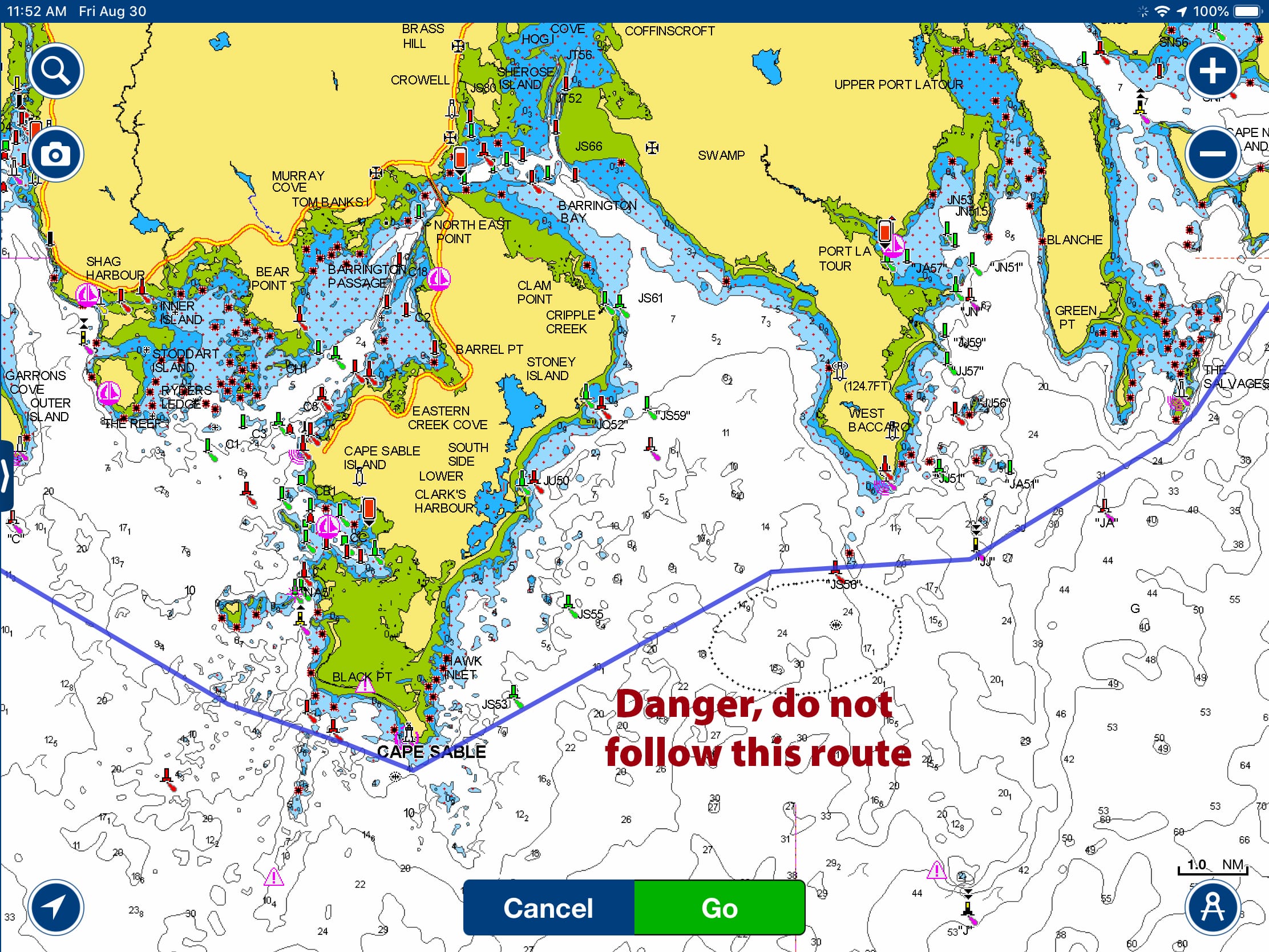
Increasingly, the internet is being designed to tell us what to do. The earliest versions of this were “spellcheck” and the functions that tried to suggest what word you should use next when writing text. Nearly everyone knows the often hilarious results that these “aids” produced. By the same token, anyone who has navigated the various capes and coasts of the world’s oceans and seas must respect the importance of standing clear of unpredictable promontories. Fortunately it seems unlikely that recreational sailors who find themselves rounding Cape Sable would follow the hazardous route suggested by a simpleminded AP. That said, you are correct in decrying the negligence of allowing a product so misleading to be marketed.
Hi John and all,
I am always interested in the “meta” message that some of the new tech brings to the table, often inadvertently.
I have recently had occasion to spend much time in Washington DC where grandchildren and family now reside. I realized at one point, that I was in no way learning my way around, a skill that I am actually pretty good at in new places. I had no need: Google maps was telling me every turn: usually conveyed by Ginger at my side, but sometimes with the phone talking to me. A huge convenience, for sure, but very much at the expense of my ever getting to the point of “knowing” the city or of being able to operate independently around it.
The alternative is to forgo the electronic aid and do things the old-fashioned way: with a paper map and some trial and error, and just tolerating the learning curve. I have yet to go that route. Not sure how this applies directly to route planning except for the clarity and situational awareness I accrue by planning the route on my own.
For me, the above makes me wonder what in the long run, this will mean for spacial mapping skills that are so crucial in all things physical and mechanical.
My best, Dick Stevenson, s/v Alchemy
Yeah, I’ve noticed this a while ago: when I use the GPS app for turn-by-turn navigation, I don’t actually learn my way around. However, using it for planning the route and then following it from the “north-up” view, doesn’t seem to have that negative impact.
Probably something to do with “big-picture” view and spatial awareness.
Dick, you are right that Maps keeps you from “learning the city” – however at the streets there are seldom tidal races or uncharted obstacles 😉
However I remember when I was asked on a highway to “turn around if possible” – and just two weeks ago Maps led me into a pedestrian-only zone in a small Sardinian village with very narrow streets and no possibility to turn around. This told me to reduce my faith in this kind of apps and step back to the old fashioned way, just not with paper maps but Google Maps without routing. At least in places that might be interesting to get to know – I still like it when it tells me the correct highway exits 2 miles in advance.
For navigation I would never blindly follow an autoroute, for all reasons already posted.
Hi Dick,
Good point that by navigating less, on land and sea, we lose the skills to do so. A year or so ago I read an article suggesting that the use of navigation apps was physically changing our brains to the point that we will no longer be able to properly orient ourselves, even if we want to. Scary stuff.
Hi John,
You yourself mentioned in a previous post that you found it easier to use your chartplotter in heading up mode, this is probably a good example of this. I had previously had mine on North up but changed to your recommendation; it sure is easier to work out where you are going and improves situational awareness on a micro level, but I find it means I lose my sense of bearing on a macro level. On balance I think I prefer North up as I like to know where I am in relation to the bigger picture.
It’s insidious, this stuff, and I’m no Luddite. My 76-year-old father-in-law uses a talking GPS on the highway set to “grandpa” volume, even on his way home. He’s not senile, but he’s habitual in this respect….maybe it’s company whilst driving alone? I find it hugely annoying and try to rely on memory, direction and, if needed, paper maps!
For most boaters maritime Auto routing is a “logical” extension of Google maps routing….the forget one little secret. Google maps suggested routes are constantly modified by the speed data automatically collected from hundreds or thousands of cars ahead of you. This is done in the background by Google browser. Try to use Google Maps without Google Browser on your device and you will see what Google Maps app will tell you …..sooo maritime autoroute feature is a complete garbage UNLESS there will be a bunch of boat ahead of your boat proposed route reporting sailing conditions etc. ….But then I rather be flying….
Thanks, but what is the intended audience for this article? Yes, its absolutely correct in everything it says, but surely no properly trained sailor is going to accept the route an electronic App suggests without also considering every aspect of the passage him/herself on either a paper or an expanded electronic chart and also considering the weather? Never mind that an error could kill you and your crew, its part of the discipline, and fun, of cruising to plan the passage, isn’t it? I venture that the real place for this piece is in a basic recreational boating magazine . . . that’s where it’ll save lives!
Hi Peter,
I would venture to suggest never to underestimate the compelling seduction of electronic labor savers and information purveyors.
My best, Dick Stevenson, s/v Alchemy
Hi Peter,
Over many decades of sailing, I’ve been guilty of behaviour far more stupid than accepting a machine proposed route as good. I’ve repeatedly seen many others be just as lame. Knowing better isn’t enough. Being aware isn’t even always enough. It sounds like I think we’re idiots. Well, yes, in some ways we quite literally are.
I’ve ranted about these mental mechanisms in other contexts many times before, like with bike helmets and safety vests. Wearing one of those, or seeing a nice route on the map, will ALWAYS influence our emotions. Our emotions will ALWAYS be an influence on our behaviour. The only way to completely avoid that, is having no emotions, which is a far scarier idea. 🙂 We can be aware of the influence and compensate for it by being rational and double check, but the influence will not disappear, only the consequences, if we stay aware.
The crowd here are mostly highly skilled and experienced, but does that make us less vulnerable to emotional influences? Not at all. The classic insurance claim explanation, from an accident in an area where all houses are similar: “Turning up the wrong driveway, I hit a tree I don’t have.” The driver is probably very skilled at driving up his own driveway, which is exactly why he crashed!
Hi Peter,
I hope you are right. On the other hand, I fear that Stein’s point is valid, particularly since I too have done some deeply stupid stuff.
Very good point that has the potential to save life. Plotting manually a route for a voyage is a process that involve the analysis of all the conditions. It is long a tedious if well done. It is scary to see the tendency of the software developers to ease the life of inexperienced skippers by offering such a dangerous function. Hope people will make good use of it…
For the same reason nearly never plot a course on the multi system display and let the AP follow it. Exception is when on passage and well off the nearest continental shelf.
Yes I do plot the course on the electronics not on paper but run point to point using the autopilot (actually a bit away from nav aids). Similarly when using the apparent wind feature or under the hydrovane use the electronics to remind me /others when we wander too far off course but only as a visual aid. You look at the screen and can see where you are relative to the course. Do this in part to get crew looking at the screen periodically for AIS or radar targets but also to keep VOG in their minds.
Think such behavior may have saved the Volvo boat some grief. But of course you need to be changing magnification routinely when coastal or near land.
Hi Lee,
I 100% agree on not linking plotter and autopilot: https://www.morganscloud.com/2010/12/17/chart-plotters-and-autopilots-never-the-twain-should-meet/
110% agree, John (it’s an Australian joke); the two tools are separate on Seabiscuit for exactly the reasons you give in the linked article. Old school, I know, but our boat changes direction when we decide.
We’ve been doing this all summer, this “not linking” thing. It’s been quite informative in terms of revealing subtle currents and which points of sail produce drift to leeward and which do not. It’s also easier on the autopilot, because sail trim reduces, or can reduce, oversteering.
As John noted in the article, my exposure to the Navionics autorouting function was at the beginning of a run from Maine to Nova Scotia on someone else’s very nice, classic power boat. I was kind of fascinated by it at first but became more than a bit concerned when I realized that the owner/skipper was actually taking it seriously and seemed prepared to follow the line on the screen. To temper the skip-by-the-rocks foolishness, I suggested that we put in a really big number for vessel draft, something like 30 or 50 feet. This resulted in a more sensible offshore route and, after discussion between skipper and crew, we ended up taking a safe and appropriate course outside all dangers. My conclusion was that it’s fun to play with this stuff at home or to kill time on a long watch, but it should not be taken seriously as a basis for decision making.
Thanks for raising this topic.
You might also want to include the newish “automatic weather routing services” like savvy-navvy, which I think are potentially even more concerning and dangerous actively leading the user to believe in false “safety” regarding all weather, wind, and tidal stream data being “accounted for” in addition to chart data and the vessel’s draft.
https://www.savvy-navvy.com/
Hi Angie,
I agree completely and advocate for not using auto routing or at least being very careful if you do: https://www.morganscloud.com/2023/11/17/weather-analysis-hardware-and-software-version-2/
I am just a Coastal Cruiser no off-shore expert but we do have our fair share of hazards along the West Coast.
I like the Navionics app for a few non-mission critical tasks.
I use the Navionics App on my phone for various ‘quick looks’ at remote locations or anchorages when I’m away from the boat… I also use it when out in my Dinghy while putting out a prawn or crab trap.
The Navionics auto-routing function is useful to get a quick idea of how far various possible objectives might be when planning the next day’s run. It’s not uncommon though to find that Navionic’s suggested routes would be ill-advised, so I would not use it for any serious planning.
I use Coastal Explorer to plan my real routes. (IMO it’s a much better interface than Time Zero) I then port the route over to my Time Zero / Furuno MFD via GPX files.
In the end, I will have looked at the route through 3 different displays. In doing so, one is forced to consider each and every leg of the route before setting out.
-evan
Hi Evan,
Sounds like a good system. I have long heard good things about Coastal Explorer, although I have never used it.
I should add that my good wife as “Chief Safety Officer” demands that we have paper Charts open for every part of our route, so we have perhaps 4 different presentations of our route. ( I can think of a few occasions when her questioning my planning has kept us out of trouble…)
-evan
Hi Evan,
Yes, great to have someone else checking navigation. Phyllis has kept us out of trouble too.
Until plotters and electronic charts sold to leisure users meet the International Hydrographic Office standards for data quality and presentation, we should have a healthy degree of chronic unease when using our electronic systems. I have read on forums queries about features on Navionics charts that are not there in real life and vice a versa e.g. rocks and guts that don’t exist. Auto-routing is madness especially if being used complacently.
Hi Alastair,
Good point on chart inaccuracies introduced when government data is transferred to recreational charts. That said, we also need to be aware that not all government data is right either: https://www.morganscloud.com/2016/02/19/one-simple-navigation-and-weather-safety-tip/
Also worth noting that many hydrographic offices only have a mandate to acurately chart for commercial shipping, this is certainly the case in Australia where many areas frequented only by recreational users are completely ignored by the AHO. Navionics and the like are the only available options.
It is really interesting how so many of the pictures marketing these apps show the users concentrating on their device rather than looking at where they are actually sailing. I have also seen this too often even with experienced sailors where they steer by the plotters display, rather than looking outside the cockpit. As with any piloting skill that is becoming increasingly computerized; be it flying, driving, or sailing and power boating, unfortunately we tend to lose basic skills. My first thought when seeing this was that it will be just another notch down on the level of basic skills we should by trying hard to practice and keep sharp. Especially for the new generations of people entering yachting that never learn to pilot without a chart plotter.
I agree – auto routing can be a dangerous tool if used without sound piloting skills and brain that is engaged critically reviewing it.
There is one use case where we have found Navionics autorouting extremely helpful; that is motoring in the ICW. There, planning for opening bridges is crucial; some open on the hour, others on the half hour, others at specific times of day. Before autorouting, we would have to manually create routes between opening bridges waypoint by waypoint as the ICW wound it way north or south. The manual approach inevitably resulting in many “shortcuts” over land when rounding bends in the ICW. Thus, the ETA at a bridge opening was not very accurate. Autorouting eliminates the ICW “bend” issue and yields a fairly accurate ETA. Of course it does not reflect currents, especially around inlets, but the ETA is good enough that we can speed up, or slow down, to have confidence that we will arrive at the bridge when it is scheduled to open.
A second use case for autorouting that we found helpful, was for overall trip planning in areas that are new to us. We were in Nova Scotia, for the first time, this past summer. Frequently, we would look at our paper charts and try to figure out, for example, how far is it between the town of Chester and the Rogues Roost anchorage? Yes, we could walk our dividers across the paper and calculate the distance and estimated time. But, entering a starting point, then a finish waypoint, on the iPad is much quicker and yields the information much faster. Knowing the rough time and distance, we then manually create the route we will follow factoring in safety margins along with current and wind direction.
We’ve found manual route creation in Navionics easier than on any other app or MFD that we have. After the route is created in the Navionics app, it is exported to iNavX which is our primary navigation app and to the RayMarine MFD.
Hi Paul,
That makes sense and is much in line with the way I use autorouting. That said, I just heard of a boat that ran aground because autorouting missed a buoy, so like you, I would never use it to navigate on, even in the waterway.
My boat is presently in the yard being repaired thanks to this feature on Navionics: but the blame is solely mine. I should have checked the auto course more thoroughly, and I should have been more aware of my position on the water.
Auto-routing is only as useful as the user makes it. I was aware of the risks of using this feature, but not aware enough!
Hi Jim,
What a drag. However don’t be too hard on yourself. As I say in the article, phycological anchoring is a fundamental weakness in the way we humans think, so most of us could have made the same error. I know I could.
I used to work for a company that sells routes to commercial ships (mainly oil tankers). The company’s USP is that, unlike all the competition, their routes are created by stitching together legs that have each been manually designed by a master mariner. Obviously this required many person years of work (and more ongoing work to maintain them) but I believe that it is the only safe approach. Even then, the company still makes it very clear to vessel navigators that they must manually review the route before use.
There are other problems with computer generated route legs as well, such as correct TSS handling (even if it is just avoiding the TSS for a small boat) and knowledge of the relevant Notices to Mariners, as well as tides, prevailing wind etc that you have already mentioned.
Hi Andrew,
That’s interesting. Who knew there was such a service. And, I totally agree, the bottom line is that every time we transit a body of water, it’s different.
A better and safer idea to use this technology would be a feature called “Route Audit”. That would take a route you had plotted manually and suggest improvements which you could accept or reject. And an easy way to improve autorouting, which is here to stay, would be to add more options to the configuration, and default them to safe numbers. For example, you could have a setting for “avoid shallows” and set it for a 5 nm radius. For software with access to tide info, you could have a feature for navigating around high tides. Truth is, these autorouting features are primitive today, because they don’t look at enough data to make good decisions, but it’s possible to imagine a world in which they get way better and are able to pay attention to more details. Imagine a situation in which your MFD downloaded new weather data automatically, saw impact on sea state, and alerted you to propose an alternative course. Imagine further a Tesla-style system in which your navigation choices are uploaded to the cloud together with prevailing wind and sea conditions actually experienced in navigating that route and become part of a database which is available to everyone for making better navigation decisions so that a machine learning algorithm can take the collective wisdom of lots of mariners to recommend a course. All of these things will come within the next decade because the technology is there to do it and arguably that technology can making navigation safer. And yet… will it predict the whale in front of you or the floating pallet ? Perhaps when thermal imaging and analysis is good enough to identify objects in the water, but for sure not yet. So keeping watch and paying attention remain important. So… I agree with the sense of the article and comments that the current systems for autorouting are scary (I don’t use them at all because I actually like the process of entering waypoints manually, and my preferred nav app iSailor doesn’t have autorouting as a feature) but what’s wrong is the current implementation rather than the idea itself. Property constructed with first focus on safety rather than convenience, it could be a feature which would keep us safer by analyzing more data than we can properly absorb ourselves. What’s missing for now is the reliable, inexpensive high speed data links which would make some of this possible but even more so the sufficient resources at the MFD producers to incorporate modern machine learning technologies into their products. One thing for sure: as much as everyone should know enough about navigation to be able to navigate with less technology, we shouldn’t run away on principle from better technology which can improve safety….
Tim,
“So keeping watch and paying attention remain important” – at least as far as I am concerned keeping watch, paying attention and physically connect with natures’ peculiarities around us belong to the main reasons why I long to be “out there”. And I am sure that most if not all of the subscribers of this site feel alike.
Hi Ernest,
I would agree. No doubt we could theoretically get to the point that our boats could go sailing without us, but then why bother. Just play a sailing video game instead.
Hi Tim,
While I agree that good autorouting is theoretically possible, I doubt very much that we will ever see it. My guess is that the volume will never get to the point that is will support the level of tech needed.
That said, I like the idea of a route audit module.
Intellegent autorouting and autonomous vessels are not far away at all, semi-autonomous tugs are almost in service, where the only part done by a human will be the actual docking operations, and that human will be in a control room somewhere on-shore. The cost of having crews at sea is a massive driver for autonomous vessels, and for this, accurate autorouting is an absolute requirement. That technology will eventually trickle down to the charplotters and autopilots fitted to sailboats.
Great article, many thanks. It has reinforced my thoughts that I am a very old school individual having sailed in New Zealand waters for more than 65 years. I have not used any form of auto routing though I do of course use a chart plotter.
My approach is a bit time consuming, but as error free as one can get. On every paper chart of our coast I create waypoints that are a minimum of 1 nautical mile clear of the nearest hazard and second ones that 2 nautical miles clear. (1 nautical mile for daylight and 2 nautical miles for night or adverse conditions). I give each of these an alpha number prefixed by the number of the chart, e.g. 532A. All of these waypoints are then entered
into the chart plotter. When plotting a course and also when underway if I wish to sail between two destinations I use my ruler on the paper chart to ensure that my course between each waypoint never enters the danger zone inside a waypoint. If it checks out I sail over or outside an adjacent waypoint and hit GO TO for the next waypoint.
TIme consuming, yes, though New Zealand’s coast is littered with obstacles.
If I do not have an up to date paper chart of an area, I do not sail there.
Hi Peter,
Now that’s a careful system!
Autorouting around the “raz de sein” goes between the “la vieille” lighthouse and the shore. I’m sure there could be a contest about which one would be the most … interesting case!
The fact you can set and add points on the autorouting is good for an assessment of a long trip, but remain a 30k feet overview !
Wow, it’s a lot less sophisticated that I’d have imagined. I’d have thought it would link into a weather forecast system, calculate tidal currents and sea-state from the chart and moon phase, require you to enter your boat’s real-world polars including the effect of sea states (if it hadn’t already learned them), your preferred upper and lower wind-speed limits (wind speed relative to water and taking current into account of course) to plan your route. Guess there’s quite a bit of development required.
Another reason for using Autorouting with caution (especially in areas with lots of traffic): I would much rather not be on the exact same path everyone else is using …
Hi Robert,
We agree: Colin emphasizes that in his series on navigating in fog.