 Here is our report on how the electronic navigation gear on Morgan’s Cloud handled our 10,000-mile, eight-month Arctic voyage:
Morgan’s Cloud—Navigation System Philosophy
Before we dig into our electronics gear, a quick note. Despite having spent some 30 years in the computer industry, marine electronics are a long way down my priority and mind share scale. Way below the rig, engine, deck gear and anchors.
When we do think about electronics, Phyllis and I put reliability and a minimum ten year life span way ahead of the latest wiz-bang features. Heck, we only got off paper charts three years ago, and we still always have the relevant paper chart in the cockpit ready to go.
So if you are looking for information on the latest super-duper, Wi-Fi enabled, iPad controlled, integrated, NEMA 2000 capable system, you may want to head on over to see Ben at Panbo.
Having said that, we do have a system that works well and helps us make the right decisions in some pretty harsh conditions.
Mounting
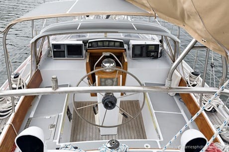
 Before we get into the gear itself you should know that we do all navigation and most communication on deck on Morgan’s Cloud. Over the years, we have moved almost all of the electronics into custom made pods under the dodger, as shown in the picture above.
We believe that this is the only way to go and simply can’t understand why sailboat builders insist on a chart table below and then mount much of the vital electronics there, and in so doing, require the navigator to behave like a demented gopher bouncing up and down through the hatch. Not only is this inconvenient in the places we sail, with a high proportion of fog and ice, it’s dangerous, particularly when short-handed, as we always are. (A good thing about plotters is that they can be easily mounted on deck, which is helping to alleviate this problem.)
Electronic Navigation Hardware
After much thought, we made the decision to install:
- Dell Vostro 1310 Laptop with 15 inch screen, 3GB RAM, Intel Core Duo CPU, 250GB hard disk.
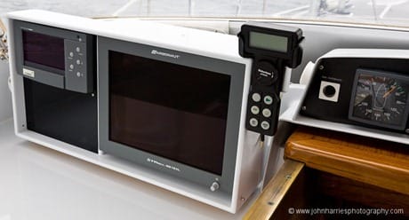
- Tflex-G615XL 15” Sunlight Readable water proof display.
- A water proof mouse and keyboard, designed for medical use where such things must be washed.
- A 4 port serial to USB adapter box.
Before heading north, we did take the precaution of replacing the hard disk in the laptop with a solid state drive, thereby eliminating the one and only critical moving part in the system. We also bought and fully configured a back-up laptop.
The Good
- This system worked well for three years with no failures.
- Even with the backup computer and solid state drive, we ended up spending less than the price of a good plotter, when you take into account that we would need a laptop for email and weather anyway.
The Not So Good
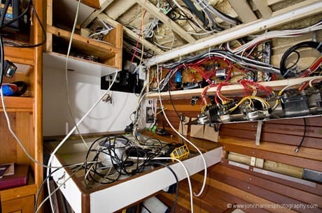
- A good and seamanlike installation of a system like this with the screen, mouse, and keyboard on deck and the computer below is not trivial.
- Ironically, since we have stopped for the winter, the Dell has been flaky in the last couple of weeks—looks like a serious hardware problem. Since laptops are now about half the price we paid for this one, we will probably junk it—after first taking out the solid state drive and installing it in the spare computer—and buy a new spare.
- We only recommend this approach if you are comfortable with computers and software since a certain amount of messing around, upgrading, and trouble shooting is required to install a computer based system and keep it all working well. If the thought of that kind of thing makes you break out in hives, we would recommend a good quality self contained plotter instead.
Verdict
Highly Recommended—but with the above caveat.
Electronic Navigation Software
We decided to go with Nobeltec Admiral after trying out the low cost Digiboat Software On Board and finding it a bit flaky and also difficult to use. (This may have changed in the last three years.)
Nobeltec Admiral is very high end and expensive at $1200, with many features aimed at superyachts that we don’t need. The only reason we bought it was that at the time it was owned by Jeppesen/C-MAP, who we partner with on our Norwegian Cruising Guide, and they cut us a very good and generous deal on the software and associated charts.
The Good
- The current version (11.2) of Admiral is very stable.
- The software has been stable since version 10.2.
- It is very easy and elegant to use.
The Not So Good
- Version 10.0, which we started with, was so flaky and bug ridden that it was down-right dangerous.
- The software requires a copy protection dongle. Lose or break it, and you are down. And I’m guessing that Nobeltec would make you buy the software again if you lost it.
- A year ago, two weeks after we paid Nobeltec (now partially owned by the same company as Maxsea) some $1000 to upgrade to version 11.00 and update our charts to the latest versions, they announced a “new product” that we could switch to for just another $700.00. Oh, and by the way, we would have to buy all new charts for full price too…from them. As I remember, Maxsea pulled a stunt like this some years ago too. That’s not nice, guys. We will use Admiral until Nobeltec stop supporting it, and then switch to a different company.
Verdict
Not Recommended—due to corporate culture.
C-MAP Maxpro Electronic Charts
Maxpro is C-MAP’s high end offering.
The Good
- Much better rendering than most recreational vector electronic charts—a near paper chart look and feel.
- The purchase price includes a year of updates over the internet. This is a huge benefit, since, for the first time, it is practical for a recreational vessel to keep all of their charts fully corrected and up to date at all times. A task that used to be just about a full time job for a junior mate on a commercial vessel.
- In the northern North Atlantic and the Arctic, C-MAP cartography is simply the gold standard; every commercial vessel I have talked to uses C-MAP. No other company has the accuracy and coverage they do.
- C-MAP have done a truly incredible job of correcting the datums on the underlying cartography. In most cases, even in the more remote parts of Greenland, the datum was bang on, even in places where the same government paper chart was as much as half a mile off. This is not a trivial achievement and C-MAP deserves kudos.
The Not So Good
- Much of the embedded harbour information is really pretty useless, although the pictures can sometimes be of benefit. I know that C-MAP are working hard to improve in this area.
- MaxPro charts are more expensive than the lower end offerings from both C-MAP and competitors, a lot more expensive.
- After the first year of free updates, you must pay an annual fee to keep the update service.
Verdict
Highly Recommended—charts that are always up to date are worth paying for.
As always, if you have a question or a tip about navigation gear that has served you well, please leave a comment.


Over a period of 5 years, what do you think your average annual expenses have been for electronics and navigation gear?
Hi Jerry,
A really good question. What use is any of this without a bottom line?
Hum, thinks…counts on fingers…scrawls numbers on back of envelope…about US$1500-$1800 (includes electronic charts and software upgrades) a year over 10-years (the average age of our electronics). Keep in mind that we do all the installation and most repair work ourselves and that we keep our stuff going far longer than most people seem to: Radar 12 years, Autopilot 15 years.
On the other hand, when we do buy, it is often (although not always) top of the line, so more expensive.
Hi John, great article !
About those cool custom pods … are them made of Fiberglass? Where do you get them made?
Tks
Hi Alex,
The starboard one is aluminum and was made by a custom aluminum fabricator. Rather expensive, particularly after it was painted.
So when we needed the starboard one for the electronic navigation system, I made it myself from marine plywood. Copious amounts of epoxy putty masked my bodge carpentry and then Phyllis painted it with one part gloss—much cheaper.
I think your PC based navigation system is very good and much better than many plotter systems.
However I have some remarks: PC harddisks can crash, but some are more resistant to humidity and viberation. I go fore the better ones. How safe a harddisk you want is a money question. Those with no moving parts seems to be the best for a ship in the Arctic.
Adapters from USB to serial are a week point. I do not use any adaptor, but use a correct pc port. It makes failure less possible, and is cheaper.
You seem to love C-map. I do not. C-map is common in the Arctic because free copies are common. That does not mean that the quality is good everywhere. North of 80 degrees C-map has nothing and already by 70 degrees the Mercator projection is bad. Many fisherman have C-map and buy other systems like Olex to get the detailed information. Olex have private datas from very many ships. Most ships sailing in the Arctic have private data of some kind because of the low quality of C-map and others. But they always have the official maps as well.
Wish to you fair winds, Svein.
‘Fraid it does all sound a wee bit expensive for an impoverished Scotsman! What are the advantages of the C-Map Maxpro charts? And can they be shown on a basic 5.6″ VGA plotter?
Just shown some slides and the excellent film of the lads climbing those big walls near Upernavik in Greenland in 2010, at the Fort William Mountain Festival here. Seemed to go down well
just for the record, my 6-yr-old garmin aa-batt-operated chartless handheld gps gives me everything i need for operating my power cruiser along the fl west coast (occasionally do consult basic paper charts for areas new to me although my current array of waypoints accumulated in this time makes this less and less necessary)…let me hasten to add i realize this type of cruising doesn’t begin to compare with gunkholing in your extreme northern areas…but for most of us we can comfortably pass through our cruising grounds with such minimal (yet imminently effective) electronics as this…richard in tampa bay (m/v cavu’s skipper…formerly s/v sidra’s skipper)
Hi Richard,
A very good point. We have a pretty complete system because it helps keep us safe in the challenging places we go, particularly since we are often in thick fog and short handed, where good electronics, properly used, can help ease the pilotage workload, which, in turn, gives us more time to keep a good lookout and maintain our sense of where we are.
But having said that, we would never suggest that everyone on the water, or even most people, need a system like ours.
Never quite sure whether you receive my comments or queries, or how the system works? I see the guy after me got a reply!
Hi Bob,
I kind of felt that I had already covered the advantages/disadvantages of Maxpro charts in the post itself. I doubt that any small plotter, like the one you describe, would run Maxpro charts.
Hi John, I have a question for you on development of seamaps. If you go to olex.no you can see under seafloor maps that ships of the Arctic are giving each other their datas of navigation in a large scale. They are copying each others harddisks, so that if you find a stone in Greenland that is not on the map, everybody wil know it soon. I guess this must improve navigation a lot. Have you tried this? What do you think?
Best regards Svein
Hi Svein,
Yes, I have seen the Olex product, very impressive and the crowd sourcing nature of the data distribution is very cool too. Might be a bit of overkill for the average sailboat though? What is the cost of the software?
Hi John, I think your question is on the target. The price for a yacht version is 2500 US dollars. I think your maps can be used in Olex. But so far I think this is the only way to get map data of my favorit region, Nordaustlandet of Svalbard. The gouvernment has promised to publish maps of Nordaustlandet, but I do not belive it before I see it. My second dreamland, North East Greenland, is also not much covered in Olex (or on Danish maps).
I sail mostly on maps in BSB-format and NV-digital. Here I have shared data with several fishermen with a very good result. I think it is a splended idea to logg eccosounder and GPS in a PC and share it with other sailors of remote regions. And there are cheap software like the German Chart Navigator Pro (Nv-verlag.de). It works well for me. They have an office in Newport, US, and several surveyor ships, even two 50ft Main lobster fisherman of high quality. Those guys know how to sail in on bad places. The maps are very good. The free software I know is OpenCPN. I think it is ok and works on C-map, BSB, Nv-digital and S57. I have tried the version 2.5 with good result and no cost. Maybee soon every uncharted aerea will be covered with good data. But sombody will have to organize it, maybee you? I think you are a clever man.
Fair winds, Svein.
Hi Svein,
Yes, expensive. But then if I were heading for Nordaustlandet again—we were there in 2002, but got stopped by ice at Nord Kapp, I might think that the price was cheaper than hitting a rock! Although, having said that, we have spent a lot of time off the charts, using our Echopilot forward scan sonar, without accident—have come close though.
Hi John,
I think you’ll find that C-Map Max pro cartography only runs in Nobeltec charting software, which sort of puts your recommendations in opposition. On the other hand, I’m pretty sure that the core chart data, like the corrected datum you mentioned, is common to all C-Map formats.
Another thing worth noting is that at least for now Navionics has gotten ahead in terms of data updating. They’re republishing their whole database every day and anyone with a current Gold or Platinum card can update it any time they can stick it in an online PC, no special card reader required. I’ve done it and it works quite well.
Navionics also has a layer of User Generated Data that can be shared just like the chart updates or even more easily on connected mobile devices like iPads. And they just added depth soundings files to what UGC includes, something like what Svein is suggesting.
I like C-Map charts a lot but they have gotten a bit behind in terms of updating and community data. On the other hand, Coastal Explorer — which deserves a try as your next PC charting program — now supports the C-Map Max format.
Hi Ben,
Thanks for the updates, all good information that helps put our experienced based post in a larger context—very useful.
For those that don’t know, Ben runs Panbo, the source for information on marine electronics.
John, it’s Panbo with an “n”…though I don’t know what the word means as the site was named by its Dutch founder back in 2004, and he wouldn’t tell me! And thanks for the plug, though let’s note that marine electronics is way too complex and dynamic for there to be any single source. Boaters like you willing to document long time serious use of the technologies are invaluable.
Oops, I will fix it.
So we are in the same position regarding Nobeltec and Maxsea. Having spoken with a Furuno rep at a recent boat show, I have this to say. FURUNO just rebrand maxsea for the US market as Trident. In doing so they allow (for now) Koden radar to be used. This double marketing must cost, so I suspect that if we all “upgrade” to Maxsea (or Trident in the US, NOBELTEC VERSION) , sooner or later this will be dropped as well, and we will all be expected to pay again to upgrade to just the Furuno Maxsea, and no doubt the Koden (rubbish radar I was assured by the Furuno Rep) will be dropped.
I have spent considerable time recently looking for a good alternative and unfortunately failed. No one else I can find offers multi screen support, and Koden radar.
The other really disappointing aspect of Furuno is their attitude to chart updates. This is now 2 or 3 times a year only and at 50% cost for each up grade.
So if anyone out their has some suggestions for soft ware please lets all hear them.
Rosepoint come close, but they do not support two screens.
Hi Andrew,
I agree completely with you assessment of the situation. In the end, we “upgraded” to Nobeltec Odyssey because, like you, we found it was simply the best solution.
And like you, we have a sneaking suspicion we are about to get screwed again when these guys discontinue Nobeltec in favour of Maxsea. Very frustrating.
I also concur that the Maxsea/Nobeltec chart update policy is primitive and rapaciously priced.
Hello – I’m new on here so first things first – Thank you for the fascinating log of your recent Arctic adventure – a great read and fabulous photos.
Well – I came on here initially because I was pondering over whether to upgrade from my Maxsea programme which we’ve used since around 2006. Attending the webinar hosted by Tz and Digital yacht has been the single most expensive thing I’ve done during lockdown from the dreaded Covid 19. Yes I upgraded to Tz4 and just to complete the package – bought a Digital Yacht Ait 5000 unit.
Reading up something somewhere suggested that my Windows 7 laptop probably would benefit from a switch to Windows 10 – so why not – whats another £70 between friends.
Got it all up and running and oh dear – a bit slow and clunky. Perhaps the hardrive needs to swapped for an SSD and then perhaps a bit more RAM wouldn’t go amiss. Hand into pocket again. Bingo – much quicker! The ‘Ways and Means Committee’ was convened to assess the financial impact of all this – UK National Debt is currently around £2 Trillion so its all a bit relative. Anyway – our family live in Denmark and so we cannot see them at Christmas so there’s at least £1K saved.
Project expenditure justified.
The existing Nav set up on the boat is the product of ‘organic growth’ with which I am sure most boat owners are familiar – the bolting of one thing onto another until the day comes when its hard to recognise where this all began.
We used a Garmin handheld linked to our Icom DSC vhf so that can operate properly.
We used the Maxsea programme with a USB GPS dongle plugged into the laptop so that can also operate properly.
The difficulty – which I never did crack – is that, although the VHF and the laptop are not even socially distanced (around 18″ apart) the two GPS positions displayed differ by several meters. On ‘Battleship Courses’ this has never proved a problem but sliding quietly into tighter anchorages, it could be. I have laboured through many an idle moment to try to get to grips with this but to no avail.
Enter the Digital Yacht AIT unit as a potential resolution to the issue.
My only real problem at the moment is that Scottish border are shut – we live in NorthWest England and the boat is in God’s Country (Argyll) 270 miles away. Ah well – the time will pass and the day will come when a vaccine induced normality will return.
Happy Christmas
John