
There are endless debates on forums about which is the best GRIB viewer. These discussions typically focus on which one of the contenders has the slickest features and/or the coolest display of the data.
But you know what? If we really want to clearly understand the weather that’s coming to a place near us, and particularly to avoid, or at least be ready for, violent weather, none of that matters.
Rather, the most important feature that a GRIB viewer should have is the capability to display these three data sets:
- barometric pressure,
- wind,
- precipitation,
overlaid.
The key point is that most GRIB viewers will display all three, but only a few can display the critical three at the same time.
(It’s also good if we can add wave height, as I have done on the screen above.)
Why It Matters
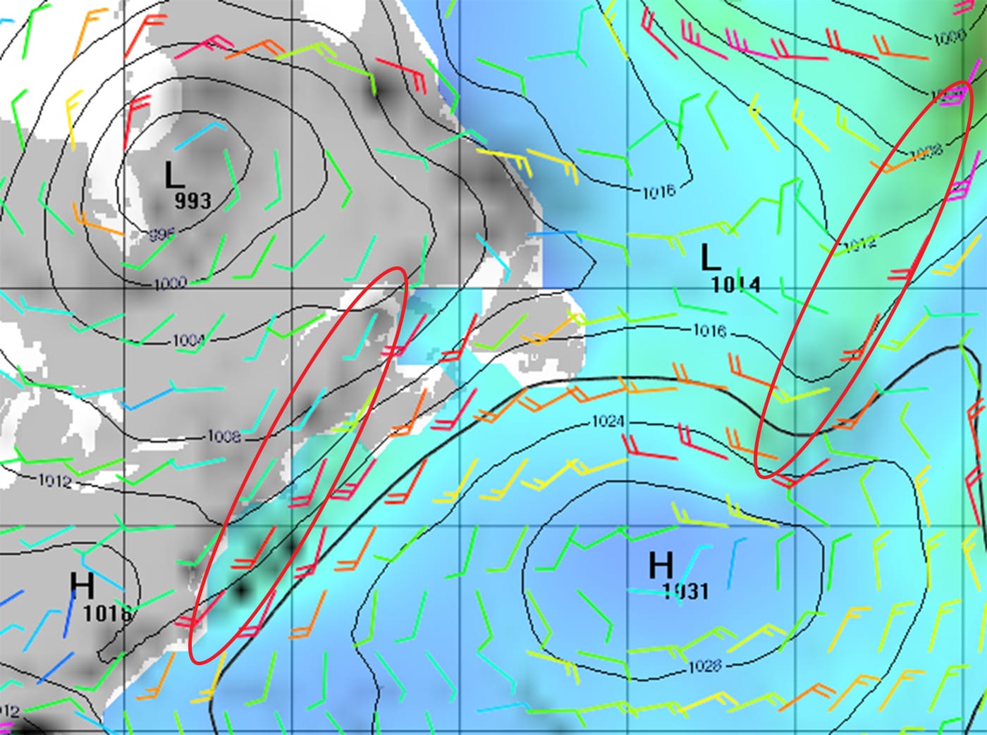
Most really dangerous weather, like violent thunder storms or sudden shifts in wind direction and/or increases in velocity, occur in fronts.
Or, to put it another way, this is the part of a weather system where sudden changes happen that can cause stuff like masts doing centreboard impressions.
And the huge weakness of GRIB files is that they don’t show fronts.
But if we overlay expected precipitation over wind and pressure, apply a little basic weather understanding and practice a little, we can become adept at recognizing fronts.
However, this only works well if we can see all three data sets at the same time. Flicking back and forth does not work very well.
Still The One
This basic requirement is why, despite having looked at several newer and slicker-looking GRIB viewers lately:
- I still like my good old friend Viewfax from the fine folks over at Sailmail.
- And for those of you with tablets, PocketGrib works well and can overlay all the variables on one screen too.
Just another example of the importance of not mistaking sizzle for sausage.
By the way, even if we use a GRIB viewer with the above capabilities, it’s still well worth getting traditional weather maps that show fronts, either by SSB-Weatherfax or over satphone, to sanity check our analysis of frontal positions on the GRIBs.
Here’s the map for the same time as the above GRIB:
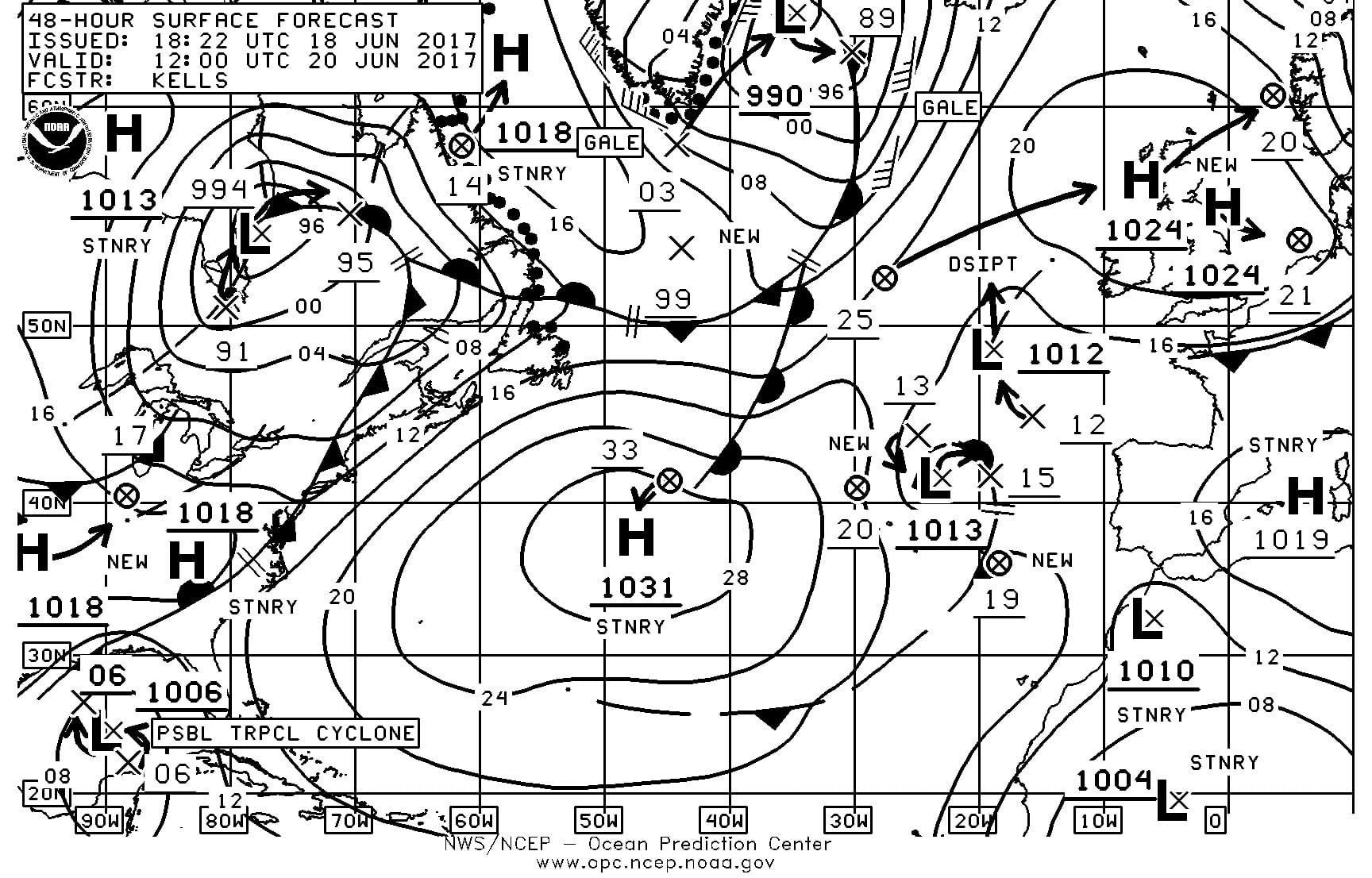
Of course that begs the question: why bother to look for fronts on GRIBs if weather maps show them clearly? Three reasons:
- Most weather maps only extend out 96 hours from forecast time, whereas GRIB files go out for weeks, and modern models are amazingly useful for looking at weather out as much as 10 days from forecast time.
- GRIBs provide a prediction for every three hours rather than every 24 as is common with weather maps.
- GRIBs provide a much higher level of detail than weather maps.
More Coming
I will be taking a fresh look at all things weather over the course of our cruise this summer.
Comments
What’s your favourite GRIB viewer, and why do you like it? And further, has anyone found a viewer for Mac that has the above capabilities? Please leave a comment.
Further Reading
- GRIB viewer comparison
- How to decide if you should pay for weather information or just use the free options
- Much more in our Weather Reception and Analysis Online Book
You and Les Chesneau concur. I took a shallow (because he had to gloss over a lot of things, not because he doesn’t know his stuff) but interesting seminar with him at the last Toronto boat show. I also believe that for some sailors, a daytime part-gale at 30 knots is preferable to a drenching day of 20 knots, and that is the sort of choice you are presented with in the middle of the ocean, so it’s best to know your options.
Hi Marc,
Glad to hear Lee Chesneau comes at it the same way. I’m a huge fan of the guy and particularly the book he did with Chin on using the 500mb reporting and progs.
That book was worth the wading time. I have it too and after I got through it, suddenly all the Jimmy Cornell routing books seemed more doable.
I am using Weather4D 2.0 on iPad / iPhone. Great overlay capabilities.
Hello John and fellow AACs
I also use Weather 4D 2.0 on ipad. A lot of overlays you can choose.
You can also use Arpege small grid when coastal.
It also has a very useful routing integrated. That you can chose parameter to stay in the comfort zone. Thunderstorm prediction useful in the Med.
It is so complete that after three years of use I am still discovering newfeatures.
Close as percect as you can hope.
One draw back if you st for a lot of details the file gets heavy and… expensive if on 4G or sat.
Best regards
Denis
S/Y Hibernia II HR 46
Hi Denis,
Seems like another vote for Weather 4D. That said, I generally prefer to look at weather on a computer and right now I’m totally in love with the LuckGRIB Mac app that another member pointed me too. Looks like my old favourite, Viewfax, might finally have competition.
Use any Android app on a PC with Remix OS including Irid GO.
John, cruising Europe the last 7 years and having cell coverage has made life simpler than the SSB or Satellite. I have always been a big fan of PocketGrib, but lately I feel the upgraded version of PredictWind is very good because you can easily see all 4 models at the same time.
Thanks again,
Jim
Hi Jim,
Predict wind have been kind enough to give us a professional membership, so I will be evaluating it (again) and writing about it over the summer. So far I have only taken a quick look, but did now see a way to display precipitation overlaid on wind and pressure. Am I missing something?
John it’s new for me as well. I know we are pinned down in Gijón and it’s been very accurate as well as our Biscay passage. The ECMWF is very popular here and it seems to be the model of choice. They claim to have the largest super computer in the world with the most data. A lot like Newfoundland reports. LOL
Hi Jim,
Just to clarify, I took an in depth look at Predict Wind a couple of years ago: https://www.morganscloud.com/2016/02/05/five-tips-for-choosing-weather-information-to-believe-and-pay-for/
A key point is that their app for use offshore and their web application work very differently. Anyway, I will be taking another look this summer and updating.
As to the models, we have some thoughts from a pro on that too: https://www.morganscloud.com/2016/03/04/4-great-tips-from-a-professional-meteorologist/
Please note that ZYGrib can display the 3 required parameters at once
thanks Piero
Hi Piero,
Good point, I did take a quick look at ZYGrib but unfortunately the Mac version seems to require a lot of complicated compiling to install it on a Mac. Being a bit techie, I could probably figure it out if I put a enough time into it, but I don’t really see that level of complication as being a good idea, so did not pursue it. Am I missing something?
Hi Piero,
Oops, just realized that the compiling requirement is for PowerPC Macs not Intel. (So much for me being a techie!.) I just installed it on my mac and will have a good look. Thanks for the pointer.
Hi John,
GREAT point, and something I’ve discussed the in the WX article I’m working on for you. Knowing where the fronts were from the GRIBS dictated two major routing decisions we took coming across the Atlantic that proved successful. As a preview to that, I use an iPad onboard running Weather 4D 2.0 – it’s a $50 program, but it does all of what you say above and then some, and is a wonderful tool, which I’ll be going into detail about how I used coming across the Atlantic.
Andy
I’ll go further and say that having a good, CALIBRATED barometer onboard greatly helps all this too – you can very accurately compare your position on the GRIB using pressure, almost like navigating on a chart using depth contours…more on this to follow…
Andy
Hi Andy,
That’s a great point, and something I’ve used all my sailing life – even had a very nice barograph on one big boat I used to skipper. In the old days, when combined with the good old Brit shipping forecast it was a great way to predict the passage of fronts, and with GRIBS it does even better, I’m sure.
Best wishes
Colin
I was very lucky to get a simple recording barometer (runs on four AAAs) for a bottle of rum 15 years ago. It’s called a SpeedTech and they don’t make them anymore, nor have for years, but as far as I can tell, it’s quite accurate and when that downslope gets steep, I double the dock lines! If anyone ever sees one, I strongly recommend buying it.
Hi Andy and Colin,
I agree that a good barometer is required equipment. That said, for the last few years we have been using cheap electronic ones that have proved to be surprisingly accurate.
Hi John,
LuckGrib is a nice Mac app with the ability to display those things at the same time. It’s a relatively new GRIB viewer for Mac that was made to fill the gaps left by previous options. It’s free.
It seems strange that the GRIB viewers don’t have the ability to overlay traditional weather maps over the other data. That would help us weather newbes a lot.
Thanks in advance for the deep dive on this topic. Very timely and helpful.
David
Hi David,
I just downloaded LuckGrib and so far I’m super impressed. Based on a just half an hour of playing with the application I would say that the guy that wrote it (a cruiser) has made a major advance in both functionality and ease of use. I will write more when I have had a chance, over the summer, to use it in the real world. Thanks for the tip.
I use zygrib on linux. It shows the above information (and a lot more). The only annoyance it has for me is that it only shows time in UTC, which can require some confusing math in my head to figure out when it’s talking about in local time.
I also use PocketGrib on my android phone. It also shows the above information.
I have to say though that looking at kinks in the isobars and recognizing them as fronts is a pretty essential skill for anyone using grib files. Comparing gribs to OPC charts is a good way to develop that skill.
Hi Jordan,
I agree that one can often, at least with practice, identify fronts from the kinks in the isobars. That said, it gets way easier if we can see precipitation. For example, the front coming of Cape Hatteras in the above graphics would be easy to miss without precipitation.
By the Way, according to David Burch, the reason why there are no fronts or other annotations like outflow boundaries on GRIB files is because that data does not come out of the supercomputer model. It is drawn by hand by meteorologists from the OPC.
That’s also apparently why OPC charts are raster. You’d think they could switch to a vector drawing program.
Total novice with GRIB files but it seems to me that igrib, on the iPad, displays all three parameters. Wish iNavX did as well.
Michael
Not sure if you’re going to cover this in a later post, but all this ‘which app’ and ‘what to read’ is moot if I don’t know what to do with the data to start with. I’m an inland lake prairie sailor but would like to learn about this weather stuff, but there seems to be some bridge that I’m not finding. It is easy to find the ‘the little arm with the flags means x’ noob stuff and then the discussions like these where the experienced guys quibble around the fine print in something they clearly understand. What’s a person supposed to do to move from weather noob to non-noob? And, can this even be done if you’re not bobbing around in the ocean?
I’d like to learn, but haven’t found they key yet.
Marvin
Hi Marvin,
How about starting off with reading our Weather Reception and Analysis online book: https://www.morganscloud.com/category/weather/book-weather-analysis/
And then I would recommend doing the Starpath Weather Trainer course: https://www.starpath.com/catalog/courses/1804bc.htm
Adding to John’s post about Starpath. The book Modern Marine Weather, written by the same guy who made the weather trainer is a first-rate introduction to weather forecasting for any sailor.
@Marvin: my 2 cents: It took me about 3 years to get the head out of the water! A lot of reading about weather, and if you are like me, because this is not easy stuff, re-reading. Then add some daily practice, like viewing weather map from OPC for instance and cross compare with GRIB files using a good GRIB viewer. Try to know what you are looking for rather than just viewing.
I did a Lee Chesneau’s seminars and his modern approach on using the 500mb chart with surface chart helped a lot in adding the bar to the T. Every sailor serious about weather should attend one of his seminar. Lee recommends also a minimum of continuous daily home work for 30 days to develop some know how.
To link the theory with the practice (there is not much literature about this) a good practice for me now is to contribute routing some friends when they are doing some passage: they send me their daily position and observation and from land, with access to all that data I can practice over real case scenario. I am presently helping routing 2 boats across the Atlantic (W->E) as my current daily routine, and since I am not expert yet this takes me close to 2 hours every day to compose a report for them.
The traditional weather chart is always valuable. Could you spell out exactly the syntax you use to request the MSL analysis/prognosis chart via Iridium please. I am familiar with requesting grib files. Thank you.
Hi David,
There are a variety of ways to download weather fax charts via internet or eMail as well as FTP. Sounds like a good subject for a new chapter in our online book. I will put that on the schedule. In the mean time, if you download Viewfax from saildocs, they have a weather product picker that will save you messing with syntax. UUPlus has the same built into their email program.
Hi John,
All of the PredictWind platforms can show “precipitation” (rain), barometric pressure and wind, in the rain maps. If you use the weather routing in the any of the Apps or web including the PredictWind Offshore App you can have those 3 variables showing along with your weather route data. So at any point on your route you can see wind, current, wave (height,period,direction, with the rain map. i could post some pics if you have that ability on here?
Hi Nick,
Sounds good, I will be taking another look at PW over the summer.
And sorry, we don’t have a way to post images. I have looked at this from time to time, but the problem is the huge performance hit that comment images carry with them because most people don’t optimize images for the web before posting them. OK on a forum with just a few users, but not good on a site like this.
SailGrib WF
Nema data interface over wifi
Irid Go linked for file retreval via email
Access on PC with Remix OS
Many more features including open source ITunes free developer that responds to your email
Hard to beat for the price
Ed