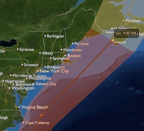
It is now pretty likely that Hurricane Earl will give us high winds here on the south-western shore of Nova Scotia. However, a deviation of just 50 miles either side of the forecast track will likely make the difference between us experiencing gale force versus hurricane force winds. And that in turn will determine whether we do very little preparation on Morgan’s Cloud or a lot.
That brings me to the subject of this post: the danger of relying too much on the many sites on the internet that repackage the information generated by the US National Hurricane Center in visually appealing ways (sizzle) but in so doing, lose much of the really important information (sausage).
For example, someone living in New York with a boat in one of the comparatively open mooring fields of Long Island Sound who took a quick glance at StormPulse this morning (Wednesday), could be forgiven for assuming that he or she had little to fear from Earl.

But a careful read of the NHC forecast discussion for the same time yields a very different picture of the risk to that person’s boat (the emphasis is mine):
“…THE TRACK GUIDANCE IS IN GOOD AGREEMENT WITH THIS SCENARIO. HOWEVER…THERE ARE SOME SMALL DIFFERENCE IN THE MODEL GUIDANCE THAT COULD HAVE LARGE IMPLICATIONS IN TERMS OF IMPACTS…
…THE GFDN…NOGAPS…AND UKMET FORECAST THE CENTER TO PASS NEAR OR OVER THE NORTH CAROLINA COAST AND NEW ENGLAND. THE OTHER MODELS ARE FARTHER TO THE EAST…KEEPING THE CENTER OFFSHORE…”
…THE INTENSITY FORECAST IS A CONUNDRUM. ON THE FAVORABLE SIDE…THE HURRICANE IS OVER VERY WARM SEA SURFACE TEMPERATURES…HAS GOOD CIRRUS OUTFLOW IN ALL DIRECTIONS EXCEPT TO THE SOUTH…AND HAS A GOOD CONVECTIVE STRUCTURE. ON THE NEGATIVE SIDE…EARL IS EXPERIENCING 15-20 KT OF SOUTHWESTERLY VERTICAL WIND SHEAR…”
The point of all this is not who is right or wrong, or even what actually happens in the next few days. Rather the take-away for me is that in this modern world where we are constantly exposed to really slick ways to display data, we must also understand that by definition that very slickness can result in the loss of vital information. In this case, the forecaster’s concern that a small, and quite possible, deviation from the models could result in millions more people being exposed to the devastation of a category four hurricane.

Prepare for the worst, and hope for the best!
It is easy to forget, when presented with a slick animated graphic of storm tracks and radar readings, that we simply do not have the ability to predict exactly what will happen. The best we can do is to estimate the most likely scenario and the uncertainty inherent in our guess.
It’s not uncommon for me to find that four or five weather forecasts for my region, all based on the same readings and model data, will start to deviate dramatically from each other a day or two down the road. Only a few of them will include the critical “note from the meteorologist” that you’ve highlighted here.
A pretty girl standing in a storm with a microphone and some CGI overlays is not a weather forecast. That same girl, sitting at her desk with a dozen model runs and current-conditions maps on the computer screens and a couple of other meteorologists to share ideas with, is what I think many of us would prefer in our evening weather reports.
Hi John,
Great educational article, as usual. We look forward to the e-mail alerts from “Attainable Adventure Cruising”.
At times like this I find the Buoyweather 7-day graphical wind & wave forecast superb. You immediately get a sense of when and how quickly the wind will increase. The wind direction, and how it is expected to clock, is also easy to see. Expected gust speeds are shown. Of course one has to be mindful that it is the trends that are important and that the actuals (timing, max wind speeds, direction) can change as the storm gets closer. In addition, the virtual buoy I use (off the west coast of Newfoundland) is 15 miles from my inland location, so I have to compensate for the effect of local conditions.
Thanks for the “stormpulse” link. The “forecast models” feature is indeed very useful.
Regards,
Norris
p.s. Any plans on publishing a book similar to Nigel Calder’s “The Cruising Handbook” or Beth Leonard’s “The Voyager’s Handbook”? Those books are great references but I find the info on your website to be as good or better – easy to read, more practical and focused (i.e. articles on anchors).
Hi Norris,
Thanks for the kind words and links.
As to a book. With 400 pages on the web, we kind of feel like we have already written one! 🙂
This new web site is the first of several steps we are planning to make our content more accessible and book-like while still taking advantage of the new technologies to keep it timely and relevant.
So, no plans for a paper book at present.
Look for eBooks and support for readers like Kindle and iPad in the future.
The passage of Earl highlighted another problem I have observed in recent years. Once the hurricane gets reasonably close to your position NOAA stops updating the actual position, track, etc., on NOAA weather radio, at least in southern New England. All you get is constant harping about how you should conclude your preparations, head to high ground, etc. That is all well and good for someone who plans on securing their boat and then leaving it. Those of us on larger voyaging boats want to know the latest track and position, so we can properly position our various anchors, docklines, etc. for the likely change in wind direction, etc. You don’t even get an update on the likely wind force or rainfall, so you are completely in the dark relying on NOAA weather radio. I found that the local TV weather was really the best at giving me constant updates on exactly what was happening. I have noted this in other storms in recent years too.
Hi John K,
A really good point. I ranted and raved about the problem here.
We have found the best answer is to have internet access through cell phone to track the storm since the NOAA sites are still updated, even though the information is not being broadcast — go figure.
Hope hurricane Lee doesn’t affect you. Not looking good though.
Hi John,
Thanks for your concern. Right now we are just outside the hurricane zone, but will likely see tropical storm force. Anyway, we are all snugged down. On our side I think storm surge will be a bigger problem than wind, but we are in a sheltered inlet and 75 feet above high water mark, so hopefully that won’t be a problem although I fear for others in more sea exposed places on this shore.