
As many of you know, Morgan’s Cloud is spending the winter in the water this year. This has, shall we say, focused me on the weather and the best ways of deciding what precautions we need to take for each winter storm, up to and including sleeping on the boat, which I have done twice so far. (Yeah I know, anal-retentive, what was your first clue?)
Anyway, the process has got me using a lot of weather resources on a regular basis. But no, this is not a comparative article to pick the best resource, but rather a set of guidelines that I have developed over some 35 years of being a weather-freak that will be useful as you decide what weather resources to use (and pay for) and how much weight to credit to each.
Thanks for this. This is quite relevant since I have just purchased an Iridium Go for the purpose of weather forecasts when we set off on our circumnavigation in April from the UK!
You reference Predict Wind which is simple enough as it is a “service” accessible via their App / program. However GFS which is a model, how would one go about getting that forecast via a very low bandwidth sat system like the Iridium Go? I think it tops out at around 5kbs.
Hi Tim,
The GFS and many other models are available through sailmail and saildocs and that solution works well with the GO!
I think that’s part of the puzzle. When one is tied into a winter berth, both the resources and the consequences of a screw-up differ in quantity and relevance. Offshore, you can get reasonably adept, with instruction and experience, at reading GRIBs and interpreting the 500 mb chart as it pertains to your course. I recently attended a Lee Chesneau seminar and it was interesting listening to the three or four people out of 60 or so in attendance who made little “oh, crap” noises when a “weather bomb in the making” isobar slide was shown.
Even 12 hours’ notice of getting kicked should generally be enough to dictate your course of action offshore, and being your own weather forecaster is to my mind, more seamanlike than hiring a custom forecaster for a cruiser. Were I a racer, however, especially offshore, I wouldn’t hesitate to hire a forecaster, because unless it’s survival conditions, we aren’t stopping and heaving to…we are always going to bash or run unless the boat or crew fails.
Hi Marc,
Speaking as someone who has been caught offshore in a rapidly intensifying low (bomb) I can tell you that I don’t wish to repeat that experience ever again. And I too make whimpering noises when I see one on a weather map.
Therefore I’m interested in weather not 12 hours out but as much as 5 days and using this information I have successfully avoided, or at least ameliorated, a repeat bomb performance over some 30 years and in excess of 100,000 miles.
Bottom line, for me only thinking out 12 hours is no where near enough.
Not enough, no, but better than looking behind you and asking “what’s the dark grey line?”
I was exaggerating for effect; even weather bombs can be, if not predicted, at least suggested, some time in advance, but not usually five days.
One of the more instructive examples of “rapid development not forecast” I can recall is the Queen’s Birthday Storm of 1994.
Hi Marc,
Hi Marc
In my experience the latest version of GFS (2015) will give you pretty good idea of what a bomb will do four and even five days out. This advanced warning will give even a slow moving sailboat time to at least make sure she is on the safe side of said storm.
While I agree that studying weather events like the Queens Birthday Storm and the 79 Fastnet is a useful exercise, drawing the conclusion that looking further out is not worth it from those storms is not. Models have improved hugely from those days, particularly at forecasting bombs.
If you have a GO!, I feel the best approach is to bite the bullet and pay the $128US/month for unlimited text and Email.
We did this for 5 months from Scotland to the Caribbean, in 2016/7, stopping only when we hauled-out for the summer in Grenada.
We got lots of GRIB data, including the rain, swell etc, since the marginal cost was zero.
We happily downloaded GRIBs for wide areas, again because of no-cost.
We also had lots of social Email.
We did not use the free minutes for voice calling, because the recipient gets hit with anything from about $3 to $10 a minute. (I did have fun using my free voice minutes to fight with T-Mobile over an abusively large mobile phone bill that arrived as we left the Cape Verdes. I do not care what it cost them to answer)
The GO! sent a text message of our position and speed every hour, again at no cost.
I am just home from crossing with the ARC Europe in another boat, equipped with an Iridium phone, paying by the minute. The skipper limited himself to one, fairly small area, GRIB/day, receiving the (rather disappointing) weather forecasts from the ARC, and half a dozed very short personal emails. His average cost/month was slightly more than ours, but he missed all the advantages we had.
Hi Neil,
Thanks for the update and confirmation of our position that a GO! is only worth while if one buys the unlimited package. Just to clarify for others, the important thing to understand is that the GO! is actually substantially slower for data than a hand set using UUplus and RUDICS so if one is not planning to buy an unlimited package a handset makes more sense and also solves the problem of the person you are calling being charged and therefore potentially refusing your call.
More here: https://www.morganscloud.com/2016/03/24/the-ultimate-guide-to-using-iridium-handsets-and-go/
https://www.morganscloud.com/2017/02/03/iridium-update/
Thanks for this update John. I am still using UUPLus, Saildocs and Viewfax after all these years having learned about it from your writing and I have seen no reason to change. The ultimate low bandwidth/low cost solution. I crosscheck it with the pinpoint virtual weather buoy concept provided by Buoyweather, another application suited for sat phones (mostly GFS) depending on where you are and many times incredibly accurate. This one costs $79.95 per year. So far, so good.
And let us not forget good old Passageweather (GFS), still the go to website for those of us sitting at the quay (with wifi) waiting for a weather window.
All the best,
Jim
Hi Jim,
That’s great, as long as one realizes (as you do) that all three sources are the same thing said a different way so no actual cross checking is being done, one is 100% relying on the accuracy of the GFS.
I agree. Wrong choice of words and I should have been more precise. The Buoyweather text Passage Forecast for the location of where you hope to be as each day of your passage progresses for up to seven days is a convenient and inexpensive way of distilling a small scale map down to your location (and, at local time). Models other than GFS are available but I have not used them.
Hi Jim,
Absolutely, I have no problem with a service that charges a reasonable amount for packaging government data in convenient ways. What get’s up my nose is services that charge much more than $80.00/year for what is simply free data that costs them nothing and that they add no value to.
Have you considered Sirius XM Marine weather service?
Hi Myles,
I played around with Sirius weather for an hour or so on a friends commercial fishing boat (he loves it) but don’t have any real experience. Of course one issue is the coverage area, which is limited. Also, I’m guessing that the underlying data is the GFS, although I don’t know that.
Hi Myles,
I took a quick look at the Sirus XM Marine weather service and it looks pricy (600/year) to me for what it is (repackaged government data). And then if you are going offshore and/or want comms you are going to need an email service and hardware (sat or SSB) on top of that. And then you need the Sirus hardware on top of that.
I just can’t see the value here, except maybe for those that will stay near-coastal. And if you are going to do that, a tethered cell phone will get you way more benefit.
Yep, I have to agree…and when I had a question for customer support it was not impressive.
I was excited about this option until I realized it had limited coverage. It’s a great idea – constant streaming of high-fidelity weather data via satellite – with some interesting possibilities relative to low-bandwidth options like sat phone and SSB. But it would require worldwide satellite coverage to be truly valuable to cruisers.
Hi John,
Here is my two cents on this topic. On board Haiyou, our Garcia Exploration 45, we use a variety of forecasting tools, but the one we come back to most often is the Weather4d app from Olivier Bouyssou. John hold on… I know what you are thinking, keep reading please. In addition to the sexy visual effect you refer to in your post, it also offers a choice of various forecasting model ( 16 in all- but some might be different version of the same) including GFS and GEM , but also Arpege ( for a fee) and a number of other one I have never heard of : NAM, Arome, WFR. All can be downloaded through our iridium while offshore.
However when we are close enough to shore to get a mobile/wifi connection we always check the local marine weather forecast and more often than not it is the most accurate. This was proved to us once again last autumn when we were looking for a 3-day window to sail back from Western Norway to Holland. While all the models were consistent in forecasting the major lows moving in succession to the north of us, they were, it seems, incapable of forecasting the secondary lows developing in the North Sea with previsions changing wildly every 6 or 12 hours. In the end we relied on the Norway met office forecast at http://www.yr.no which was spot on and we enjoyed a fast broad reach to Ijmuiden.
I suspect some of the answers might also have been buried in the 500 mb weather chart and I have on my to do list to learn how to interpret these.
Best Regards
Chris
Hi Chris,
Weather4d sounds great and is new to me, I will look into it, thank you.
And you make a good point about the importance of getting and using official forecasts as well as GRIBs.
I too noticed that the forecasts from Norway were great.
Hi Chris,
Just took a look at Weather 4d and they are very open about where they get there data (refreshing): GFS FNOMC (US military) and good old saildocs (part of sailmail).
Now I need to look at what models they provide for a fee and what the coverage areas are.
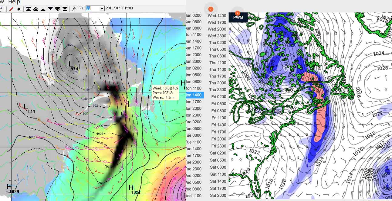
PredictWind Grib Offshore does indeed include GFS (and CMC) in addition to their PWG and PWC. In addition to being able to check multiple models, another big advantage to me is that PWG and PWC optionally forecast Swell. Without swell each model is for 5 days about 7.1kB, and swell adds 22.6kB. A 3 day forecast is about 2/3 of that.
(GRIB HiRes, which is much more data intensive is in only PWG and PWC.)
Maybe you can look at a traditional GRIB and completely visualize, but PredictWind’s animated colored representations sure make visualization easy.
I should add that example was for 6 hour interval 100km resolution and a 400x600nm area, both of which affect the amount of data. I generally like to do a much larger area at 24 hr interval for 7+ days to see what is coming, and then a small area at 50km resolution to see local details.
Hi Rusty,
As you say, and I say in the post, there’s a lot to like in Predict wind. I particularly like the ability to display four models on the same screen just by clicking a button to change between them.
One point though, the swell forecasts are not exclusive to predict wind. The GFS has swell as one of it’s data sets and there are other ways to download swell models.
Also, there are plenty of other GRIB viewers (some that are free) that provide colour animation.
We have used the Predictwind iridium Go package on our recent trip to New Caledonia and back. The Predictwind iPad app is really good, but you can only use with good internet. When you are using the low satellite bandwidth of the Go you need to use the Predictwind offshore app on a PC. This software is really buggy and quite annoying. Although it allows you to download grib files you can’t actually view them graphically in the app so need to use other software to view. Having said that, once you figure out your way around the horrible user interface the routing, departure planning and destination forecast functions are quite good. The routing appears to have at least one major bug tho as it seems to round polar speeds up to the nearest knot? It is a great pity that Predictwind have not invested in fixing the many obvious flaws in the PC software.
Another major negative is that based on my experience and that of a friend with the same package predictwind appeared to change something in their grib file download format a few months ago, such that the downloads stopped working. The only solution I found was to upgrade the PC software, which is impossible when you are at sea, this must have left many users in the lurch which is really poor practice for effectively a safety service provider.
Bruce
Hi Bruce,
Thanks for the in use review, always the best kind.
The good news is that the PW offshore app now includes a GRIB viewer, the bad news is that it is obviously version 1 software and is still buggy, still Jon assures me they are working on it. I do get the sense that maybe PW is trying to do too many things at once: internet version, ipad, PC, GRIB viewer, maintain their own model, etc. My suggestion would be that they drop some products and focus on the remaining ones including the offshore app.
…Bet you had to sleep on the boat again last night John! good blow…
Hi Ben,
Certainly did, mainly because of the very high tide since we are alongside a fixed wharf.
I just used PW on an Iridium Go for 7000 miles crossing the Indian Ocean West to East from South Africa to Malaysia.
Here are some thoughts Ill try to limit them to PW and not the Iridium Go though they go hand in hand.
I like the offshore app with the built in GBIB viewer. As John commented, being able to look at 4 different models at once is pretty cool
A ton of useful info can be garnered from the weather routing data. Wind /current/ swell etc. Downloading just this is the fraction of the size of the GRIBS
The offshore app is pretty buggy. Often downloaded files and data would be missing so you would have to download them again. PW and Offshore APP requires a lot of time to really navigate around it and learn how to use it. Its not super intuitive and the tutorial videos IMO aren’t that great.
The down loading interface is slow. Even with the Firmware update for the Go. I f you haven’t updated the firmware, forget about it. Its about useless. (Bruce – I imagine your friend had the old GO firmware). I cant tell you the amount of times that I had to go back to the computer and restart the GRIB download. Its a good thing you have lots of time at sea!
I found you really had to play around with the size of the GRIB you chose, to optimize for downloading time. If you were using the offshore APP with a sat-phone/modem instead of the Iridium GO (I had the unlimited data subscription for this trip) it would be VERY expensive.
If you don’t have a production boat the routing / departure features are not accurate. You need to be able to plug in boat polars. If you cant do this, the APP puts in Generic polars, but the 1,2,3,5 day routing models are not accurate at all. I emailed the designer of my boat and he responded by saying he had never calculated polars for his designs.
What I found really interesting, was that The PWG/PWC/GFS were usually pretty similar in forecast models but consistently the CMC model was significantly different.
Almost always ALL MODELS under forecasted winds in the Indian Ocean.
You can not view ocean current GRIB’s in the built in GRIB Viewer. This would have been really useful to us in the Mozambique channel and just north equator where we were chasing / avoiding extreme currents between Maldives to Sumatra. You can down load the ocean current GRIB, but then need to save and view it in an external GRIB viewer. I didn’t have a GRIB viewer on my MAC that could display current gribs.
One thing I would like to have seen is a feature like saildocs to send an email and have the GRIBS emailed to you.. Why you ask? Well my at sea email was on the GO and the only way to access email unless you pay for a third party email program is via the tablet interface on the GO. This would have allowed me to get all of PW 4 models and the view them on a third party grib viewer on the Ipad. This would have been handy for multiple reasons.
The Ipad offshore app with a built in Grib viewer that works with the Go was released in January while we were at sea. Unfortunate the APP Store was blocked in the Maldives and I couldnt download it for the passage. From what I was told the Ipad app addresses a couple of my gripes. Specifically it uses the Iridium Go mail protocol to download data which I have been told is much faster. We arrived in Langkawi after 18 days at sea on the 29 of January and I wasn’t bothered to download and play with the APP before my subscription ran out Feb 1
I will say the support from PW is awesome. Every email was answered in a very timely manner to all my stupid questions. PW takes the cake for customer support IMO.
Would I pay for the Pro Subscription again for a trip of that length.? Maybe. Someone else on the internet put it well lately “ It feels like we are beta testers” – referring to the Iridium Go and PW. I tend to agree.
I would consider purchasing the subscription again if I got to play with the tablet version (which I think is the future for PW and other services) first with the pro subscription first. I’d factor in operational area. If operating in an extremely remote austere environment there is some real benefit of seeing all models and extra data that comes with the PW pro subscription.
In the end I think it is important to realize that everything you are presented with is a “model”. You have to be able to interpret the data, and the actual observed conditions at the time to make good decisions. Money may be better spent by many cruising sailors on weather /meteorological workshop or training learning on how to really interpret and understand the wx product data. There is also no good substitute for local knowledge and experience.
90% of the weather information provided using a paid service can be obtained for free using Saildocs and a free GRIB viewer for the Ipad like Pocket Grib.
Regards
Barry
Hi Barry,
Brilliant comment with tons of great real world information. Thank you so much. I would agree with all of your conclusions.
Hi Barry,
Thanks for your write up – really helpful and interesting. We are considering the same GO and PW combo for our trip to the Islands next year. The GO seems attractively priced with the unlimited data plan and I already subscribe to the coastal PW service ($20 pa). I have also found Jon Bilger really helpful, and ready to engage with his users.
One question – you say above: “Almost always ALL MODELS under forecasted winds…”. Does this mean the average wind speed was greater than forecasted, or the gusts you were experiencing were greater than expected? I always add 20->50% to the wind forecast allowing for gusts (depending on whether we are in stable or unstable air), as the models predict mean wind speed, yes?
I had the same experience as you Barry a few years ago when we first started using PW. I emailed Jon requesting a “gust” feature, based upon the data in his weather model (rather than me arbitrarily holding up a wet finger and adding 20->50%) ! He managed to add this within a few months and I have regularly logged my experience and found the PW gust feature (1 row in the forecast tables) pretty accurate since.
kind regards,
Rob
Hi Rob
Average wind speed was always underpredicited in our passages.
05/ was often 5-10.
10 was regularly 15
15-20 was 25-30
Oh 0 was typically 0 ):
Forecasted wind direction and trending in general was spot on. We noticed it was usually off time wise from the forecast by several hours (late)
Jon and his team are great and his product is good. Their support is second to none. Jon is engaged and he really cares, something I have found extremely rare in the marine industry so far.
“Sat-fi” centric communication are the future for anyone who operates in remote environments for prolonged periods of time; PERIOD. This especially holds true for data and weather product info (I’m not interested in a debate regarding ssb/ pactor/etc). The fact that Sailmail has started to develop and introduce interfaces for the GO says it all right there.
IMO the challenge for paid services in the future will be to keep up with the free apps that use the same free GFS data as the base for their products. At the moment the free products (or cheap apps) just don’t have the same graphical/animation/presentation or ease of interfacing of features/communications that PW wind does. At the moment its about convenience. I see that changing quickly as the advancement in these free app’s in the last 12 months has been amazing.
Make sure you buy install the external antenna with the GO and purchase several extra batteries. I just started to sift through John’s SSB VS Satphone article and comment thread. Whoa…. may take me a bit to digest some of that but Ill post some use comments/ observations on the GO over there in a day or two.
Barry
Hi Barry,
You are of course right that GRIBs seem to under-forecast the wind. The key to this is that most are not forecasting gusts, rather than actual inaccuracy.
The GFS now includes gust forecasting, but unfortunately most GRIB viewers don’t display that data. I think that will change.
Also, I would disagree that PW’s viewer is better than the free ones. I have been using both PW and Viewfax from Sailmail and have found Viewfax generally better and more mature than PW. For example Viewfak allows you to read out a point windspeed just by hovering over said point, a capability that PW does not have yet, although Jon assures me they will add it in the next update.
In fact, I at least, find PW GRIB viewer more than a bit crude when compared to several of the free offerings. On the other hand the PW viewer does have the great feature of being able to display 3 models to compare at a click of a button. (I say three models because the two PW models are really the same thing with different initialization data.)
Sounds great. My exposure to the free products has been fairly limited. Looking forward to an article comparing products! All ways up for learning , osbserving and discovering ways that work better , easier to use and more efficient .
@ Barry – “Make sure you buy install the external antenna with the GO”
I have just got my Go and have an existing Thrane Sat antenna with the usual TNC connectors at each end. Have you got the “official” Iridium antenna and / or know of anyone that has had success using a different kind of passive sat antenna?
Another thing is the TS9 – TNC(f) cable from Irdium. $40 they want when you can get them on ebay for $5!
Hi Barry,
Thanks for your in depth answer. Sorry for my late response – I was considering what you had observed as I was somewhat surprised with your findings and that it wasn’t explained by gusts.
I can’t understand why Predict Wind’s model would be consistently under-forecasting average wind strength offshore. What I observe using the service around coastal NZ (which is challenging to forecast) is, the average wind strength and gusts are mainly within the PWG and PWC forecasted range. And when they are wrong, they can be completely wrong certainly if a number of days out – but not consistently wrong!
Why should our coastal set of observations with all their inherent geographical and meteorological influences be more accurate than an offshore set, with few such variables?
Does this then indicate that the Indian Ocean data sets in general are inaccurate, or that offshore data sets are less reliable than “first-world” coastal ones, perhaps due to fewer or poorer manned / automated weather monitoring stations in these areas?
My own limited offshore experience with PredictWind was one yacht delivery last year from NZ to Tonga. I recall the wind ranges to be pretty accurate, even down to the timing of a front and 180 degree wind change.
John or anyone else, do you have a further view / experience?
Rob
Hi Rob,
See my reply to Barry above on gusting. I think that this is the reason that many sailors thing that GRIBs consistently under-read. For example, last night we had a strong gale through here. The forecast windspeed from the GFS topped out at 38 knots in the harbour approaches but the gust forcast topped at 59 knots!
Most sailors only get the forecasts without gusts.
Further most sailors don’t take a lot of time to understand what weather patterns will be very gusty (those with a lot of vertical mixing).
We have very recently set up a Pactor Modem to be used through the HF Radio. This method does not seem to have been mentioned, although it might be a little “old school”. The same GRIB files from the GFS model are received through Winlink (if holding an Amateur Radio Licence) or Sailmail. This is a much lower cost method of receiving GRIB files than through Iridium GO.
Hi Catherine,
We have a chapter that deals with the SSB-PACTOR as against Irdium decision at length: https://www.morganscloud.com/2014/07/04/ssb-or-iridium/
Is any one using iridium go to collect the grib files and then displaying them in open cpn? I am just about to try this setup and would appreciate any tips in advance.
90% of the weather information provided using a paid service can be obtained for free using Saildocs and a free GRIB viewer for the Ipad like Pocket Grib.
——–
Can you download Pocket gribb on the Iridium GO, ? We sail of for what we call the Milkroute, Norway, carib, Norway. and wondering what to get.
Iridium GO. download PW. or some others, or just have a friend back home looking after us, sending us SMS on the Iridium. winds speed, direct, where the Low are moving ++
And even our own Yr.no has a lot of good WF.
Hi Geir Ove,
No, you won’t be able to download pocketGrib on your iPhone over an Irdium Go. But anyway, a much better way to get weather over GO is to access SailDocs using sailmail. Much more flexible with many more options for data.
And just getting SMS from a friend would be a huge waste of the GO! capabilities.
Reminds me that I must get to writing a set of Tips for using a GO! It’s on the LIST!
Hi Geir ove,
Your comment inspired me to buckle down and write a post on the use of Irdium GO!. First draft done. Look for it in a week or two.
Not sure this really affects how sailors should source weather info, but I was surprised by the suggestion of this article that the US weather service is significantly behind European and commercial forecasting services. Would be curious what others more knowledgeable than I make of this assertion. Link is below.
Hurricanes like Matthew have laid bare the dirty secret of the National Weather Service: its technologies and methods are woefully behind the times.
Read More: http://nyti.ms/2eaqpdw
Hi Robert,
To clarify, I wrote:
“But if you read the press you might never know how good the GFS is because there has been such a lot of ink spilt denigrating its accuracy. And OK, maybe the European models are better, but that’s academic since those models are too expensive to source and generally not available to the public.”
And I stick by that. In my opinion that article in the NY times was one of the worst and most biased pieces of reporting I have seen in a long time.
The author does not seem to understand the fundamental limits of all models. He also failed to grasp that the NHC already uses the European and UK models as a check on the GFS. I was watching the European and GFS at the time Mathew suddenly intensified and neither called it right. Bottom line, hurricanes are very, very hard to accurately forecast and intensity is far harder than track.
John, I had an email exchange with the author of the NYTimes article and his view (based primarily it seems on input from a University of Washington meteorologist) is that the NWS could do a lot better than they do but for the usual problems of bureaucratic (non) leadership and that they are falling behind other weather forecasting operations as a result. It may all be moot to sailors looking for weather info as (and you have pointed this out) these other services are unavailable or prohibitively expensive. In any event, he sent me the link to the U. Wash. professor’s blog entry on this subject to backstop his point(s). There is quite a bit to digest there, but it does look interesting.
http://cliffmass.blogspot.com/2016/10/us-operational-numerical-weather.html
Hi Robert,
I certainly agree that the blog you link to has value and is of great interest, at least to us weather nerds. 🙂
That said, I stick by my condemnation of the NY Times article since it leaves the reader with completely unrealistic understanding of what is currently possible in the area of hurricane forecast accuracy. He also has a bunch of his facts wrong. See the post above about Sandy for just one example.
John, we have corresponded before. I broke down and bought predict wind because my son persuaded me. AND because I could not figure out how to use the NOAA site with the sat phone. I am sailing in Mexico and Central America. I will then sail home to Portland, OR, by way of Hawaii. What I really want is sat phone access to the kind of pressure gradient info that I can get by web at the ocean prediction center, including 500 mb gradients. You say I can access NOAA GFS info, but I can’t figure out how to get that downloaded onto my sat phone and their web site is no help. My phone provider says I can’t access web pages anyway. So, although I have read all your stuff, I am still stuck at the basics. How do I get Pacific Ocean surface and 500 mb pressure maps on my Sat Phone? Predict wind really doesn’t help, they don’t even have 500 MLB charts. Can someone give me the simple explanation of how Get access to the GFS or NOAA ocean prediction center Pacific pressure maps by sat phone?
Hi Terry,
I assume when you say “get the download into my sat phone” you mean use your sat phone to download the weather into your computer?
If so, we have a step by step guide as part of our weather Online Book: https://www.morganscloud.com/category/weather/book-weather-analysis/
We need to update said book a bit, but it will still show you the way. As to the details, I would recommend UUplus for software to use with your phone and the Veiwfax GRIB viewer will display the information you are interested in. The great thing about UUplus is that not only is the software very functional, they have great support and will not rest until you have things working the way you want.
Terry:
Please note the feature “Web Fetch” of UUMail (or OnSat Mail, which I have used). This is unique, as best as I know – no other Sat eMail program has a similar feature. “Web Fetch”, accessible via the “Utilities” button, allows to retrieve any file from “the web” for which you know the file name and location (in short, the URL) in advance.
“In advance” means you must have located the file while on WiFi in your last port and the filename must not change.
Then, when at sea, you can retrieve the latest version of that file using UUMail. The documentation says, UUMail accomplishes this with only a single satellite call. I believe UUMail, after making the connection to the server, first asks the server to create an eMail with the requested file as an attachment and then does what it normally does (send outgoing mail and receive incoming mail). The server is fast enough to have the eMail ready by the time it begins receiving incoming mail.
This allows you to:
– decide while at sea that you want a specific file
– get the file in an eMail attachment in the same connection
– keep the order up to get a fresh version of that same file on every connection or drop the request
– change files as you go
Remember that you must have set up the file, that is, made a list inside UUMail for each file that you want to be able to get while on the satellite connection. This is easy to do while in port, using UUMail on the internet connection. You can play with it for hours until everything is right, using no satellite time.
I did this in 2014 and made this list:
https://td2ec2in4mv1euwest.teamdrive.net/primespace/public/67443/RSXU65G00P91U0058G0KP2N3K1UJMHX4/OnSat-Mail_Web_Fetch.jpg
Today’s web pages are mostly responsive in some way (interactive). That makes them comfortable to use, like what used to be called “a program”, but requires the web page to contain lots of program code and tons of baggage, resulting in some “web pages” being 2MB in size – way too much for satellite.
But some web pages still contain useful information in the form of files, like the NOAA example above.
As it turns out, the above file is now, after a change NOAA made, over 200KB in size – still too large for satellite. This change was made after I created my list in 2014. But it took me only a few clicks to find this web page:
http://tgftp.nws.noaa.gov/fax/?C=M;O=D
listing hundreds of files updated today and of manageable size for satellite (between 25KB and 100KB). These files may be the data that is sent via the various weatherfax services on HF.
In any case, what you want is probably in there somewhere. If you click on a file that you like, then what is shown in your browser’s URL field is what you can copy & paste into UUMail. Then try it from within UUMail an, if it works, you are done.
You can prepare many such files in this way and then select one of them, or two, any time you want while at sea.
This feature is not restricted to files from NOAA, but this is probably where it has most value.
Hi Henning,
Thanks for an in depth explanation of web fetch.
That said, I think Terry will be better served for what I understand his needs are by downloading GRIB files, rather than web fetches.
I agree webfetch is useful for retrieving text forecasts and faxmaps and we have a chapter on that:
https://www.morganscloud.com/2012/01/16/text_forecasts/
Also, UUPplus and sailmail (through saildocs) also support webfetch, as do several other solutions.
I am just about to spend some money, potentially on Iridium Go. I was going to buy PW software as well, but now I think I will go the sailmail / saildocs route and learn how it all works / doesn’t work before spacing out for PW. But then somebody told me Sailmail only works on a PC and not Mac? is that the case or is that misinformation. If it is the case is there a solution for Mac users?
Thanks for the advice in advance
Best Geoff
Hi Geoff,
I’m a Mac lover too, but I’m afraid the best solution for this kind of problem, and many others around using a Mac for navigation and weather, is to simply run Windows under Boot Camp. Yea, I know, I hate the face off that too, but, none the less, it’s true.
If you try to get all of your boat related stuff running native on Mac you will constantly be settling for second or third best solutions and waste a lot of time while you are doing it.
Hi Geoff,
Before you buy an Iridium GO! make sure you read this chapter and the next: https://www.morganscloud.com/2016/03/15/iridium-go-review-6-myths-busted-and-a-purchase-recommendation/
Hi John,
Sorry if you get this twice. I sent a similar comment yesterday but find its not there today so perhaps I didn’t push the right button in the end (early in the AM). You imply in your recent that UUPlus now works well with mac. Does that mean you don’t need to run Boot Camp to use the GO! What grab viewer works on the Mac in this case? thanks Geoff
Hi Geoff,
That’s right, UUPlus runs great on Mac native under MacOS.
And for GRIB viewer see: https://www.morganscloud.com/2023/11/17/weather-analysis-hardware-and-software-version-2/
You can get a complete step by step guide by in our weather online book: https://www.morganscloud.com/category/weather/book-weather-analysis/
John, this is such great news. Email and weather offshore on a Mac! Thanks for the help. I will now put down the dollars. Was not going to do so if Boot camp was necessary! Was going to use a sextant and a finger in the wind instead. Geoff