© Attainable Adventure Cruising Ltd and the authors, all rights are reserved.
Nothing on this website or in direct communications received from us, or in our articles in the media, should be construed to mean or imply that offshore voyaging is anything other than potentially hazardous. Dangers such as, but not limited to, extreme weather, cold, ice, lack of help or assistance, gear failure, grounding, and falling overboard could injure or kill you and wreck your boat. Decisions such as, but not limited to, heading offshore, where you go, and how you equip your boat, are yours and yours alone. The information on this web site is based on what has worked for the authors in the past, but that does not mean it will work for you, or that it is the best, or even a good way for you to do things.


Hi John, happy new year! 🙂 Found this via your new “Navigation” book, thank you for sharing.
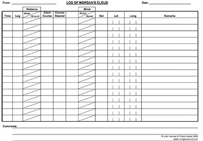
Would you mind elaborating on how you use the various columns in your log? Some of them are not clear to me, for example:
– What do you put in the “Log” column?
– What do you put in the “Distance” column? Is it distance covered since last log entry? Is “Water” value obtained by time elapsed * estimated average speed (via knotmeter)? Is “Ground” distance over ground? Are you using GPS for this, or computing via the delta latitude & longitude since last log entry, even in the case of an estimated fix (dead reckoning)?
– What is the “Bar” column, atmospheric pressure?
Thank you, I love to learn how other folks do things and get ideas.
Chuck
Hi Chuck,
Sure:
Log: Distance measured by the log rotor (through water).
Distance: Difference between two log readings (water). Distance on chart between two plots measured with dividers (ground). This is left over from when we plotted on paper. Difference tells us what current affect is.
Bar: Barometric pressure.