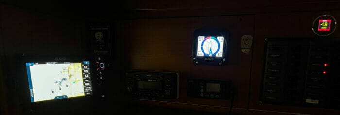
Seems like a lot of cruisers are leaving their instrumentation on, even when at anchor, these days.
Do what you want, but this practice could push you into a major electrical system makeover that might not be necessary if we just turned that stuff off.
The above photo shows the load (battery monitor to the right) from the instrument package and NMEA 2000 network on our J/109, added to a 9″ plotter.
Nearly two amps at 12 volts. Leave that on for 24 hours and that’s nearly 50 amp hours out of the battery!
And our system is comparatively small and miserly. Add in a big plotter, AIS, and worst off all, a laptop computer running navigation software, and we can easily burn through 100 amp hours or more.
To put that in perspective that’s over a third of the power Phyllis and I used in the run of a day for everything on our 56 foot live-aboard boat!
When left on all the time, small loads add up to big usage.
Here’s how to estimate usage and choose the right battery bank size, the easy way—no long boring spreadsheet to fill out…we provide a short, and not boring, spreadsheet.

Hi John and all,
We extend this “instruments on when needed” to our time offshore: once in open water and clear of obstructions, and with days of open water in front of us, instruments are turned off except AIS and wind instruments and, of course, the VHF radio which gives us a constant lat/lon read-out for transmitting with a distress signal. We turn on the chartplotter every day or so to keep up with itself.
Where instruments-left-on is a bit crazy-making are those who leave their AIS on 24-7-365, even often when tied up in the marina. Transmitting un-necessary data, I suspect, can be confusing and certainly clutters the airwaves, but may be a safety issue in some instances.
When sailing in the Solent on a beautiful clear sunny weekend, almost every recreational boat had AIS transmitting, our chart plotter was almost unreadable for the clutter: using AIS was completely un-necessary for safe piloting where careful eyeball navigation was called in these very very crowded waters. In addition, our chart plotter seized up from an over-abundance of AIS returns: not a big deal, but unsettling. I am sure the same happens in the Chesapeake and on Long Island Sound.
My best, Dick Stevenson, s/v Alchemy