
Tucked into the heart of North America, five hundred miles from the sea, lies one of the world’s great adventure cruising grounds. A quarter-million square kilometres of water, and seventeen thousand kilometres of coastline, call out to sailors seeking a season or two off the beaten path.
Superior, Huron, Michigan, Erie, and Ontario are, by salinity, freshwater lakes. By character, though, they are inland seas, stretching beyond a vanishing horizon and offering sailing challenges (and rewards) that are unique in the world.
Planning
The majority of yachts to be found on the Great Lakes have their home base somewhere on the system, and may never leave it. The lakes are, however, fully accessible to ocean-going yachts, via the locks and canals of the Saint Lawrence Seaway. Should your draught be less than five feet, and your mast foldable or easily un-steppable, the smaller historic canals of New York and Ontario become available as well.
Charted distances, on these lakes, can be deceiving when you sit down to plan your cruise. While the distance-over-the-ground from Anticosti Island at the mouth of the St. Lawrence to Duluth at the far tip of Superior is a mere 1,600 miles, few (if any) yachts make the trip up and back in a single season. This region is best explored slowly, a day at a time, leaving ample room in the schedule for weather and unexpected changes.
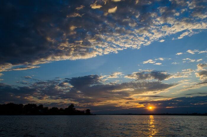
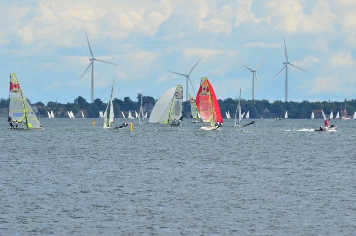
The sailing season starts in early April for hardy folks, or in late May for those without AAC-quality foul weather gear. The lower lakes remain sparsely utilized until July, when an explosion of small pleasure craft swarm out from the bustling cities of the southern lakes. By August, transient slips and good anchoring spots in the bigger cities are hard to come by, and the horizon is dotted with hundreds of sails.
Farther up the system, on Huron and Superior, even the “busy” season is hardly worthy of the name. You’ll see other boats, from time to time, but under circumstances quite the opposite of Lake Ontario’s annual three-month COLREGS test.
August and September, with few insects and generally favourable weather, are the favoured season for exploring Superior and Huron. Haul-out season starts in early October, and any boats still in the water by the beginning of November are likely to spark considerable local gossip about the competence and mental integrity of the skipper.
With the boat safely on the hard somewhere on the upper Great Lakes, winter provides a welcome opportunity for sailors to take a break from the water-borne life until the spring thaw comes and it’s time to start the journey back to the sea.
Weather
The Lakes are difficult to model accurately in weather simulations. While the same raw GFS and ECMWF data that ocean skippers are used to using is just as valid on average over large areas in the Great Lakes, small-scale variations are often much larger. It is, therefore, important to review local forecasts as well.
In general, I like to check both the raw model data and at least two independently interpreted forecasts from it, both the night before and the morning of a trip out on the lakes. If both model runs and both forecasts are consistent, that’s a good sign. Frequently, the model data for the specific grid cell in question will change considerably, and different forecast sources will disagree. That’s usually a sign of a chaotic effect at a scale too small for the global models to capture, but large enough to affect the conditions we’ll experience once we get out there. In such cases, we may change our planned destination for the day, or even stay put.
With such complicated water-land-weather couplings, the conditions can change quickly, so we keep tabs on the Environment Canada marine forecast on the VHF WX bands every hour or so. On a couple of occasions, a sudden change in that forecast has alerted us to head for a harbour a few miles away while facing only 1-2 foot chop, and we’ve arrived just in time for the whitecaps to start breaking as the club racers take in their second reef.
A cruising sailor on the Great Lakes should be prepared for any temperature and any amount of precipitation. It’s quite common to have one’s morning beverage while wearing a double layer of polar fleece, then swim and sunbathe nude at lunch, before tossing on insulated foul-weather gear for an afternoon rainstorm, followed three hours later by a T-shirt and shorts for sundowners.
Water Levels
Great Lakes cruising presents a welcome break from worrying about tides and tidal currents. That worry is, instead, replaced by worrying about water levels. The offset between chart datum and true water level varies dramatically from year to year; while all the lakes are affected, Huron is particularly notorious for having bad low-water years. It’s critical to check both the current and forecasted water levels, and to be sure that you know the correct offset relative to the datum of the charts you’re using.
Tactics
As expansive as the Great Lakes are, they’re tiny in comparison to the ocean. Open-water tactics are, therefore, often ineffective or dangerous. Large enough to breed serious storms, and small enough to ensure a rocky lee shore is always at hand, the lakes have claimed at least six thousand shipwrecks since written record-keeping began in earnest in the 17th century. Superior, in particular, is fond of snapping 700-foot freighters in half; the infamous Edmund Fitzgerald was just one of 240 ships lost within a day’s sail of Whitefish Bay.
A yacht on the open ocean might go five hundred miles out of its way to avoid a storm system that was clearly identified five days in advance. The same yacht on Superior might have only a day’s notice of an impending gale, and changing course by five miles would put it high and dry in a bear-infested forest.
Similarly, the series drogue—every AAC skipper’s favourite way of riding out a blow in blue water—might suddenly become firmly snagged to the bottom, with catastrophic consequences, if deployed in a Lake Erie gale. Should the drogue remain free, a shift of just a few degrees in the wind angle could drive the mostly-unsteerable boat ashore.
Only one Great Lakes storm tactic has survived the test of time: Always have a massive top-quality anchor ready on the bow, and a safe course to a sheltered anchorage plotted and ready to lay in. The moment the weather forecast turns unfavourable, make a beeline for that anchorage and drop the hook. Most yachts on the Lakes spend most of their time within sight of shore; passages out in the open are reserved only for the very best weather windows.
Before & After
A season on the Great Lakes segues nicely with several other popular cruising plans. The Great Loop route, popular with American and Canadian motor yachts, combines a Great Lakes cruise with the Mississippi, Tenn-Tom, Intracoastal, Erie, Rideau, and Trent-Severn waterways and canals. While fascinating for some, this route is rather busy and developed; in addition, while most cruising sailboats will find sufficient water below the keel, air draught limits on some of the canals will usually call for unstepping the mast.
High-latitude sailors may bookend a Great Lakes season via the St. Lawrence with a period on the Newfoundland & Labrador coast and another one in Nova Scotia & New England; in this case, the boat can generally be kept in full sailing trim the entire time.
Bottom line, don’t sell the Great Lakes short as a cruising destination just because the water is fresh.
Comments
Have you cruised the Great Lakes? Please share your experiences in a comment.
Hi Matt,
Interesting new knowledge for me. Your article made me explore the lakes via Google earth. The lakes do indeed look like they need a lot of time for proper exploration. I’ve never sailed them, and Amsterdam isn’t next door, but I will consider one of the rounds you mentioned. I’m always intrigued by what is new to me. I assume that is true for most here, but that you will still not get too many comments. Maybe partly due to easter, but also because there are no tech to nerd out over. I’m certainly guilty. 🙂
Matt, thanks for a nice “familiarization” piece for our “low seas”. Stein, the Great Lakes are a treasure and yet offer their own complexities in their own way. Lee shores and (in Lake Erie) comparatively shallow depths present considerations that would be familiar to Baltic sailors, I suppose, but Lake Superior is vast, deep and cold, with few harbours of refuge.
One thing sailors on Lake Ontario learn to do is to look southwestward to westward (the prevailing wind directions) on hot summer days. Squalls here (and on all the Great Lakes) can form with exceptional rapidity and can be very intense if the land to windward is hot enough. In fact, the strongest winds in which I have actively sailed have been within 10 NM of my home port (68 knots sustained). Fortunately, this sort of weather does not last long, but it underlines the need for bulletproof ground tackle.
I’ll second Marc’s comments on thunder squalls: at the first sign of a thunderstorm my first reaction after years on the Lakes in small cruising boats is still to want to drop all sail immediately. It’s taken fifteen years on the East Coast to get less cautious! It’s not only good ground tackle that’s needed, but a watchful weather eye. The squalls are usually soon over, though. Interestingly, the only place I’ve encountered thunder squalls forming with the same speed and intensity is in the Baltic.
The squalls are certainly an extra bit of fun. There have been a couple of times when we’ve been anchored at the head of Wolfe Island, where there’s a beautiful sandy beach but a lot of lee-shore exposure to the prevailing wind. Some grey turbulence appears on the horizon, and suddenly all activity on the beach stops, then twenty boats fire up their engines all at once and the Race To An East-Facing Harbour begins.
I feel like one of these could actually be a bit of fun in a well-found sea boat that can make use of the wind strength, but when you’re in something small and relatively open, it’s better to just avoid the squalls entirely.
I raced in the squall-plagued Lake Ontario 300 in 2010 and I would say that both making use of the wind and avoiding it entirely are valid options, depending on the boat. But your comments hold for either end of Lake Ontario, save we tend to get a little less warning when the squalls “fall off” the Niagara Escarpment and thump us with five to 10 minutes’ warning on a hot day.
I have sailed part of the Great lakes one september some 35 years ago on a totally unprepared trip from the Georgian Bay to Toronto and I have to agree wholeheartedly with the unpredictability of the weather. Also on the fact that my Atlantic ocean-honed instincts where of little use when the sh*t hit the fan (because of course it did !) in the confined space that is lake Erie.
Pro-tip to add to the list : make sure you are cleared visa-wise (as a person and if your country of origin demands it) for BOTH Canada and the US so as to be able to seek shelter in any port and not just on one side of the waterways. Believe me, it’s well worth the hassle.
For sure, getting fully cleared through the bureaucracy of both Canada and the USA is well advised. If you’re coming in via the St. Lawrence, you’ve probably already processed your Canadian clearance in Quebec or the Maritimes. It’s best to get your US paperwork sorted at Rooseveltown, and then you’re pretty much free to explore everywhere on both sides.
Canadian Customs can be pretty easy-going for boats, once you’ve cleared in initially. It’s often just “give us a call when you come back to our side, did you bring any guns or booze, OK good.”
The US side seems to be rather more fond of bureaucracy, and in addition to calling in at every crossing and submitting to occasional inspections, they often ask for periodic check-in calls to Homeland Security, which you’d be well advised not to neglect.
Clearing customs from the US to Canada has always been fairly easy. Go to a Port of entry, call in and answer a few questions.
In the US, believe it or not, CBP has been making progress. In many customs districts you can use the ROAM app to clear in. The Buffalo District (Erie, Ontario, and St. Lawrence River) allows use of the ROAM app. Last summer I cleared into the US as soon as I got reliable cell coverage. No muss, no fuss.
https://www.cbp.gov/travel/pleasure-boats-private-flyers/pleasure-boat-overview/roam
My problem was that, as a frenchman without a visa for entering the US (I never intended to set foot on american soil in the first place and didn’t have the time to apply for one anyway before boarding my flight to Canada), I was denied stay when we took refuge in Ashtabula (Ohio) after being dismasted in a severe thunderstorm. Everything went smoothly for my Canadian crew but because of me, the custom officer wanted to send us back out into the storm right away and I had a hell of a time negotiating a 24 hours respite.
Thankfully for me, that was in the mid-80’s and not post 9-11 or I don’t know how the situation would have ended.
Hello Jean-Philippe,
I am sorry for what happened to you in the US with our border control officialdom. I think I have visited by boat around 40 countries now and I have had some, few actually, challenging interactions. But I am clear, as much as I think some country’s have difficult rules, no other country comes close to being as difficult as the US, if reports from friends and acquaintances are any indication. And these extremely challenging, sometimes arbitrary and impossible to execute, rules etc. came way before 9-11.
My best, Dick Stevenson, s/v Alchemy
Hi Matt,
Heading your way in the next season or so and find your article a wonderful teaser. In my youth I spent part of every summer on the S shore of Lake Superior and I can attest that it is, indeed, a superior body of water.
And, also, an anecdote to support your weather observations. We did canoe trips along the Lake Superior shore upon occasion. This area was “scalloped”: rocky points with the deep bights sporting lovely sand beaches.
After following the shoreline for a couple of these scallops, I proposed, as a sassy know-it-all ~~12 year old (or so) that it would be much quicker (read easier for me) to paddle point to point rather than following the shore line. Our guide said “no” and went on the explain that midway we would be a mile or two offshore and that would not be enough time to get to shore if a Lake Superior storm came up. I thought he was way over-cautious and we could surely get to shore in a canoe safely if the weather turned.
On another lovely calm day, a year or so later, I was paddling at a rocky point when I noticed the weather deteriorating. We had about ½ mile of rocky shore that would not be fun to see close hand before we got to the beach. Within minutes of seeing clouds develop, the wind came and minutes later the waves kicked up to a point hard to not get thrown around in our canoe. We made it to the beach past the rocks, got sopping wet in a cold rain and wind (no thunder and lightning) , and 20-30 minutes later we were on our way again, our clothes drying under a warm sun.
BTW, my (limited) take on the S shore of Lake Superior is that there are few bolt holes, at least west of Marquette where I am most familiar.
My best, Dick Stevenson, s/v Alchemy
I don’t think I’d tackle Superior in a canoe. That seems just a little bit too far to the crazy side! A good sea kayak with a skirt, perhaps. Even so, I don’t think I’d want to be more than ten minutes from shore in such a small boat on a body of water that shows so much attitude.
As a Lake Erie sailor, I have longed to get my Keel salty. When it happens, maybe I’ll be more prepared than I realized. Thanks for the feature of our freshwater seas!
You likely will indeed. I was surprised to discover, when sailing on it last month, that Lake Erie is in fact tidal (after a fashion) – although not due to the moon’s gravity. Like the other Great Lakes, it is subject to wind-driven seiches, but for some reason, Erie’s are ridiculously strong – its record is something like 7 metres, although it’s normally closer to 1 or 2.
At times, the seiches create a sort of tidal current that can catch you by surprise. You’ll be alongside the pier in what appears to be a sheltered, wind-free inlet, and in the course of an hour, the water’s gone up 30 cm and there’s a 1.5 knot current trying to carry you upriver.
Hi Matt,
When I bought Alchemy, it was in Sandusky, Ohio (on Lake Erie for those not familiar with the area). I was due to pick her up a week or so before the Erie Canal opened to bring her to NY. A month or so before that, the previous owner called saying that there was no way to get it out of the marina where it was winter stored: the water was too low by about 24 inches or more along a long channel. All was looking pretty bleak when another GL sailor and friend said to watch the weather for a good storm from the NE(?) and arrange for someone to move fast. A few weeks later, this happened and, without any problem, Alchemy (with a parade of other boats I am told), was launched and moved out of the marina and taken to Vermillion where I picked her up.
Being a mid-westerner, I can attest that the Great Lakes have some unusual and surprising challenges at times.
My best, Dick Stevenson, s/v Alchemy
They do, indeed. Until I was actually in a hurricane (in Antigua on the first day of my RYA course, which was, needless to say, postponed until the next day), the strongest winds I had ever seen whilst sailing were on Lake Ontario: three brutal squalls of 45, 55 and 68 knots. They didn’t last long, true, but they played with the 47 footer on which I was crewing during a race like it was a dog’s chew toy. Atlantic squalls I’ve sailing in have had much longer wave periods by contrast.
That is a good overview of the Great Lakes and a subject I might add some personal experience and a few highlights. In general, the Great Lake offer great boating opportunities, no salt, no sharks, with the occasional exciting weather event. We have been sailing the Great Lakes for about 10 years, primarily Lake Erie but have extended that throughout the Great Lakes since we retired two years ago.
We sailed all the way around Lake Superior last summer, bypassing Duluth. Gitche Gumee is much different than the rest of the Lakes. It is vast, cold and generally remote. While the surface may warm during late summer, a strong wind will easily bring up the cold water below the surface. While waiting out a couple day storm on anchor last summer my wife and I had to dig out all the warm clothing we could find. The Canadian side of the lake is beautiful and remote with very few marinas. We noticed a couple of times while offshore after dark there were no lights visible on the shore as far as can be seen or on the water, for that matter. Anchoring is difficult at times since the water is deep right to the waters edge with a rocky bottom. Isle Royale is a jewel of the lake with wolves and moose, a US National Park, no pets allowed, even on your boat. On the southern shore several US cities should be visited such as Bayfield, WI, Marquette, MI and the lighthouse museum at Whitefish point is very good. Red agates are unique to the shores of Lake Superior and I would recommend learning how to identify them before you go.
One of the best regions of the Lakes is what is called the North Channel. This is the region of Lake Huron north of Manitoulin Island. This area should not be missed. The North Channel is very popular during the summer and people from all over the lakes visit during the summer. Anchoring is excellent. There are several Ontario towns that can provide provisions, fuel, and pump outs. There is a VHF net based out of Little Current that operates every morning. The most popular areas may be quite crowded in mid summer. The North Channel boating could be extended south along the shores of Georgian Bay; however, Georgian Bay is well known for being quite rough when the winds pick up. In northern Lake Huron, Mackinac Island has the famous Grand Hotel which was featured in my wife’s favorite movie, “Somewhere in Time”.
There are several small cities in northern Lake Michigan that should be visited. We particularly enjoyed Traverse City, last year. The city is known for cherry growing so be ready for cherry everything. They had a great farmers market, twice a week. We ran out of time last year but Green Bay is supposed to be great sailing and visiting.
Lake Erie is the shallowest lake generally about 35 ft in the western basin around the islands decreasing to 10 ft as you get close to Toledo. This makes the water warmer and rougher during a summer thunderstorm. Boating is extremely active in Lake Erie due to the concentration of large cities around the lake, the warm waters, islands and excellent fishing in the western basin. The local US Coast Guard Commander spoke at our Power Squadron club meeting last year and noted that the station at Marblehead on Catawba Island, western Lake Erie was the busiest station in the US. The islands in western Lake Erie should be visited with Put-In-Bay and Pelee island a must. The waters around the islands are crowded during the summer with fishing boats fishing for abundant walleye and perch.
A few points of business. Holding tanks must be used and overboard pumping of black water is strictly forbidden throughout the Lakes. Pump out facilities are available at most marinas at nominal cost; however we couldn’t find an operating one on the northern side of Lake Superior until we got to Minnesota. Also, Navionics electronic charts were very accurate throughout the lower lakes; however, Navionics depths were not so accurate in Lake Superior. Fishing is generally good in all the Lakes with walleye and perch abundant in Lake Erie and lake trout and various types of salmon in the upper lakes. Freighter traffic is busy during the summer and you must keep an eye out for them. You will get up close and personal with them on the river transits where they still travel at 15 -18 kn. AIS is very useful to see what’s around the bend. One final note is that the water color in the upper lakes is a beautiful clear dark blue while western Lake Erie is still troubled by agricultural runoff producing algae blooms in the warm late summer water.
There are many guides and some specialized to particular areas of the Lakes and also the Great Lakes Cruising Club is a good source of information.
While we have loved boating on the Great Lakes, we’re planning to leave this summer via the St. Lawrence, heading for warmer climes and new adventures.
Regards, Jack Price, s/v Moonlight
Heading north to the ‘North Channel’ at the top end of Georgian Bay (east side of Lake Huron), don’t forget to first visit the 30,000 Islands region of Parry Sound, the world’s largest freshwater archipelago. Navigation is tricky, but, rewarding, with access to an incredible, iconic Canadian landscape of smoothly-sculpted pink granite islands adorned with twisted windswept pines, absolutely beautiful. A little further north stop off at the Bustard Islands and then continue on to the Killarney area. The landscape there is a unique little pocket of Ontario, all-white quartzite hills and clear, turquoise water. If you have a shallow draught, the ten-mile shortcut through Collins Inlet is spectacular, followed by a trip into Killarney Provincial Park, or, if you dare, into uncharted McGregor Bay. We spent a warm, late summer morning anchored in Killarney Park’s Baie Fine, the only boat in a usually crowded anchorage, enjoying watching three river otters cavorting on the shore, it doesn’t get much better. Bears and moose are also often seen here. I’ve only touched on a few highlights of this remarkable area.
If you like more man-made spectacles, the Welland Canal between Lakes Ontario and Erie is an incredible engineering feat that takes you through a series of locks that raise you up almost 100 metres to avoid Niagara Falls. Between Lakes Erie and Huron, a night passage via the Detroit River into Lake St. Clair squeezes you through a narrow passage with Detroit’s tall skyline very close-by and blazing with lights, a mesmerizing sight.
Greetings Matt and other AAC members.
Can anyone recommend a guide or website that would explain in detail navigating the St Lawrence? Costs, locks, estimated time, customs etc etc? I am considering an eastbound from the lakes to Canadian maritimes in a 34′ Tartan (as mentioned in the article). What am I getting into? Also, any comments on the Erie canal alternative? Is it feasable to lash the unstepped mast on deck or would it be better to have it trucked to the destination? Thanks.
St. Lawrence Seaway fees, for most private vessels under 300 tons, are currently $30 per lock (i.e. $210 for Atlantic to Lake Ontario or vice versa; $240 for Lake Ontario to Lake Erie). It’s best to buy your lock pass online in advance, as paying at the lock can be a hassle.
For the eastbound transit, you’ll want to have your paperwork in order for both US and Canadian customs while still on Lake Ontario, so that you’re free to explore the Thousand Islands. It’s theoretically possible to do Lake Ontario to Quebec City in two or three days, but that would not be fun; I’d budget 5 to 10 days with plenty of time to stop and explore.
The Erie Canal is not nearly as busy as the St. Lawrence, and probably a fair bit slower. I’ve seen a number of boats traverse it with their masts lashed to temporary wooden frames on deck, which seems cheaper and more convenient than sending the mast separately by truck.
If you pay in advance make sure you purchase your pass in CAD because they have the obligation to accept transit fee on par. With the current exchange rate overing at 1.4 it is better to pay in CAD than in US. Its best to carry the amount as cash on the boat.
The time spent in the lock is impossible to predict but usually they can be made in 3 days between Montreal and Iroquois. 2 days is for a lucky boat because the speed is limited in the locks and the number of boats increase exponentially every day with the start of Construction Vacation in July. More boats means that the docks prior to a lock are occupied and you need to wait longer and locks operation are longer …but funny because most of these happy boaters have not so much experience from being thrown a rope from 50 feet up and keep the boat near the wall.
Happy sailing to all for this season !
Hi Jeffrey,
I have herd good things about The Down East Circle Route: http://www.cruisingincuba.com/down-east-circle-route/
Hi Jeffrey,
The below is almost 20 yo info.
We bought Alchemy, 40 foot hull, 16 ton, 2m draft with a big heavy stick in Lake Erie and brought it down the Erie Canal to the Hudson River. We were the first boat through in the season and worried that it may not have filled sufficiently but never touched.
On the west end there were 2 choices for stepping the mast, DIY at a small yard and a big yard who did it all. I made cross-bar cradles for our mast to carry on deck which worked fine. There are multiple choices on the Hudson, but this is much less protected water and a mast on deck is a little scary even if well secured so we went to another largely DIY yard close to the exit into the river.
The canal was a joy, but unfortunately, we were in delivery mode. If you choose this route and it is possible, enjoy the trip by going slower.
My best, Dick Stevenson, s/v Alchemy
Thank you Matt for bringing focus to the Great Lakes as an adventurer’s playground. Despite the limited length of season, and the occasional challenge of summer thermal activity, there is something simplistically special about the morning mist, fresh caught fish, and the call of a loon. Both sides of The Great Lakes are special, and advice to have passport and boat permits for both coasts is well taken. The north end of Georgian Bay and the North Channel is truly a gunkholer’s paradise and listening to the sailors’ net each morning quickly makes it apparent that this is also a place where liveaboards spend the entire boating season. Lake Superior is still on my to-do list, but lest anyone be left with the opinion that all is remote, I would also advocate for the special place that is Toronto Island. The Island is effectively a public park and being docked a 5 minute ferry ride from the lights, sights, sounds, sports, dining, and entertainment of Toronto is a vacation in itself!
Toronto Island is definitely worth a few days or weeks. Its docks are well sheltered from the wind and waves, everything from an amusement park to a major league baseball game is either walkable or a short ferry ride away, the beaches are large and clean, there’s no car traffic….. If you have any interest at all in music & culture, try to arrange your schedule to coincide with one of the many open-air concert festivals that occur along the Toronto waterfront from May to September. They’re much cheaper than you might expect, and tend to be packed with great talent.
I highly recommand Toronto Island Marina as the whole island is an amusement park and also there is a boat-taxi every 30 minutes that will carry you from your boat to downtown Toronto with the complete view of the city while crossing. And if you’re lucky, you’ll be docked to have the view on the city at night !
There is a tiny YC at the south end of the Island Marina basin called Harbour City Yacht Club that offers reciprocal visits or simply a quiet berth on, say, a weekday. See https://hcyc.ca/. Many locals buy their diesel or gasoline at the Marina and stay elsewhere.
My own club, National Yacht Club, has quite a few moorings for transient visitors and a few good docks for visiting boats (again, a weekday is easier to negotiate than a weekend) and is close to all sorts of transit options, or you can just visit our capable restaurant. The nearby Ontario Place fuel dock is convenient.
Sailors of the sweetwater seas might find useful information at https://www.great-lakes-sailing.com. A few areas on Lake Superior that are favorites are the Apostle Islands (a popular cruising ground), Isle Royale with its numerous nooks to explore, and the Slate Islands (northern and remote, being over a day’s sail from Thunder Bay).
My first experience on Lake Superior was also my first time on a larger keel sailboat in a charter course out of the Apostle Islands over 30 years ago. The afternoon winds died; no need for sails. We motored into a small protected breakwater on Stockton Island. As we sat down to dinner, the winds suddenly picked up and quickly kept building. Just 70 miles to the W an ore carrier snapped its 2″ cables setting it adrift in the Duluth harbor. Near us a few boats ended up on sand beaches. The next day left over wind and wave provided great experience for novice sailors on the big lake. Respect for the many moods of these waters comes quickly on Lake Superior.
As a long time sailor on Huron and Georgian Bay I note Matt’s comment about the size of the lakes and implications for sailing. They are too big to cross in a few hours and too small to ride out heavy weather by heaving to or using a drogue. Typically, weather events in the summer last only a few hours but that changes in October. If you are foolish enough to sail in late October while adhering to deadlines (guilty) then an ability to go to windward is important. Especially with those nasty square waves we get.
As a resource check out the Great Lakes Cruising Club at http://www.glcclub.com/. Well worth the price of admission if you are thinking of cruising the lakes. Full disclosure, I am a paying member.
Yes Ive sailed both Lake Ontario and Erie which is far dangerous due to being so shallow. Last time I was on it we went from dead calm to 10 foot hay stacks in under an hour and had to do everything we could to reach our safety harbour. Not fun. 3 people drowned that day. Absolutely crazy.
Closest reference I could find to making a passage from Kingston to Lunnenburg. Planning a delivery of a boat I want to purchase, 36 Bruce Roberts 18000 kg of steel. So the bext reference quide I coukd find is The Circke route by a local Skipper. Excellent read.
Looking fir all and any info fir this route. Is a well known passage dine frequently si kinda suro6rused that documentation is so poor. Would love to hear from anyone who has done this route. Planning for May June time frame. 6 weeks is the current fair weather max time frame.
Wooopa….. sorry for the typos. Reading glasses now on. Appologies
The Kingston to Quebec route is straightforward in the commercial channels via the 6 locks. Expect 6 days. The Quebec to Cape Gaspé is more tricky and weather dependant but you have plenty of stops every 40 miles, the current to help and you go out only with a northwester or southwester. Never on a Northeaster. Then another weather window to wait to cross to Magdalen Island (100 miles under a shallow bottom – you need fair weather). Another 2 days. Then from there to the Canso Straight another day. After that you’re on the Atlantic so ask Neptune before going out but May is a good time.
It can be done in 3 weeks no hurry, but with a weather buffer i would say 5 weeks.
Stop by Quebec to say hi ! You don’t have choice, the leg from Quebec to Cap a L’aigle is so be done by riding the tide wave – no stop permitted unless you want to anchor is 5 knots of current reverting every 6 hours. The sailing directions in Canada are now free on the internet : https://www.charts.gc.ca/index-eng.html
take plenty of time to familiarize with them… and if you need help planning your route from Quebec down let me know. I’ve done it plenty of time.
Man that is a great reference, info and insights. Gonna digest this stuff and get back to you. Thanks again. Just what I needed.