I have to confess that, now we are no longer cruising offshore, I have tended to get my weather information from Windy and call it good.
But I just realized that that lazy approach was resulting in me losing the strategic and tactical feel for the weather I developed over some five decades of observing it closely.
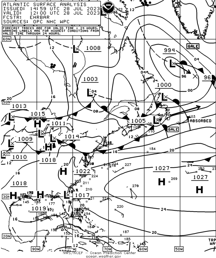
So this morning, for the first time in months, I took a look at the excellent weather maps produced by our friends to the south—thanks to all you US tax payers—and was immediately reminded why doing that pretty much every day before looking at raw-model output—that’s what Windy is, just prettied up—is way better.
All the reasons for looking at forecaster-drawn maps are beyond the scope of a tip, but the most important one is that applications like Windy do not show fronts, and if we don’t know where the fronts are, and how they work, we are just plain weather-ignorant—fronts are where most of the weather that can hurt you lurks.

To learn more, we have an Online Book. The parts about how to download the weather are out of date, but the strategic and tactical method that kept Phyllis and me safe for so many years is timeless.

Hi James,
Wow, that’s a lot of resources, and I’m sure very good. That said, I prefer to focus on a few resources that integrate into a standard method (see online book) to avoid analysis paralysis, rather than come at it from the “the more information the better” point of view, which I find overwhelming.
The list tends to be over the top for your average passage/weather planner. There are of course the main charts. The most weight given to the 500mb current/ analysis and NOAA surface ocean weather charts.
Thanks, John. I start with the UK Met Office surface pressure charts every day, then go to a more local forecaster like the Swedish, Danish, or Norwegian services, and then I go to Meteo Blue which is a spin off from the University of Basel and has just about every piece of weather information imaginable (well the paid version does for 50 Euro/year) and so many models (if you think that is useful) including their own. That is onshore. Offshore, I haven’t decided yet, but one of your members (via an article by you) suggested Weather Routing Inc. which I have tested and I believe out of all the services has both the best service (run by meteorologists) and the best software (which I think conforms to your main requirements for offshore software). I find it still a bit buggy but what isn’t? It is also the most expensive of all.
Hi Michael,
Good to gear that you go to the charts first. I was getting lazy about that, but have got right since writing the above. As to routing services, thanks for the endorsement of Weather Routing. Although I generally did my own weather over the years, for challenging passages I found Commander’s Weather very good and liked that they are totally focused on yachts and particularly sailing yachts.
Thanks, John. Being the relative novice here, I probably over-engineer everything (like I did when I built a shed in my back yard in Belgium that could withstand a hurricane…we don’t get many of them in Belgium). So, when you say things like look at the surface pressure charts, I do it religiously. Btw, when I was referring to Weather Routing Inc, I was referring to their weather software like Windy rather than their weather routing service (which I haven’t used yet but might). Their offshore software (called WRI Onboard) allows you to select any three items at the same time including your requirements of “pressure, surface wind, and rain”. But you can select quite a few other items as well such as gusts, cloud cover, and snowfall. Anyway, I am still testing it and as I say, it is expensive.
Hi Michael,
Oh, I see, that makes sense. One thought for you. I don’t tend to use autorouting software. Way too much to go wrong to the point that the results can actually be dangerous, although good in the hands of an experienced ocean race navigator who has the knowledge to evaluate the output. More in the online book about how to evaluate the weather so that you can be sure the automated software won’t lead you into a bad situation.
Understood, John and when I read your weather book previously I saw your comment and although I have not an ounce off the experience you have, I decided that weather routing software was just one algorithm too far (like you, I have (and still do) work in the software business so know the limitations). I did have one question for you, if you care to answer, as I sit out a storm in Tanager near Stavanger. What is the highest wind/sea combination you would intentionally go out in?
Hi Michael,
That would situation dependant and also depend on the boat and crew I was working with. For example I once left Greenland knowing I was going to get short lived strong gale force winds (from aft) so as to get a good weather window for the rest of the passage. But at that point both the boat and Phyllis and I were at the top of our game.
More:
https://www.morganscloud.com/2007/10/01/gale-force-is-a-lot-of-wind/
https://www.morganscloud.com/2005/01/01/taming-the-wimp-within/
Makes sense and probably was a silly question. I just like to get as much context as possible. Thanks for the links.