Question: We are planning a trip from eastern Canada to south west Greenland and return and have the following questions about ice [see specific questions and answers below summary answer].
Answer: Ice navigation is a big subject with a lot of ambiguity that generally defies any attempt at short answers. This is why we generally recommend that voyagers considering a trip to Greenland get some experience with high latitude and ice navigation in a more forgiving environment, like Svalbard or Labrador, first.


Having said that, I will have a go at answering your questions.
Q: Can I depend on the ice reports and can I ever assume the absence of a stray growler (the boat is fiberglass) regardless of the reports?
A: In Canadian waters, generally yes, as long as you are looking at the right report and clearly understand how to read it. The key issue being that berg and pack ice are reported separately. If you are outside the limit of all known ice on a Canadian berg report, you can be pretty sure, but not guaranteed, that the water is clear. (Canada has the most sophisticated ice surveillance satellite available, capable of resolving images down to 3 meters.)
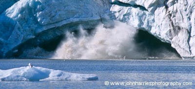
However, when you get to Greenland, you need to be aware that the excellent ice officers at Greenland Command are not really very concerned about berg ice since bergs are a fact of life in the waters they monitor nearly all of the time. Their primary job is to report on pack ice that might effect larger vessels. They also assume that larger vessels operating in the area will not be bothered by a growler and can avoid big bergs using radar. I have seen bergs and associated growlers 30 miles outside the Danish limit of all known ice.
Q: Does it make sense vis-a-vis ice to stand east before turning north?
A: Generally yes, but it depends on your departure point (a whole discussion in itself) and the year.
Q: Do we need to stop in darkness and low-visibility?
A: I can tell you that our policy on Morgan’s Cloud is to heave-to in darkness or very poor visibility—we don’t let a bit of fog stop us, since if we did we would never get anywhere—in an area with any ice reported or seen.
Having said that, have I broken the rule? Yes, plenty of times. It comes down, like so many things in the North, to assessing the particular situation and weighing competing risks. In a fiberglass boat I would be more conservative about ice risk than I am in an aluminum one.
I’m wondering about the specifics of how you access ice charts while away from internet access. I presume you are using data via satellite phone but I’m wondering if you have advice anywhere here regarding the specifics of how to do that?
Hi Gavin,
Here is a post with the answer.
You can also find specific URLs for all the ice services on the resource sheet that we emailed out after the course.